High-tech cameras made in Indiana will soon be scanning across Asia, Australia, the Americas and the Atlantic and Pacific Oceans to give weather forecasters an unrivaled minute-by-minute glimpse of the development and movement of hurricanes, typhoons and storm systems.
The result will be improved forecasts and faster updates as storms and cyclones intensify and move across land and sea.
The Advanced Baseline Imager instruments, built by Harris Corp., can see in 16 visible and infrared channels, yielding deeper insights into moisture levels and cloud types unavailable with existing weather satellite images.
“It will take the most vivid images of weather features in the Western Hemisphere, better than we’ve ever seen before,” said Greg Mandt, director of NOAA’s GOES-R program, which will debut the new class of camera over the United States. “The ABI will have 16 different spectral bands compared to just five on today’s, so that means we’ll get three times the spectral resolution to be able to see and discriminate various different features in the weather events.”
Harris, and its predecessor Exelis, also found an export market for the ABI instruments.
Two of the ABI-class cameras are already flying in space aboard Japan’s Himawari 8 and 9 weather observatories, and the advanced imager will join the U.S. weather satellite fleet with the launch of NOAA’s GOES-R spacecraft Saturday.
Harris has a contract to supply seven of the camera packages for space missions. The first two launched on Japan’s latest pair of geostationary weather satellites — Himawari 8 and 9 — in 2014 and earlier this month.
Four are assigned to NOAA’s new series of Geostationary Operational Environmental Satellites — GOES-R, S, T and U — and another Advanced Baseline Imager will launch on South Korea’s GEO-Kompsat 2A weather observatory in 2018.
Other agencies with operational geostationary weather satellites in Europe, Russia, India and China use domestically-produced cameras.
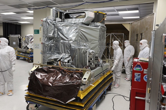
The ABIs are each about the size of a small refrigerator, and are assembled at Harris’s facility in Fort Wayne, Indiana, and tested in Rochester, New York.
All but one of the ABIs are finished and delivered to Harris’s customers. The instrument destined for the GEO-Kompsat 2A weather observatory is finishing up environmental testing before its shipment to South Korea, according to Paul Griffith, chief engineer for the ABI instruments at Harris.
The cameras aboard Japan’s weather satellites, owned and operated by the Japan Meteorological Agency, are known as Advanced Himawari Imagers, but they are nearly identical to the instruments slated to begin launching on NOAA’s GOES missions Saturday.
Two of the Harris-made cameras will have launched by the end of the month, with the successful blastoff of the Himawari 9 satellite Nov. 2 on top of an H-2A rocket and Saturday’s launch of an Atlas 5 rocket from Cape Canaveral with GOES-R.
“It’s very satisfying,” Griffith said. “It takes a lot of work and a lot of effort to build these, but we know what we’re doing is going to affect the lives of everybody in the United States, Japan, South Korea, and all around the world. We’re doing something that’s going to make a difference to everyday people, and that’s very satisfying.”
All of the ABI instruments are designed to look down on Earth from a perch in geostationary orbit nearly 22,300 miles (35,800 kilometers) above the equator, covering a fixed region that spans nearly an entire hemisphere of the planet.
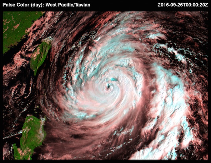
The camera on Himawari 8 has returned regular imagery since entering service in 2015 to aid Japanese weather officials and forecasters from across the Asia-Pacific, including the Australian government’s Bureau of Meteorology. Pictures from Himawari 8 have revealed typhoons churning through the Pacific Ocean, volcanic ash clouds, low-lying fog banks and other phenomena in new detail.
Each ABI works by moving two mirrors to scan in the north-south and east-west directions, allowing the camera’s sensors to build up images of the full disk of Earth, or target specific locations where severe weather merits a closer look.
“With a point and shoot camera, you use your hands to move the camera around wherever you want to go,” Griffith said. “With many space missions, they point the entire spacecraft, so the payload can observe whatever they want. With ABI, we have two can mirrors that the camera is looking out, and its line of sight reflects off one mirror that adjusts the east-west location, and the second mirror adjusts the north-south.”
With the ABI cameras, the north-south mirror’s field-of-view is 60 times bigger than possible with the imager on NOAA’s current GOES satellites, Griffith said.
“It takes about 1,370 scans to collect the full disk right now, and ABI can do it in 22 scans,” Griffith said.
“Because it takes far fewer scans, we can not only collect the image faster, but we can scan slower,” Griffith said in an interview with Spaceflight Now. “Each scan is actually much slower than with the current imager, yet we can still do more rapid collection. Scanning slower means we can collect more light, which means we can deliver the finer resolution with the same radiometric accuracy.”
The instruments can also simultaneously capture wide-angle views of the entire disk of Earth while scanning across localized regions.
In the case of NOAA’s GOES satellites, that means shots zoomed in on the continental United States, hurricanes churning in the Atlantic Ocean, and tornado outbreaks in the Great Plains. The Himawari satellites can take quick-look imagery of the Japanese islands or typhoons approaching from the Pacific.
For comparison, NOAA’s current GOES satellites can take a full disk image — covering a region from Africa to the Pacific, and from the Arctic to Antarctica — about once every half-hour. The ABI-equipped GOES-R series will take the same type of image — with higher resolution and in more wavelengths — at least once every 15 minutes, and images spanning the continental United States every five minutes.
The GOES-R series will return pictures of hotspots like hurricanes at a cadence of once every 30 seconds, an improvement from the five-minute rapid scans available today.
Griffith said Japan’s Harris-built Himawari imagers, although mechanically, optically and electrically identical to the ABIs, will be operated slightly differently at the request of the Japan Meteorological Agency.
“We have all the flexibility in how we collect images,” Griffith said. “The Japan Meteorological Agency was able to define the scan patterns that were most important to them for collecting Japanese weather, which are completely different than the scan patterns that NOAA is going to be using for U.S. weather.
“JMA is doing a 10-minute full disk, 2.5-minute updates of Japan and 2.5-minute updates of typhoons and other severe weather,” Griffith said. “So different sized images located in different places at different temporal resolutions. Each meteorological agency gets to design their own scan patterns, even though the instruments are all basically the same.”
Another small difference is Japan’s requirement to replace one of the ABI’s near-infrared channels with an additional visible channel, a green filter that allows the Himawari satellites to take better true color images of clouds over the deep blue oceans spanning the Asia-Pacific.
“In the visible and near-infrared, you’ve got six channels instead of one, which means you have the ability to distinguish smoke and haze from volcanic ash, you can do better aerosol detections for pollution and air quality, you have a better ability to distinguish snow from ice and water, and you determine the height of clouds much better,” Griffith said. “The additional infrared channels (on the ABI-class imagers) give you insight into temperature and moisture distribution through the depth of the atmosphere, and you get finer vertical resolution, so all of that combines to give the forecasters better ability to predict where storms are going to occur, and how the weather is going to evolve, as well as many other non-weather products.”
Louis Uccellini, director of NOAA’s National Weather Service, said his forecasters are eager to add the GOES-R dataset to their toolkit, and they are already testing new algorithms to process and input data into forecast models, using the similar Himawari 8 images as stand-ins.
“We’ve been practicing with the Himawari data,” Uccellini told reporters in a press briefing last month. “It was launched and placed over the West Pacific specifically to test the algorithms and get a feel for this new deluge of data that will be coming at us. We feed the real-time Himawari data to our algorithms, and we’ve gotten a look at their performance. We’re actually testing some of that data in our numerical models even as I speak.”
The Himawari 8 and 9 satellites, valued at a combined $800 million, will meet the needs of Japan’s weather forecasters through 2029, a JMA official told Spaceflight Now. Himawari 9 will enter service next year as a backup to the Himawari 8 observatory launched in 2014.
The four GOES-R series satellites will keep watch over weather in the Americas, the Atlantic Ocean and the Eastern Pacific through 2036.
Uccellini said meteorologists will better see the internal dynamics of weather systems like hurricanes, informing forecasts to predict intensification and weakening, an area where progress has lagged behind improvements in recent decades predicting hurricane tracks.
Powerful cyclones in the Pacific and the Atlantic are susceptible to changes in their eyewalls, and the sharper resolution offered by the new generation of Himawari and GOES satellites will instantly register such changes.
“When that eye collapses, that’s a sudden decrease in intensity,” Uccellini said. “Those kinds of changes we only get snapshots of today, and we clearly are looking forward to seeing those in real-time and to have that sense of development and decay.”
Email the author.
Follow Stephen Clark on Twitter: @StephenClark1.