The launch of the next Landsat land imaging mission — a joint project between NASA and the U.S. Geological Survey — has been delayed until around September 2021 after the effects of the coronavirus pandemic slowed work on the spacecraft in Arizona, NASA officials said.
The Landsat 9 satellite is the next in a series of land imaging missions launched since 1972, collecting views from space of urban sprawl, tropical deforestation, retreating glaciers, and changes in coral reefs, crops, and tectonic faults.
Previously scheduled for launch in April 2021, the Landsat 9 mission is now expected to launch in September 2021, according to Jacob Richmond, a spokesperson for NASA’s Goddard Space Flight Center in Greenbelt, Maryland.
“The Landsat 9 observatory integration is well underway, overcoming earlier spacecraft development delays that had moved the launch date into 2021,” Richmond said in response to questions from Spaceflight Now. “The pandemic has interfered with the efficiency of this work, inhibiting critical project team travel to the Northrop Grumman Space System facility in Gilbert, Arizona.”
NASA officials previously planned to launch the Landsat 9 satellite in December 2020. The mission’s $885 million budget is not expected to be affected by the delays.
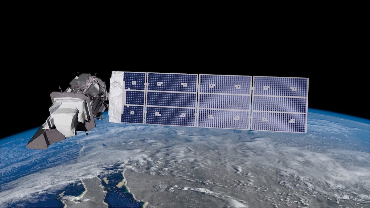
Northrop Grumman is building the Landsat 9 spacecraft for NASA and the USGS. The satellite will weigh nearly three tons when it launches, and will carry the Operational Land Imager 2 instrument supplied by Ball Aerospace and the Thermal Infrared Sensor 2 payload built at the Goddard Space Flight Center.
Dennis Andrucyk, director of the Goddard Space Flight Center, said in a virtual meeting of the Maryland Space Business Roundtable last month that “impacts” caused by the coronavirus in “processing the spacecraft” would cause a delay in Landsat 9’s launch date.
“As a result, NASA is in the process of establishing a launch date in 2021 that fits within the available windows of other prescheduled project launches and also balances the continuing risk of potential further COVID-19-related delays,” Richmond said. “NASA is now evaluating a possible launch date in September 2021, which is within NASA’s baseline commitment to Congress.”
NASA’s commitment to Congress is to launch the Landsat 9 mission by November 2021. The space agency is responsible for designing, building and launching Landsat satellites, while the USGS operates the satellites in orbit and manages the Landsat data archive, which stretches back nearly 50 years.
The OLI-2 and TIRS-2 instruments were delivered to Northrop Grumman last year and installed on the Landsat 9 spacecraft to begin electrical testing.

The Government Accountability Office, a watchdog agency, reported earlier this year that the Landsat 9 project was “experiencing ongoing delays in spacecraft electronics fabrication, flight software, and simulators that affect system integration.”
The GAO said Landsat 9 officials attributed the recent delays to issues with the performance of Northrop Grumman, the spacecraft contractor.
“The project has met with contractor management to discuss its performance, including concerns about the number and experience of staff available to complete remaining work,” the GAO said.
The GAO’s report also identified scheduling conflicts with other spacecraft under construction at Northrop Grumman’s facility in Gilbert, Arizona. Northrop Grumman allotted test equipment to another mission, which “compounded” delays with Landsat 9, officials wrote in the report.
The Landsat 9 satellite is based on the Landsat 8 mission, which launched in 2013 and continues operating. Landsat 9 will work in concert with other land imaging satellites, such as Landsat 8 and the European Sentinel 2 missions, to extend the continuous global coverage of land masses since the launch of Landsat 1 in 1972.
The data archive catalogs changes in land cover, water quality, glacier flow, and other properties of Earth’s surface, according to NASA. The thermal infrared data from Landsat satellites provide information on irrigation and water usage.
Designed for a five-year mission, Landsat 9 will blast off on top of a United Launch Alliance Atlas 5 rocket from Vandenberg Air Force Base in California. Flying in its basic configuration without any solid rocket boosters, the Atlas 5 rocket will deploy Landsat 9 into a 438-mile-high (705-kilometer) polar orbit.
Email the author.
Follow Stephen Clark on Twitter: @StephenClark1.