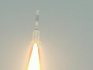
The third spacecraft to join India’s growing regional navigation system blasted off and flew into orbit Wednesday aboard a Polar Satellite Launch Vehicle.
The 146-foot-tall launcher lit its solid-fueled first stage and four strap-on rocket motors at 2002 GMT (4:02 p.m. EDT), firing away from the Satish Dhawan Space Center on India’s east coast, where it was 1:32 a.m. local time.
Lighting up the launch base as it soared skyward, the PSLV tilted east over the Bay of Bengal, igniting two additional rocket boosters to ramp up to more than 2 million pounds of thrust as it broke the sound barrier.
The rocket’s six strap-on boosters burned out and jettisoned, falling into the sea as the PSLV’s core motor continued firing toward space before consuming its propellant load and giving way to a hydrazine-fueled second stage a minute and 50 seconds into the flight.
A Vikas second stage engine fired for two-and-a-half minutes, then the PSLV’s third stage burned through its pre-packed solid fuel. A twin-engine fourth stage maneuvered the mission’s satellite passenger into geostationary transfer orbit for an on-target deployment 20 minutes after liftoff.
“India’s third navigation satellite is up in orbit,” said K. Radhakrishnan, chairman of the Indian Space Research Organization. “Our PSLV has done it again. This is the 28th flight of our PSLV, and the seventh flight of its extended version, and the injection has been really precise.”
The 3,142-pound (1,425-kilogram) spacecraft is the third launch for the Indian Regional Navigation Satellite System, a growing network of satellites to locate cars, airplanes, and shipping vessels across India and its neighbors.
P. Kunhikrishnan, mission director for Wednesday’s launch, said telemetry from the PSLV indicated it deployed the IRNSS 1C spacecraft in a nearly perfect orbit stretching from 175 miles (282 kilometers) up to 12,843 miles (20,670 kilometers) at an inclination of 17.9 degrees.
The orbit achieved by the PSLV was very close to prelaunch predictions, officials said.
The satellite extended its power-generating solar panels after separating from the PSLV, according to ISRO.
It will take between 15 and 20 days for ground controllers to guide the IRNSS 1C spacecraft into its operational geostationary orbit 22,300 miles over the equator and activate the satellite’s payload, which consists of two navigation signals in L5-band and S-band, a rubidium atomic clock to keep time, and a C-band ranging payload for engineers to measure the craft’s orbit from the ground.
Designed for a 10-year lifetime, the IRNSS 1C satellite joins two navigation satellites launched in July 2013 and in April.
A fourth Indian navigation payload is set for liftoff as soon as December, according to S.K. Shivakumar, director of ISRO’s satellite center.
In remarks after Wednesday’s launch, Shivakumar said IRNSS 1E — the fifth Indian navigation satellite, will follow with a launch in February or March.
Two more launches of IRNSS spacecraft next year will round out the navigation network.
When finished, the Indian navigation system will include three satellites in equatorial geostationary orbits and four spacecraft in inclined orbits that swing up to 29 degrees north and south of the equator.
The satellite launched Wednesday will take up the central position in the navigation fleet in geostationary orbit at 83 degrees east longitude.
India’s satellite navigation network works like the U.S. military’s Global Positioning System, using multiple spacecraft to triangulate a user’s position on Earth by measuring the time it takes to transmit and receive radio signals between space and the ground.
But the Indian satellite constellation is focused on South Asia and neighboring waters up to 900 miles from Indian borders.
Indian officials say the independent navigation service will aid marine traffic, emergency response officials, vehicle tracking applications, mobile communications, mapping, and civilian drivers.
India joins the United States, Russia, China, Europe and Japan in fielding their own space-based navigation systems for global or regional coverage.