Updated at 4:15 p.m. EST (2115 GMT) with acquisition of all eight satellites.
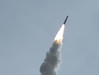
A winged Orbital ATK Pegasus XL rocket dropped from the belly of a carrier jet off the east coast of Florida and fired into orbit Thursday with eight research satellites to fly around the tropics and return measurements of winds at the cores of hurricanes.
The wind data should help scientists better understand the formation, growth and dissipation of tropical cyclones, and lessons from the $157 million Cyclone Global Navigation Satellite System may improve hurricane forecasting, particularly the strength of storms at landfall.
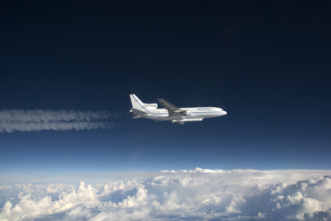
The eight CYGNSS microsatellites, each smaller than a piece of carry-on luggage, launched tucked inside the nose cone of a Pegasus XL rocket carried aloft on the belly of a modified L-1011 aircraft that took off from Cape Canaveral Air Force Station in Florida about an hour before the appointed drop time.
Following a circuitous “race track” pattern to line up with the mission drop zone, the pilots climbed to 39,000 feet (11,900 meters) and deployed the 55-foot-long (17-meter) Pegasus rocket at 1337:21 GMT (8:37:21 a.m. EST).
The stratospheric air drop occurred around 125 miles (200 kilometers) from the Florida coast at a position northwest of Cape Canaveral.
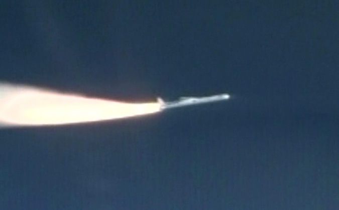
The 51,000-pound (23-metric ton) launcher armed its pyrotechnic destruct system moments after separating from the L-1011 carrier plane, the last of the 1970s-era jetliners still operational in the United States, then fired its first stage rocket motor after a five-second free fall.
The winged rocket accelerated faster than the speed of sound within 20 seconds, then pitched up to an angle of 35 degrees to climb into the rarefied upper atmosphere.
A NASA F/A-18 chase plane provided live video of the launch, which was supposed to happen Monday, but the air crew could not activate a hydraulic pump on the L-1011 carrier jet responsible for the Pegasus rocket’s release mechanism. The hydraulic issue was resolved in time for a launch attempt Wednesday, but engineers called off that try to upload new flight parameter data to the CYGNSS satellites to correct a minor software issue.
Once the winged first stage fell away, two more rocket motors ignited in succession to propel the eight CYGNSS mini-observatories into a target orbit 317 miles (510 kilometers) above Earth. Their flight path takes the satellites over parts of the planet between 35 degrees north and south latitude, the band that harbors the bulk of tropical weather development.
Telemetry from the Pegasus rocket’s third stage confirmed the eight 64-pound (29-kilogram) spacecraft, made by Southwest Research Institute in San Antonio, released from a specially-designed deployment module in pairs at 30-second intervals.
Breakwires were designed to detect each satellite’s separation from the rocket, automatically triggering the craft to switch on and kick off the first steps of the mission.

Within 10 minutes of separation, each spacecraft was programmed to unfurl its two solar array wings to a span around 5.5 feet (1.7 meters) tip-to-tip, slightly shorter than the wing span of an average adult bald eagle.
Ground controllers began hearing signals from the satellites a few hours after launch, and NASA reported that all eight spacecraft radioed engineers that they were healthy during passes over ground stations in Hawaii and Chile by around 3:30 p.m. EST (2030 GMT).
Chris Ruf, the CYGNSS mission’s principal investigator from the University of Michigan, said the first science data will come down from the satellites next week to verify the observatories are working as planned.
“It’s hard to describe how good it feels,” Ruf said after Thursday’s launch. He added that the orbit achieved by the Pegasus XL rocket was “right on the money.”
The initial data downlink is part of a two-month commissioning campaign planned by officials from NASA, SWRI and the University of Michigan before the CYGNSS satellites are available for regular science observations.
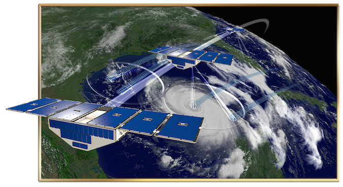
The CYGNSS spacecraft will fly around the world every hour-and-a-half, listening for navigation signals from the U.S. military’s Global Positioning System satellites bounced off ocean surfaces to derive the strength of low-level winds throughout the tropics.
The nature of the reflected GPS signal tells scientists about the roughness of the ocean, which can then be used to estimate wind speeds.
Researchers compare the way CYGNSS works to the human eye’s perception of a full moon reflected in a body of water. Calm winds will make for a perfectly resolved reflection of the moon, while windy conditions will scatter the moon’s image in a glistening effect.
“The GPS signals are there all the time, and what we’ve done with CYGNSS is we’ve taken a commercial navigation receiver and essentially hacked into it and modified its processor so that it does both navigation and it also measures the distortion in the navigation signal after it reflects off of the ocean surface,” Ruf said before the launch. “By looking carefully at the nature of the distortion, we can back out the properties of the ocean surface that are enforced by the local winds.”
Each CYGNSS observatory carries a doppler radar instrument — made by Surrey Satellite Technology, a Colorado-based subsidiary of Britain’s Surrey Satellite Technology Ltd. — consisting of two Earth-facing antennas to gather GPS radio waves scattered off the ocean, and an antenna mounted on the opposite side of the spacecraft to collect undisturbed signals directly from the GPS satellites flying more than 12,500 miles (20,000 kilometers) above Earth.
“CYGNSS is basically the receive half of a radar, and the transmit half of the radar is the GPS constellation of navigation satellites,” Ruf said.
The GPS reflections have been detected before, but have not been exploited for research.
The CYGNSS mission’s reliance on GPS signals has two key benefits.
First, the L-band frequency used by GPS satellites has a long wavelength that can pass through rain, which allows users to get their position fix in all weather conditions. Second, the CYGNSS satellites only need to carry a passive receiver to pick up the reflected radio waves, reducing the size, cost and complexity of each spacecraft.
Other satellites, even bigger observatories which use microwave radars to measure ocean winds, are not sensitive enough to see through rain and determine wind speeds at the core of hurricanes.
“Most of the missions out there are not able to look through there, so they can only see where it isn’t raining,” said Christine Bonniksen, CYGNSS program executive at NASA Headquarters. “CYGNSS will be able to see where it’s raining and what the winds are doing.”
Besides the ability to measure through rain, the CYGNSS mission will offer more rapid repeat visits over tropical cyclones than current satellites. Most Earth observation satellites are in polar orbit, which allows the spacecraft global coverage at the expense of quick data refreshes over the tropics.
“Those are the two things that we’re trying to overcome through CYGNSS,” Ruf said. “Measurement through rain and measurement more often.”
Early next year, the CYGNSS ground team will start maneuvering the satellites to their proper positions in a “string of pearls” orbit grouping.
The diminutive satellites do not have their own rocket engines, so engineers devised a way to use torque wheels to pivot the observatories up or down and use the force of aerodynamic drag to fine tune their orbits.
For example, tipping the satellite’s orientation to expose the blunt side of its solar panels to the air flow — light but still measurable at the CYGNSS fleet’s altitude — will cause the craft to slow down and change position relative to the rest of the constellation.
Once the spacing is settled, each satellite will be about 3,000 miles (5,000 kilometers) apart.
“The vast majority of hurricanes and cyclones happen in this band between plus-and-minus 35 degrees latitude,” said Aaron Ridley, CYGNSS constellation scientist at the University of Michigan. “When we decided where we wanted to launch CYGNSS, we didn’t need to go up to the poles. We needed to stay within this region. We chose the inclination of the satellites so that they will actually be in this region where all these hurricanes and tropical cyclones have happened in the past.”
CYGNSS is the first orbital mission to fly under the auspices of NASA’s “Earth Venture” program, a line of cost-capped projects aimed at answering specific questions in Earth science.
Earth Venture projects come in suborbital sounding rocket launches, instrument developments and full-up satellite missions. CYGNSS falls in the last category.
“For Earth science, this is one of our first attempts to do real operational science with a small satellite constellation,” Bonniksen said. “This is going to potentially be a game changer in how we do a lot of science.”
In the case of CYGNSS, the eight-satellite constellation will collect observations of the same point in the tropics at an average of every seven hours, a reduction from a revisit time of several days with polar-orbiting satellites.
“This is one of the our missions that has come in on cost, on schedule, on science and to me that’s an exciting thing to see,” Bonniksen said of CYGNSS.
Thomas Zurbuchen, head of NASA’s science mission directorate, said Wednesday that the space agency could do more science with flocks of small satellites, especially in fields like Earth science and heliophysics, the study of the sun and its link with Earth.
“Just because of orbital dynamics, a single spacecraft can overfly a single sopt every X days or X hours, depending on how high you fly and the inclination,” Zurbuchen said. “It may be every four days, or every two days.
“With many spacecraft, that can be done a lot more often as we’re learning from Planet Labs and (other) commercial providers, but also from spacecraft that we’re building in our own portfolio,” Zurbuchen said.
Future Earth Venture investigations include TEMPO, an air pollution monitor to fly on a geostationary telecommunications satellite, the ECOSTRESS vegetation instrument to fly on the International Space Station, the MAIA twin-camera payload to identify the sizes and compositions of the particulates in air pollution, and TROPICS, a set of 12 CubeSats designed to fly over tropical cyclones and measure their characteristics as frequently as every 21 minutes.
NASA announced last week the selection of the second mission-class Earth Venture project, GeoCARB, which will launch an instrument piggyback on a commercial SES-owned geostationary communications satellite to study the health of vegetation and greenhouse gases over the Americas.
Like all the other Earth Venture missions, GeoCARB was selected by NASA from multiple proposals through a competition. Researchers from the University of Oklahoma are leading the $166 million GeoCARB mission.
CYGNSS should be fully operational in time for the start of the 2017 hurricane season in the North Atlantic, but it could see action before then if cyclones form elsewhere in the tropics.
Forecasters at NOAA’s National Hurricane Center will not get real-time data from the CYGNSS satellites. The spacecraft will beam down their measurements to scientists via ground stations in Hawaii, Chile and Australia, so the observatories will record and store their data on-board until passing within range of one of the mission tracking facilities.
NOAA operates the government’s primary satellites to help in real-time weather forecasting, while NASA missions are geared toward research and development. CYGNSS objectives include the demonstration that reflected GPS signals are useful for tropical weather forecasting, and the collection of new insights into the inner workings of hurricanes.
Research lessons learned from CYGNSS could be applied to a future satellite mission to route data on active hurricanes to forecasters, or to improve that numerical computer models that generate tropical weather predictions.
Hurricane experts from the National Hurricane Center plan to examine the data to determine its utility in operational forecasting.
“With eight satellites, and with each satellite being able to make four measurements of the wind, it’s kind of like having 32 virtual P-3 (hurricane hunter) airplanes some place in the tropics measuring winds at all times,” Ruf said.
Ruf said scientists are specifically interested in using data from CYGNSS to better predict intensity fluctuations in tropical cyclones. Such changes in strength are notoriously difficult to predict, and they could mean the difference between life and death for residents on the coast.
“For the most part, there’s been little improvement in our ability to forecast how strong a hurricane is going to be, but a lot of improvement in forecasting where it’s going to go,” Ruf said.
The only sure way to detect winds in the heart of a hurricane now is with NOAA and U.S. Air Force hurricane hunter aircraft, which fly through a storm’s eyewall to directly sample the conditions at the most intense part of the cyclone.
“The limitation with this is you can only do this by getting an airplane out into the hurricane,” Ruf said. “We’re trying to take this type of measurement capability and extend it into space with CYGNSS.”
Email the author.
Follow Stephen Clark on Twitter: @StephenClark1.