Your daily dose of planet Earth is now just a click away, thanks to a new NASA website hosting photos looking back at the world from a small satellite stationed almost a million miles away, realizing a dream of former Vice President Al Gore nearly two decades ago.
The Earth views are not the primary purpose of the $340 million Deep Space Climate Observatory, but the imagery will be piped to the devices of anyone who wants to see what their home planet looks like every day, surely making the photos the most publicly accessible part of the mission.
The result of a space mission first proposed by Al Gore in 1998, DSCOVR blasted off in February aboard a SpaceX Falcon 9 rocket after years of starts and stops before finally winning final launch approvals under a partnership between NASA, NOAA and the U.S. Air Force. Its main objective is to track the solar wind streaming toward Earth from the sun, giving warning of incoming solar storms that could disrupt air travel, electrical grids, communications and satellite operations.
But the spacecraft also has a camera looking back at Earth, and a NASA website went live Monday showing the latest views from DSCOVR.
DSCOVR reached its operating post at the L1 Lagrange point between Earth and the sun in June. The position gives the spacecraft uninterrupted views of the sunlit side of Earth and a place embedded in the stream of particles making up the supersonic solar wind flowing from the sun.
Gore envisioned a satellite with the ability to beam back non-stop live views of Earth on the Internet. DSCOVR will not quite reach that goal, but Gore celebrated the mission’s achievement with a tweet Monday.
DSCOVR’s site displaying new daily images of Earth from L1 was launched today! Congratulations to all those who made this happen!
— Al Gore (@algore) October 19, 2015
A noted environmental activist, Gore told reporters in Cape Canaveral before DSCOVR’s launch that the near-realtime views of our home planet “can add to our way of thinking about our relationship to the Earth and, of course, the Earth’s ecosystem.”
NASA says it will post a set of images from the satellite’s Earth Polychromatic Imaging Camera — known by the acronym EPIC — every day. Each new post will include at least 12 pictures, showing Earth as it rotates through a day, according to the space agency.
The website also includes an archive of imagery searchable by date and continent.
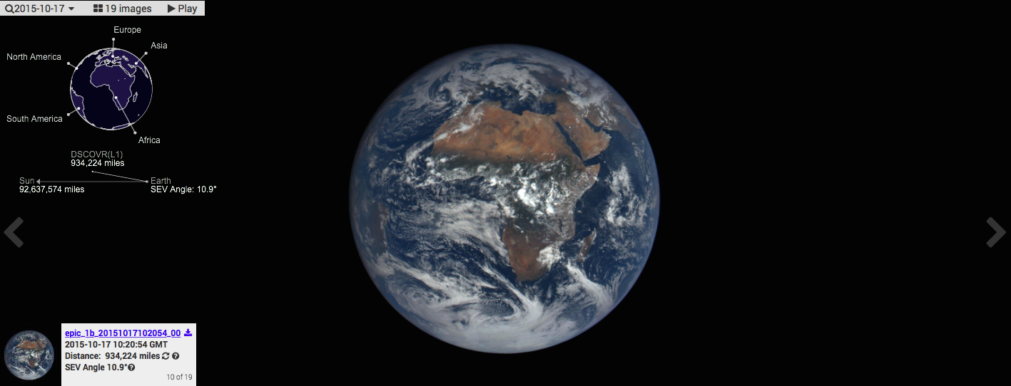
Each EPIC image is about 3 megabytes in size, according to NASA, and the full disk Earth views are composed by combining three separate images taken through different color filters inside the camera. The finished product is equivalent to a photo from a 12-megapixel camera.
The instrument is managed by NASA and includes other spectral channels scientists say can be applied to studies of the ozone layer, vegetation, aerosols and clouds.
NASA says the resolution of the EPIC pictures ranges between 6.2 and 9.4 miles (10 and 15 kilometers), and the short exposure times required to image Earth, which is much brighter than the background blackness of space, renders points of starlight invisible.
DSCOVR also hosts a NASA sensor designed to measure how much of the sun’s energy is absorbed and reflected from Earth.
NOAA is in charge of the overall mission and instrumentation focused on space weather forecasting. The spacecraft is designed to last at least two years but carries enough propellant to survive at least five years.
“DSCOVR will serve as our tsunami buoy in space, if you will, giving forecasters up to an hour’s warning of these huge magnetic eruptions from the sun that occasionally occur, called Coronal Mass Ejections, or CMEs,” said Tom Berger, director of NOAA’s Space Weather Prediction Center in Boulder, Colorado, before the mission’s Feb. 11 launch.
Email the author.
Follow Stephen Clark on Twitter: @StephenClark1.