VANDENBERG AIR FORCE BASE — From weather forecasting to agricultural benefits, a new NASA mission launching this week will provide unprecedented detail, accuracy and coverage of soil moisture from space on a world-wide basis every three days for the next three years.
“Moist soil is far more interesting than you might have ever imagined,” said Sam Thurman, SMAP deputy project manager.
“Soil moisture is the bank account of water in the land,” added Dara Entekhabi, SMAP science definition team lead.
The $916 million Soil Moisture Active Passive (SMAP) mission is one piece of a larger program of Earth science projects in space to answer questions about how our planet works.
“SMAP will be joining our 18 operational missions that study the Earth’s systems. These issues that are addressed by this are climate change, things like sea level and fresh water resources. Our on-orbit satellites, along with air and ground observations, monitor the Earth’s vital signs,” said Christine Bonniksen, SMAP program executive with the Science Mission Directorate’s Earth Science Division at NASA Headquarters.
![]() “I started out as a planetary science guy, which tended to have a spacecraft and large suite of instruments to go some place and do many different investigations in parallel, in part, because no one may go there again for 10-20-30 years.
“I started out as a planetary science guy, which tended to have a spacecraft and large suite of instruments to go some place and do many different investigations in parallel, in part, because no one may go there again for 10-20-30 years.
“As I’ve come to learn in the Earth science program is that the Earth’s climate is particularly complex…It takes a multitude of missions, each capable of dedicated set of measurements, and then scientists build a more comprehensive picture of our planet,” said Thurman.
In the case of SMAP, the observatory’s focused science goal is mapping global soil moisture content in the top two inches of the ground and determine whether that moisture is liquid or frozen.
“We have the ability to do that on a global basis and with an accuracy that is roughly 10 times greater than what’s achievable with ground-based measurements today,” Thurman said.
Liftoff is scheduled for the precise moment of 6:20:42 a.m. local time (9:20:42 a.m. EST; 1420:42 GMT) at the opening of a three-minute window on Thursday.
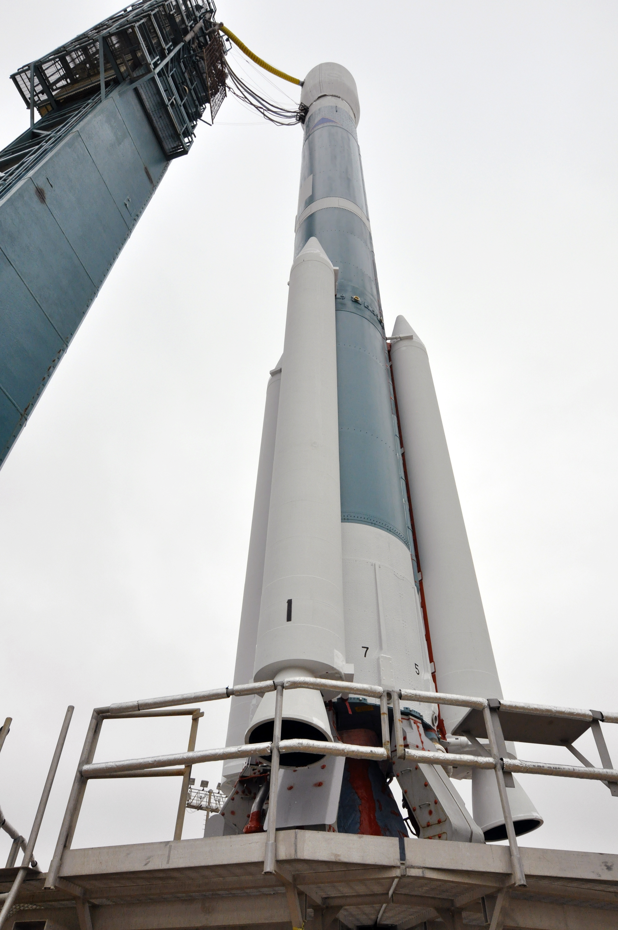
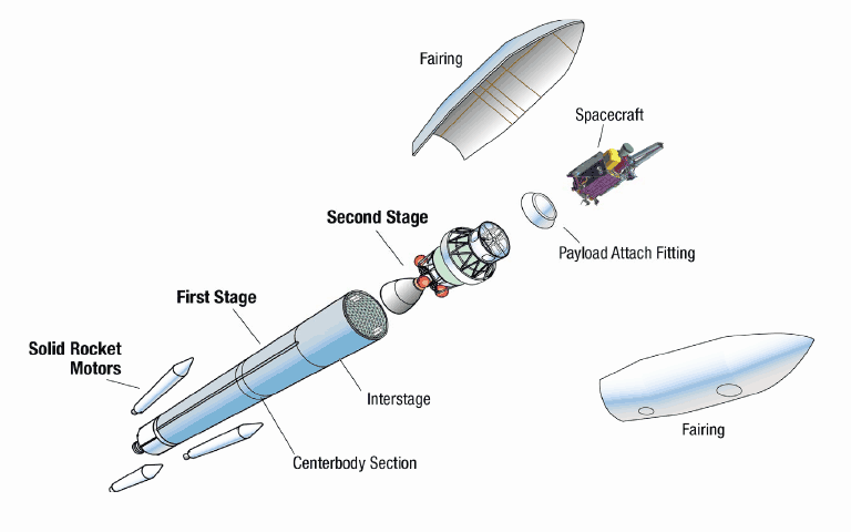
A United Launch Alliance Delta 2 rocket will serve as the launch vehicle to deliver SMAP into space. The Delta 2, making its 153rd launching, will fly in a configuration with two stages, three strap-on solid-fuel boosters and a 10-foot composite payload shroud.
 “The ULA team is proud to be the launch provider for NASA’s Soil Moisture Active Passive (SMAP) mission,” said Jim Sponnick, vice president of Atlas and Delta Programs.
“One of four first-tier missions recommended by the National Research Council’s Committee on Earth Science and Applications from Space, SMAP will provide global, high- resolution mapping of soil moisture and its freeze/thaw state to link terrestrial water, energy, and carbon-cycle processes, and to extend capabilities of weather and climate prediction models.”
It will take 57 minutes and two firings by the upper stage to place SMAP into its preliminary orbit of 411 by 425 miles tilted 98.1 degrees to the equator.
Also sharing the ride to orbit will be four cubesats as part of NASA’s Educational Launch of Nanosatellites 10 (Elana 10) mission.
* ExoCube, a space weather satellite developed by California Polytechnic State University, San Luis Obispo, and sponsored by the National Science Foundation.
* The GEO-CAPE ROIC In-Flight Performance Experiment (GRIFEX), is a technology validation mission developed by the University of Michigan’s Michigan Exploration Laboratory in partnership with NASA’s Earth Science Technology Office and NASA’s Jet Propulsion Laboratory.
* Focused Investigations of Relativistic Electron Burst Intensity, Range, and Dynamics II (FIREBIRD-II A and B), another space weather project, was developed by the University of New Hampshire, Montana State University, Los Alamos National Laboratory and the Aerospace Corporation.
The upper stage will deploy SMAP, then perform an engine burn that lowers the orbital altitude before systematically ejecting the cubesats one hour and 45-48 minutes after launch.
The upper stage then executes one further burn to deorbit the spent rocket body into the South Pacific.
The SMAP spacecraft, orbiting at a final science altitude of 426 miles (685 km), will see through moderate vegetation, like a mature Iowa corn field, operating in daylight or darkness, to provide high-resolution maps of moisture in the soil and the state of the ground — either frozen or thawed — to give weather forecasters a better base for computer forecasting models.
Government and commercial users of the data will feed the information into weather forecasting, climate modeling, drought, landslide and flood predictions, agricultural productivity, crop yields and growing season durations, and human health issues.
“We’ll return over 130 gigabytes of data every day. So if you think of a typical Netflix movie as 2-3 gigabytes, we’re doing 50 Netflix movies a day,” said Thurman.
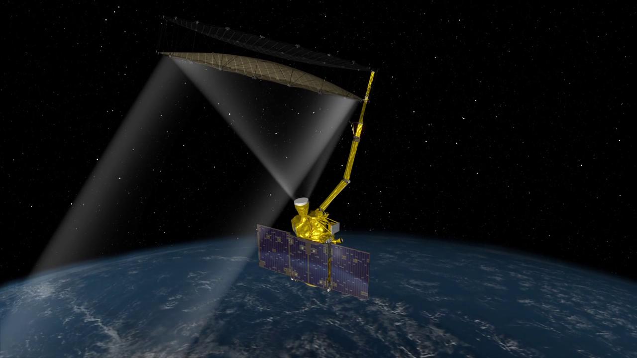
SMAP is fitted with an active synthetic aperture radar and passive radiometer. It stands 16 feet tall at launch, then blossoms to 32 feet once deployed in orbit. The weight at launch is 2,081 pounds.
“The radiometer provides more accurate soil moisture but a coarse resolution of about 40 kilometers (25 miles) across,” said JPL’s Eni Njoku, a research scientist with SMAP. “With the radar, you can create very high resolution, but it’s less accurate. To get both an accurate and a high-resolution measurement, we process the two signals together.”
 “These two science instruments and mission operations concept are optimized to provide high quality soil moisture data,” said Entekhabi.
“The radiometer instrument acts much like a camera. It sees the ambient light environment, in this case beyond the visible range in the microwave range, and the specific advantage of the microwave range is you can see in daylight and at night, you can see through clouds, you can penetrate moderate vegetation and in fact peer into the soil for a few inches to actually measure the volume of water in the soil.
“The resolution, the size of the features on the ground that you can see with the radiometer is limited by the size of the antenna, the reflector in this case, and that’s about 40 kilometers for the SMAP radiometer antenna.
“In order to augment that, SMAP carries another instrument package, which is the radar. And that one acts like a flash camera, it actually emits light, or in this case a microwave pulse, and looks at the reflection of that off the surface. And much like the flash camera, you can see a lot more detailed features on the surface. But you’re susceptible to scattering off surface vegetation and surface roughness. So it’s less sensitive than the radiometer to soil moisture, but it’s at muchy higher resolution, on the order of 3 kilometers.
“The combination of these two is what produces the SMAP high quality soil moisture retrievals.”
The radar and radiometer are like looking through both lenses of bifocals, said Bonniksen. “SMAP…will focus on the water that lives and moves through the soil. This information will improve our knowledge of weather, climate over land as well as water-related hazards,” she said.
SMAP is equipped with a 19.7-foot deployable gold, lightweight, rip-resistant mesh reflector antenna atop a boom structure that spins at 14.6 rpm (one complete rotation every four seconds) and measures the planet in swaths of 620 miles.
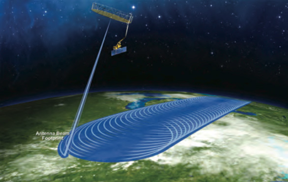
“The antenna needs to be large in order to have high-resolution, it needs to spin because the antenna is looking off at an angle, and we spin it so that it sweeps out a circle underneath the observatory, which allows us to measure 1,000 km wide swath…to measure the entire globe every 2-3 days,” said Kellogg.
On Day 16, the boom supporting the antenna will be unstowed and extended into a “tail wagging the dog” configuration. It will take 16 minutes for the 16-foot arm to unfold and lock into place.
Next, on Day 20, after a few days of monitoring the spacecraft performance in the boom deploy configuration, the antenna itself will be unfurled like a camping chair in a 33-minute procedure.
The antenna is stowed in a 12-inch-diameter, four-foot-long package for launch. Initially, it is allowed to “bloom” outward to 7-foot in diameter before being driven to the full 20-foot expanse.
About 50 days after launch the spin-up sequence begins. In between, the science instruments will be checked out and the science-gathering orbital altitude will be tweaked.
The spinning initially goes to 4.5 rpm for a few days of testing before gradually stepping up to the nominal 14.6 rpm within 60 days of launch.
The nominal science mission begins 90 days after liftoff.
The spacecraft’s goals of the 39-month mission include:
* Understand processes that link Earth’s water, energy and carbon cycles on land.
* Estimate flows of water and energy between the atmosphere and land globally.
* Quantify the net transfer of carbon between the boreal forests and atmosphere.
* Enhance weather and climat forecasting accuracy.
* Develop improved flood prediction and drought-monitoring capability.
“What’s unique about SMAP science returns is that it has returns in two very distinct areas. One of them is in fundamental understanding of how the environment works, It’s addressing some fundamental Earth science questions. The second is in the arena of applications. SMAP provides data that affect our everyday lives in terms of dealing with some really serious natural hazards,” said Entekhabi from the Massachusetts Institute of Technology in Cambridge.
“In terms of Earth science, there are three fundamental cycles that make lives possible on Earth. The water cycle, the energy cycle and the carbon cycle over land are linked through the soil moisture variable. If it wasn’t for the soil moisture variable, these three processes over land would vary independently, but they don’t. They work in concert like gears in a clock, they are linked together through the soil moisture variable.”
“With the launch of this project, decision makers will be better able to understand the water cycle and how soil moisture fits into that. The soil actually gathers the precipitation prior to it entering he rivers and then evaporating back into the atmosphere. As a result, soil moisture impacts many areas of human interest, including flood, drought, disease control and weather,” said Bonniksen.
See our earlier SMAP coverage.
And see our Delta archive for further information.