A replacement for an aging satellite in Japan’s regional navigation network successfully launched Monday from Tanegashima Space Center aboard an H-2A rocket, heading to an orbit more than 20,000 miles above Earth.
The launch keeps Japan on track to establish an independent seven-satellite navigation network to provide continuous coverage over the country’s territory.
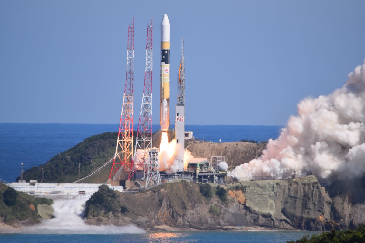
Rocketing away from Tanegashima on a 174-foot-tall (53-meter) H-2A rocket, the new navigation station streaked into space to join three other spacecraft in Japan’s Quasi-Zenith Satellite System, which augments positioning and timing signals from the U.S. military’s GPS network over the Asia-Pacific region.
The new satellite, named QZS 1R, took off at 10:19:37 p.m. EDT Monday (0219:37 GMT Tuesday) from Japan’s primary spaceport, located on Tanegashima Island in the southwestern part of the country.
The H-2A rocket carrying the QZS 1R, or Michibiki 1R, satellite into space lifted off with 1.4 million pounds of thrust from two strap-on solid rocket boosters and a hydrogen-burning core stage engine.
Heading east over the Pacific Ocean, the H-2A shed its spent booster casings nearly two minutes into the mission. The rocket’s aerodynamic payload shroud jettisoned more than four minutes into the flight, once the launcher soared above dense, lower layers of the atmosphere.
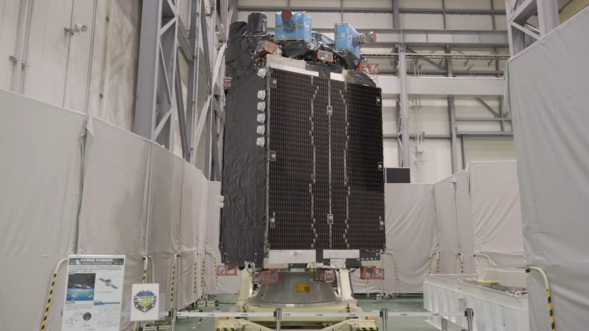
The core stage shut down and jettisoned about six-and-a-half minutes after liftoff, and the engine on the H-2A’s second stage ignited for two burns to inject the 4-metric ton (4.4-ton) QZS 1R spacecraft into an elliptical, or oval-shaped, transfer orbit.
The rocket’s guidance computer targeted an orbit with an apogee, or high point, more than 22,000 miles (about 36,000 kilometers) above Earth.
The launcher hit its marks and deployed the QZS 1R spacecraft into its intended orbit, according to Mitsubishi Heavy Industries, the H-2A rocket’s prime contractor.
The mission marked the 44th launch of an H-2A rocket, Japan’s most-used launch vehicle, since its debut in 2001. It was the 47th consecutive successful launch by the H-2 rocket family, which includes the more powerful H-2B launcher used for International Space Station resupply missions.
The flight was delayed 24 hours because of a poor weather forecast for the mission’s first launch opportunity.
Designed for a 15-year lifetime, the QZS 1R spacecraft will use its own propulsion system to reach a near-circular geosynchronous orbit with an average altitude of about 22,000 miles. The satellite will settle into an operational orbit tilted between 40 and 45 degrees to the equator, where it will circle the planet once every 24 hours.
QZS 1R will replace the QZS 1, or Michibiki 1, navigation satellite launched on a previous H-2A flight in 2010. Three other quasi-zenith navigation satellites launched in 2017.
The four-satellite QZSS fleet, entirely compatible with the GPS network, is positioned in orbits that loiter over Japan. GPS satellites, operated by the U.S. Space Force, circle Earth in lower orbits, meaning different spacecraft are visible in the sky at different times.
Projected against Earth’s surface, the QZS 1R satellite’s ground track will chart an asymmetric figure-eight pattern stretching from Japan to Australia as it alternates north and south of the equator. Three of the active quasi-zenith satellites are positioned in similar inclined geosynchronous orbits, and another one is parked in geostationary orbit over the equator, remaining in a fixed position over the planet.
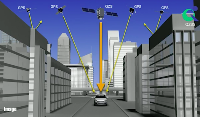
Like the satellite it’s replacing, QZS 1R will be near-zenith, or almost straight up, in the Japanese sky for about eight hours each day. With a full complement of satellites, the constellation permits continuous coverage of Japan.
Michibiki means “guiding” or “showing the way” in Japanese.
It takes four GPS satellites to calculate a precise position on Earth, but a Michibiki satellite broadcasting the same L-band signals will give a receiver an estimate if there are not enough GPS satellites visible, or it can help produce a more accurate position calculation even with full GPS service.
Japan is developing three more quasi-zenith navigation satellites for launch by the end of 2023. The expanded fleet of seven spacecraft will give Japan complete navigation coverage over Japanese territory, independent of any GPS signals.
The launch of the H-2A rocket Monday from Tanegashima cleared the way for Japan’s space agency to resume preparations to launch a smaller Epsilon rocket from Uchinoura Space Center on the nearby Japanese island of Kyushu.
The Epsilon rocket was supposed to launch earlier this month with a batch of small technology demonstration satellites, but managers scrubbed two launch attempts due to a ground radar problem and unfavorable high-altitude winds.
After the delays, Japanese officials decided to ground the Epsilon rocket at Uchinoura and press ahead with the launch of the H-2A rocket from Tanegashima. Although the rockets take off from different spaceports, they share some ground support infrastructure, requiring spacing between the missions to reconfigure for the next launch.
Officials have not set a new target launch date for the Epsilon mission.
The next H-2A rocket is scheduled to launch in December with a commercial communications satellite for Inmarsat, a London-based provider of voice, video, and data relay services for ships, airplanes, and other mobile customers.
Email the author.
Follow Stephen Clark on Twitter: @StephenClark1.