NASA’s ICESat 2 satellite has been bolted atop a United Launch Alliance Delta 2 rocket at Vandenberg Air Force Base in California as ground teams prepare for the workhorse launcher’s final liftoff Sept. 15.
Equipped with a six-beam laser altimeter, the spacecraft will monitor changes in Earth’s land and sea ice, continuing a series of measurements which have shown ice is melting around the edges of Greenland and Antarctica, and is thinning in the oceans.
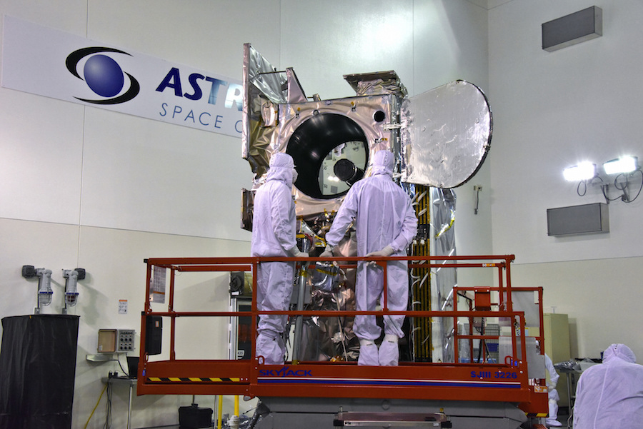
ICESat 2 — short for Ice, Cloud and land Elevation Satellite 2 — was raised atop the Delta 2 rocket early Sunday at Vandenberg after a short road trip inside a shipping container from a nearby Astrotech satellite processing facility. A crane hoisted the spacecraft — about the size of a small camper trailer — into the mobile gantry at Vandenberg’s Space Launch Complex 2-West, the Delta 2’s West Coast launch pad.
Ground crews lowered the spacecraft atop the Delta 2’s second stage, then began preparations to install the rocket’s clamshell-like payload fairing around the satellite, the final step in assembly of the 128-foot-tall (39-meter) launch vehicle.
The spacecraft’s transfer to the launch pad occurred two days later than planned to resolve an issue with a piece of ground support equipment, but the the schedule hiccup is not expected to delay the launch.
Liftoff is scheduled for Sept. 15 at 5:46 a.m. PDT (8:46 a.m. EDT; 1246 GMT) on the 155th and final flight of ULA’s venerable Delta 2 rocket.
Heading south from Vandenberg, the Delta 2 will shed its four solid rocket boosters and kerosene-fueled first stage. Two firings of the Delta 2’s second stage engine will maneuver the ICESat 2 satellite into an orbit at an altitude of around 300 miles (500 kilometers).
Separation of ICESat 2 from the Delta 2 rocket is expected nearly 53 minutes after liftoff, followed by a third burn of the Delta 2 upper stage engine to set up for deployment of four tiny CubeSats developed by students at UCLA, Cal Poly and the University of Central Florida.
A fourth burn by the Delta 2’s second stage engine will de-orbit the rocket for a fiery, destructive re-entry to avoid creating space junk.
The launch next month will mark the retirement of the Delta 2 rocket after a storied record of missions since its debut in 1989. Delta 2 rockets have launched NASA probes to the moon, Mars, Mercury, comets and asteroids, plus all of the U.S. Air Force’s Global Positioning System navigation satellites in the 1990s and 2000s.

The ICESat 2 satellite was built by Northrop Grumman Innovation Systems, and its single instrument — the Advanced Topographic Laser Altimeter System, or ATLAS — was developed at NASA’s Goddard Space Flight Center.
The ATLAS laser will split into six beams once it leaves the instrument. ICESat 2 will measure the time it takes for the laser beams to bounce off of Earth’s surface and return to the satellite, giving scientists information about the height of ice sheets and forest canopies.
“ATLAS essentially acts like a stop watch,” said Donya Douglas-Bradshaw, ATLAS instrument manager at Goddard. “The ATLAS laser fires 10,000 pulses per second with a trillion photons in each shot. Each time the laser fires, it starts the stop watch. It takes about 3.3 milliseconds for the beam to exit the instrument, reach the surface and return back to the telescope.”
The laser package “has the ability to time tag a single photon to billionth of a second accuracy,” Douglas-Bradshaw said in a briefing with reporters last week. “This precision allows the instrument to detect annual changes in ice elevation on the order of half of a centimeter (0.2 inches).”
The ICESat 2 satellite weighs around 3,340 pounds (1,515 kilograms) at launch, according to Doug McLennan, ICESat 2’s project manager at Goddard.
McLennan said the spacecraft has enough fuel to operate more than 10 years. ICESat 2’s primary mission is scheduled for three years, but could be extended.
ICESat 2 is a more advanced replacement for NASA’s ICESat satellite, which measured ice coverage and thickness from 2003 through 2009. ICESat carried a laser producing a single beam, while ICESat 2’s upgraded laser instrument will generate six beams to better see where ice is melting and flowing, helping quantify and identify the impacts of warming global temperatures.
The ICESat 2 mission is expected to cost NASA more than $1.05 billion, including expenditures during design, development, launch and operations of the satellite.
NASA mounted airborne ice research campaigns since ICESat’s laser instrument failed in 2009, continuing observations of certain ice flows to bridge the gap between ICESat and the launch of ICESat 2. But global coverage will only resume with the launch and commissioning of the new satellite.
“Since the end of the first ICESat mission, NASA has not had the ability to measure ice sheet surface elevation and sea ice thickness on a global scale,” Richard Slonaker, ICESat 2 program executive at NASA Headquarters. “That all changes with the launch of ICESat 2.”
“What we are hopeful for is that we are going to be able to tie changes in the land ice and sea ice to other specific changes in the Earth system,” said Tom Wagner, cryosphere program scientist at NASA Headquarters.
“Ultimately, what we’re trying to understand are the processes and the climate drivers that are guiding this change,” Wagner said.
Email the author.
Follow Stephen Clark on Twitter: @StephenClark1.