The first node of a space-based European laser communications network will soar into orbit Friday aboard a commercial Eutelsat broadcasting spacecraft, setting the keystone for a satellite system to relay vast volumes of imagery at lightning fast speeds.
A laser communications terminal affixed to the Eutelsat 9B telecom satellite set for launch Friday will collect data from spacecraft circling a few hundred miles above Earth such as Europe’s Sentinel environmental satellites and the International Space Station, officials said.
“It’s a kind of broadband network in space offering capabilities to transmit a large amount of data from Earth observation satellites down to Earth,” said Magali Vaissiere, director of the European Space Agency’s telecommunications and integrated applications division.
The laser link is the product of a quarter-century of development and testing across Europe, but focused in Germany, the European Data Relay System’s chief financial contributor.
Officials said the EDRS program cost about 500 million euros ($545 million), accounting for development of the laser system, two communications packages in geostationary orbit, and ground stations.
Airbus Defense and Space, the EDRS prime contractor which aims to sell the laser relay service commercially, provided about one-third of the funding, with European governments paying the rest, according to Evert Dudok, head of communication, intelligence and security at Airbus Defense and Space.
Eutelsat 9B hosts the first of at least two EDRS laser communications packages confirmed for launch. A satellite primarily dedicated to the data relay system will follow with a launch in mid-2017.
The European television broadcast satellite is buttoned up inside a Proton rocket for liftoff at 2220 GMT (5:20 p.m. EST) Friday from the Baikonur Cosmodrome in Kazakhstan.
The Proton’s Breeze M upper stage engine will propel Eutelsat 9B into an elliptical transfer orbit, then the craft’s on-board propulsion system will steer it into a circular geostationary orbit nearly about 22,300 miles (nearly 36,000 kilometers) above the equator.
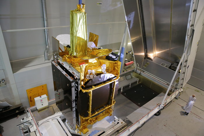
Owned by Paris-based Eutelsat, the satellite’s main mission is to beam hundreds of television channels to customers across Europe from a geostationary operating slot at 9 degrees east longitude.
A deal brokered between Eutelsat, ESA and Airbus Defense and Space — builder of Eutelsat 9B — led to the addition of the laser communications terminal on the spacecraft.
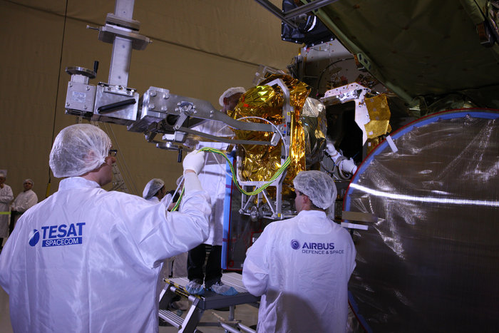
The add-on payload weighs about 116 pounds, or 53 kilograms, and measures slightly larger than a normal kitchen microwave oven. It was built by Tesat Spacecom, a German company owned by Airbus.
ESA flew a pathfinder laser communications terminal on the Alphasat communications satellite launched in 2013, which demonstrated successful optical data links with the first two Sentinel satellites — Sentinel 1A and Sentinel 2A — over the last two years.
If all goes according to plan, ground controllers will activate the laser system aboard Eutelsat 9B shortly after launch and complete the checkout of the terminal by May, said Michael Witting, EDRS program manager at ESA.
The system should be operational by mid-2016 and begin relaying images captured by the Sentinel 1 and Sentinel 2 satellites, which observe the planet with radars and optical cameras, respectively, he said.
The Sentinel satellites are part of the European Commission’s Copernicus program, a multibillion-dollar fleet of spacecraft designed to record data on Earth’s land masses, vegetation, oceans, atmosphere and ice coverage with unprecedented regularity.
Getting the environmental data into the hands of users — including security agencies, maritime operators, businesses, farmers, scientists and European citizens — is paramount to fulfilling the promise of the Copernicus program, officials said.
The data relay network developed by Europe will pass up to 50 terabytes of data between observation satellite and users every day.
“EDRS is the tool that will make Earth observation on such a scale a manageable proposition,” Vaissiere said in a Jan. 15 press conference. “The maritime sector is the one currently crying out loudest for more real-time data. For example, some important shipping routes go through the North Pole region, where thick ice flows can cause damage to cargo and vessels and even threaten human life.
“It’s also an environment which is on constant motion, so data that is two days old is not only unhelpful, it could even be unsafe,” Vaissiere said. “EDRS is supposed to make this data accessible quickly.”
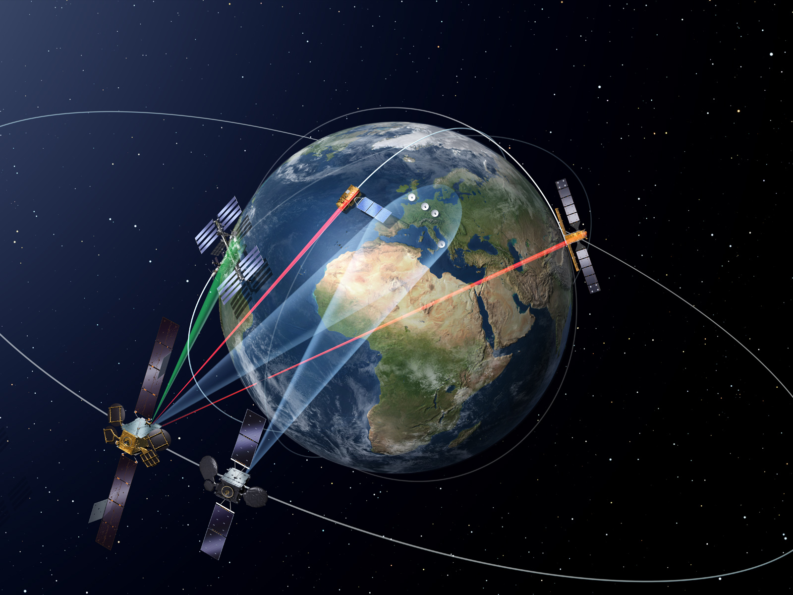
The EDRS concept works by connecting laser terminals flying on low Earth orbit satellites with relay nodes stationed high above in geostationary orbit, a range of up to 28,000 miles (45,000 kilometers).
The laser system allows data to stream from Earth observation satellites to the EDRS network at up to 1.8 gigabits per second, about 90 times faster than a typical modern Internet connection, according to Dudok.
“It is like if you were driving a sports car in Europe, and you were pointing your beam at a 2 euro coin in New York,” Dudok said. “This is where the trick comes in. You have to point it very accurately, and you have to follow the low Earth orbit observation satellite otherwise you cannot keep the connection up.”
The EDRS satellites then transmit the data to ground stations in Germany, Belgium, or Britain for dissemination to end users. Another ground site in Italy is also planned.
The data relay system also allows ground controllers to send instructions to low Earth orbit satellites when they are out of range of terrestrial communications stations.
Europe’s Earth observation satellites currently beam imagery to ground stations in the polar regions. The spacecraft only pass over the radio receivers for about 10 minutes during each 90-minute orbit, and it takes longer to pass the satellite data to users than if the imagery came directly to Europe from space.
Vaissiere said a market assessment jointly conducted by ESA, the European Commission and Airbus Defense and Space showed that the commercial value of satellite data acquired and delivered to users within one hour is three times the value of data more than three hours old.
Officials said the goal of EDRS is to reduce the latency in Sentinel satellite imagery to as little as 15 minutes.
“EDRS is made to serve Europe,” Vaissiere told reporters Jan. 15. “Time critical data is not just of use to commercial operators. The old ways of transmitting data are fast becoming outdated, and this is reflected in the demands of new users for new services.”
European border security forces could also benefit from the more rapid dissemination of Earth imagery from space.
Satellite imagery from the Sentinel spacecraft does not have the resolution and coverage required to help track the influx of refugees into Europe from the Middle East and North Africa, according to Volker Liebig, director of ESA’s Earth observation program.
Liebig said many migrants are crossing the Mediterranean Sea on small inflatable boats too small to be detected by the Sentinel satellites, but the images could show masses of refugees on beaches waiting to depart for Europe.
One way the EDRS network could aid Europe’s response to the refugee crisis is to speed up video relay from surveillance drones tasked with surveying European shores.
Dudok said Airbus Defense and Space plans a demo later this year on a new laser communications terminal tailored to fly on airplanes.
“From the second half of this year, we will be able to offer a product that can be used on drones — on planes — and make connections to EDRS,” Dudok said.
“A satellite, once it’s launched, it’s a rather stable platform,” Dudok said. “In an environment where you have engines and things like that, the vibrations are different. We have to verify that we can provide an optical link between such a flying plane and a satellite, which is a challenge.”
The EDRS program is branded the SpaceDataHighway, and Airbus intends to sell capacity in the commercial market, with an initial emphasis on airborne drones, or UAVs.
But the European Commission’s Sentinel 1 and Sentinel 2 satellites are the anchor customers for EDRS. The International Space Station will have the ability to send video and other data through the European data relay system in 2018, and future Earth observing spacecraft could be designed to communicate via laser, according to ESA.
The space station’s primary communications link with the ground is through NASA’s Tracking and Data Relay Satellite, or TDRS, network. Satellites for the TDRS fleet started launching in the 1980s, and the satellites now offer worldwide coverage.
The TDRS system relies on conventional radio links with the space station and other satellite users, and NASA plans to launch its first laser communications demo package to geostationary orbit by 2019.
NASA currently operates a space-to-ground laser test package aboard the space station, and the U.S. space agency demonstrated a laser communications device aboard a probe orbiting the moon in 2013.
“I think you cannot really, today, compare TDRS with EDRS,” Vaissiere said. “EDRS is using a very modern laser communications technology. It has much higher performance… It offers much more, I would say, than TDRS.”
The laser terminal on Eutelsat 9B, called EDRS A, will reach Europe, Africa, Latin America, the Middle East and parts of the east coast of North America.
The second EDRS station, called EDRS C, will be positioned in geostationary orbit at 31 degrees east longitude, giving it more coverage of Asia and the Indian Ocean.
Airbus and ESA hope to deploy a third EDRS node over the Asia-Pacific by 2020 to give the system global coverage, but that plan hinges on more funding.
Email the author.
Follow Stephen Clark on Twitter: @StephenClark1.