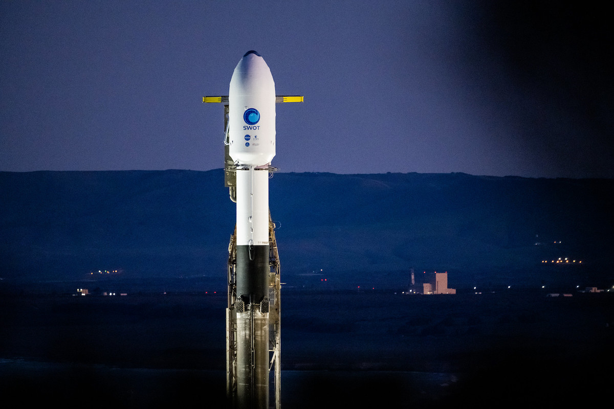
A French-built satellite equipped with an innovative U.S.-made radar instrument is buttoned up for blastoff aboard a SpaceX Falcon 9 rocket Friday from California, kicking off a mission to investigate the link between Earth’s water cycle and our planet’s changing climate.
The Surface Water and Ocean Topography, or SWOT, satellite is set for liftoff from Vandenberg Space Force Base, California, at 3:46:47 a.m. PST (6:46:47 a.m. EST; 1146:47 GMT) at the top of a Falcon 9 launcher. The Falcon 9, powered by nine kerosene-fueled Merlin 1D main engines, will fire off Space Launch Complex 4-East at Vandenberg, a military spaceport located roughly 140 miles (225 kilometers) northwest of Los Angeles.
The SWOT mission is a joint project developed by NASA and CNES, the French space agency, to make the first global survey of Earth’s surface water. The SWOT mission builds upon previous satellites that have measured rising sea levels and the height of ocean waves. But SWOT introduces a new instrument that can see finer details in the ocean’s surface roughness, and extend the water measurements to freshwater bodies like lakes and rivers.
“SWOT will provide nearly a complete view of the surface water on Earth,” said Ben Hamlington, a sea level researcher at NASA’s Jet Propulsion Laboratory. “Data collected by SWOT over the land, over the ocean, and where the land and ocean meet along our coastlines, is going to play a really important role in informing us about our daily lives and livelihoods.”
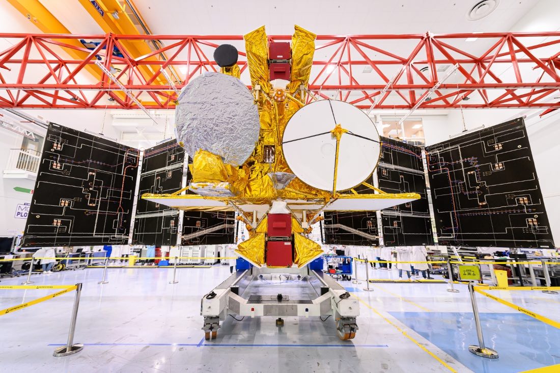
The Falcon 9 rocket will place the 4,850-pound (2,200-kilogram) SWOT satellite into an orbit about 532 miles (857 kilometers) above Earth at an inclination of of 77.6 degrees to the equator. SWOT will unfold its main science instrument, a two-wing radar interferometer, within the first week of its mission, then begin a six-month test campaign before beginning science operations in mid-2023.
“SWOT is a game changer,” said Tahani Amer, NASA’s program executive for the mission. “Water connects all of us and we’re very excited to share the data from SWOT.”
Forecasters at Vandenberg predict a 100% probability of good weather for liftoff Friday, when SpaceX has a 10-minute launch window available. The launch was delayed from Thursday to give engineers time to evaluate results of inspections on two of the Falcon 9’s main engines.
Julianna Scheiman, SpaceX’s director of civil satellite missions, said in a press conference Wednesday that technicians discovered the signature of moisture in two of the engines during launch preparations. Officials believed the moisture is likely from heavy rain that fell on the Falcon 9 when it was on the launch pad last week for an engine test-firing.
But SpaceX performed additional inspections on the two engines on the launch pad at Vandenberg to determine whether the moisture is from water intrusion or something else. Mission managers cleared the Falcon 9 for flight in a meeting Thursday.
“Technicians completed data reviews and the analysis of the presence of moisture in the engines, which was discovered during routine inspections on Dec. 14,” NASA said in a mission update on its website.
The first stage booster flying on the SWOT mission is designated B1071, and is set to make its sixth flight to space. The booster will fire its nine engines for more than two minutes, accelerating the Falcon 9 past the speed of sound with 1.7 million pounds of thrust. The initial trajectory from Vandenberg will take the rocket southwest from California’s Central Coast, then veer south with a left-hand turn, or “dogleg” maneuver, to line up with the SWOT satellite’s target orbital plane.
The Falcon 9’s first stage will shut off its nine engines, detach from the upper stage, and then reignite three of its engines for a “boost back” burn to reverse course and return to Landing Zone 4 at Vandenberg, just a quarter-mile from the rocket’s launch pad. After extending four aerodynamic grid fins, the booster will return to a propulsive landing on four deployable legs about seven-and-a-half minutes after liftoff.
The upper stage, meanwhile, will continue downrange to place the SWOT satellite into a preliminary parking orbit with a six-minute firing of its single Merlin engine. The rocket will coast over Antarctica and head northbound over the Indian Ocean before lighting its engine again 43 minutes into the mission for a brief burn to circularize its orbit at about 532 miles altitude, with an inclination of 77.6 degrees to the equator.
The SWOT spacecraft will separate from the Falcon 9’s upper stage about 52 minutes after liftoff. Ground teams in France will be on standby to receive the first radio signals from the satellite, and hope to confirm the extension of power-generating solar panels on the SWOT spacecraft soon after it arrives in orbit.
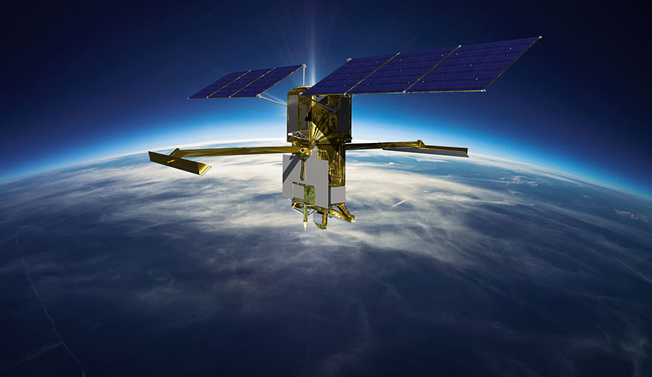
The SWOT mission builds on a series of U.S.-French satellites that have tracked rising sea levels and measured ocean wave heights since 1992. But SWOT introduces a new type of instrument, a Ka-band radar interferometer, with improved precision and a broader field of view than altimeters on older oceanography satellites.
The Ka-band radar interferometer, called KaRIn, consists of two antennas mounted on booms 33 feet (10 meters) apart, about half the length of a tennis court. One of the downward-facing antennas will transmit radar pulses, and both antennas on the instrument will measure the reflected radar signals that bounce off Earth’s surface. Scientists can derive the height of water levels in oceans, lakes, and rivers from the tiny difference in the time the reflected signals arrive at each antenna.
“These antennas have to be kept extremely stable and pointed at the same place on the Earth within a few microns, which is smaller than a human hair,” said Parag Vaze, SWOT project manager at NASA’s Jet Propulsion Laboratory. “The radar sends electromagnetic pulses from one antenna that reflect off the surface of the Earth and are received by both antennas as the same time. This provides a very precise measurement of the height using a triangulation technique called interferometry. That lets us create a 2D map of the surface water.”
Four cameras on the SWOT satellite will take pictures of the spacecraft’s solar arrays and radar antenna deployment sequence, which is expected to take about four days and should be complete around eight to nine days after launch, Vaze said.
“We’re expecting to have some beautiful imagery, and also a movie of the antenna deployment in particular,” Vaze said. “We are expecting it to be a nice end of year present.”
SWOT will fire its small maneuvering thrusters to raise its orbit to an altitude of 553 miles (891 kilometers) before commencing science observations next year. Scientists will calibrate the radar interferometer by comparing its results to reference measurements from previous oceanography satellites.
“The measurement system is complex, demanding extraordinary stability of the instrument and precision control of the large spacecraft, making SWOT a very challenging mission,” said Lee-Lueng Fu, SWOT’s project scientist at JPL. “SWOT will cover the world between 78 degrees north and 78 degrees south every 21 days, providing a high definition view of the surface water and ocean topography.”
Instead of collecting data points on sea level and wave height in line with the satellite’s ground track, as previous oceanography satellites did, SWOT’s instrument will make measurements in a swatch 75 miles (120 kilometers) wide as it circles Earth every hour-and-a-half. SWOT’s measurements will be sharper than those from older oceanography satellites, which were limited to gathering data on sea level and waves in the open ocean.
SWOT will have the resolution to measure the water levels in lakes and reservoirs, rivers, and in ocean waters closer to coastlines. The finer detail in data from SWOT will enable scientists to observe small-scale eddys where the ocean absorbs heat from the atmosphere.
“Only SWOT will be able to see the small eddys and fronts that are responsible or taking heat from the atmosphere,” Fu said. “These are the oceanic analogs of thunderstorms, creating intense vertical motions, drawing down the heat from the atmosphere and storing it in the deep ocean. This new information will help improve ocean models for predicting the ocean’s capacity in the future to continue absorbing heat to regulate climate change.”
The data from SWOT will be distributed worldwide for free, helping climate researchers, water management agencies, and disaster preparedness organizations track the effects of climate change, monitor scarce water resources, and respond to floods and droughts.
“The observation of surface water on land is what we need to assess the budget of freshwater,” Fu said. “In a warming climate, the Earth’s water cycle is accelerating, making water resources difficult to track and manage. Where is the water? Where does it come from? And then where does it go? These are questions we are not equipped to answer because the world’s rivers and lakes are poorly sampled in many places.
“SWOT will make a quantum jump by making observations from space to create a global inventory of water resources,” Fu said. “Water is also a source of hazards. If the water budget is out of balance, we’ll have either floods or drought. SWOT data will help us improve monitoring and forecasts of such perils.”
“SWOT data are going be used to monitor drought conditions, improve flood forecasts, monitor reservoir volume, and assess river flow,” Hamlington said.
Aside from the radar interferometer payload, SWOT carries a European-made radar altimeter similar to instruments flown on the Jason family of ocean monitoring satellites. Most recently, European and U.S. scientists teamed up to develop and launch the Sentinel-6 Michael Freilich satellite in 2020 to continue the continuous sea level and wave height data record from the Jason series of ocean altimetry satellites.
SWOT has a NASA-provided microwave radiometer instrument to correct for errors in the radar interferometer signals caused by water vapor in Earth’s atmosphere. And crucially, the satellite carries equipment to allow ground teams to determine its exact position in space with a precision of just 1 centimeter, according to Thierry Lafon, SWOT’s project manager at CNES.
The satellites’s science payload will generate a terabyte of data per day, Vaze said. SWOT will transmit the data to the ground with an X-band communications system.
Thales Alenia Space built the SWOT satellite its it factory in Cannes, France. NASA shipped the U.S.-made radar interferometer payload from JPL in California to the Thales satellite assembly plant in France, then the entire spacecraft was transported back to California in October on a U.S. military C-5 cargo plane to begin final launch preparations.
An independent panel of scientists identified the SWOT mission as a high priority in a 2007 decadal survey report, prompting NASA and CNES to commit to funding the project.
The SWOT mission has cost nearly $1.2 billion to develop, build, and launch. About two-thirds of the funding has come from NASA, and most of the remainder of the budget was provided by the French government. The UK Space Agency and Canadian Space Agency also supplied smaller contributions to the mission.
Email the author.
Follow Stephen Clark on Twitter: @StephenClark1.