The next Landsat observatory has been mounted on top of a United Launch Alliance Atlas 5 rocket in California for liftoff Sept. 27, continuing an unbroken record of Earth observations to track urban sprawl, water usage, tropical deforestation, retreating glaciers, and more over the last half-century.
Landsat 9 is the next in a series of land imaging missions launched since 1972, tracking nearly 50 years of city growth, climate change, and trends in use of lands for agriculture and infrastructure.
“We are days away from launching our ninth Landsat mission,” said Karen St. Germain, director of NASA’s Earth science division. “The Landsat program spans nearly 50 years and is a cornerstone of our understanding of Earth’s surface.
“Each satellite in the Landsat program has captured increasingly sophisticated data and imagery documenting Earth’s changing landscapes, and increasing our understanding of the planet on regional, national and global scales,” St. Germain said in a recent press conference on the Landsat 9 mission.
“Landsat data informs a wide range of decisions related to managing crop health and water resources,” she said. “These are critical decisions to mitigate global issues like regional famine or food scarcity in an era of accelerating climate change.
“This data is essential to global aid agencies, first responders here in the United States, policymakers are every level, major agricultural producers, and individual people, from farmers and ranchers to urban planners,” St. Germain said.
The Landsat program is a joint effort between NASA and the U.S. Geological Survey, with NASA responsible for spacecraft development and launch services. The USGS is in charge of ground systems and the Landsat data archive, and will operate the Landsat 9 mission after launch.
The Landsat 9 satellite is the next in a series of land imaging missions launched since 1972, collecting views from space of urban sprawl, tropical deforestation, retreating glaciers, and changes in coral reefs, crops, and tectonic faults.
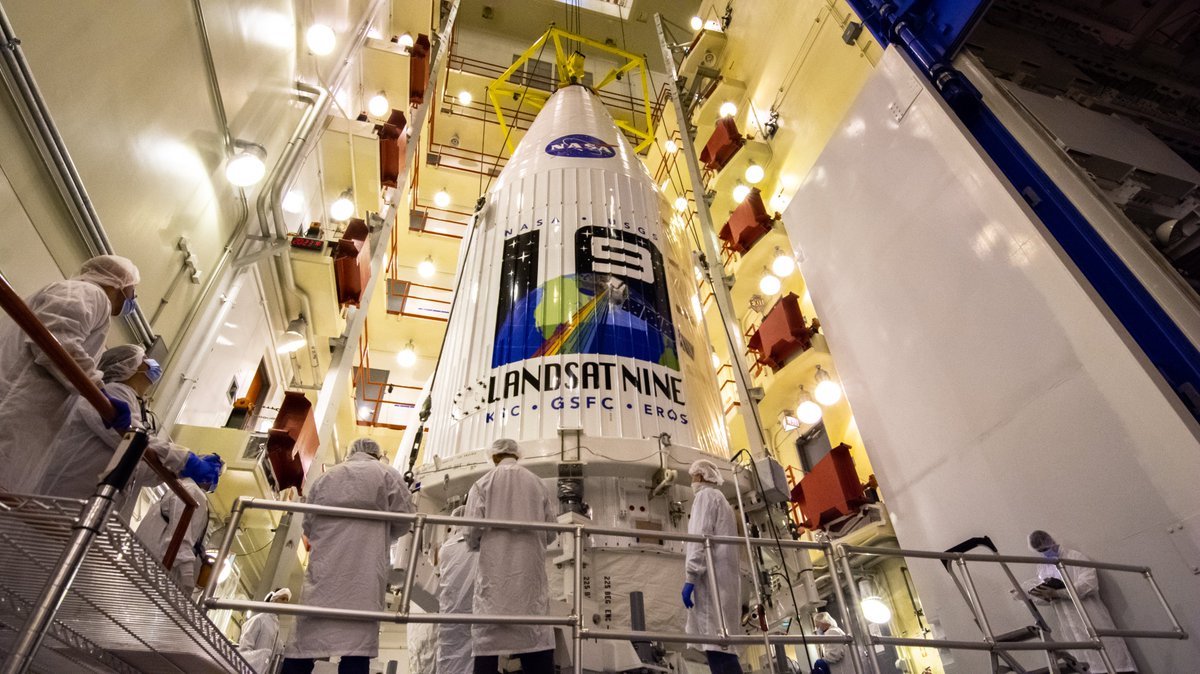
In recent weeks, technicians at Vandenberg Space Force Base in California have loaded propellant into the Landsat 9 spacecraft and closed the satellite inside the nose cone of its Atlas 5 rocket.
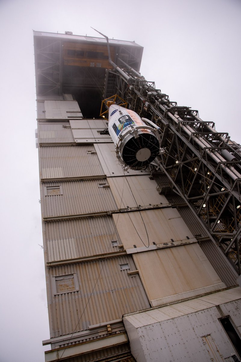
On Sept. 15, teams hoisted the 5,981-pound (2,713-kilogram) Landsat 9 spacecraft on top of the Atlas 5 rocket on Space Launch Complex 3-East at Vandenberg.
The transfer of Landsat 9 satellite to the launch pad was delayed several days by the liftoff last week of a SpaceX Falcon 9 rocket from a nearby facility at Vandenberg. That forced NASA and ULA officials to delay the launch of Landsat 9 from Sept. 23 to Sept. 27.
Last month, officials delayed the Landsat 9 launch from an earlier target date of Sept. 16 after problems with the delivery of liquid nitrogen to Vandenberg. Trucks typically used for the nitrogen shipments were repurposed for liquid oxygen transportation to hospitals due to higher demand caused by the coronavirus pandemic.
Gaseous nitrogen, converted from cryogenic liquid form, is used by ULA in pre-launch testing.
Last year, NASA said the Landsat 9 launch was delayed from April 2021 to September 2021 after inefficiencies caused by the pandemic slowed assembly and testing of the spacecraft.
But Landsat 9’s launch is less than a week away now. Liftoff from the SLC-3E launch pad at Vandenberg is scheduled for 11:11 a.m. EDT (2:11 p.m. EDT; 1811 GMT) on Monday, Sept. 27.
An Atlas 5 rocket, flying in its basic configuration with no solid-fueled boosters, will fly south from Vandenberg over the Pacific Ocean. The Atlas 5’s first stage will shut down its Russian-made RD-180 engine about four minutes into the mission. An Aerojet Rocketdyne RL10 engine on the rocket’s Centaur upper stage will fire for 12 minutes to inject the Landsat 9 satellite into orbit.
After deployment of Landsat 9, the Centaur stage will reignite its engine two times to maneuver into a different orbit for separation of four small CubeSat rideshare payloads.
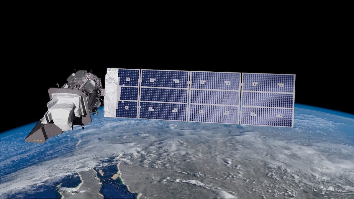
The newest Landsat satellite, built by Northrop Grumman, will fly around Earth in a polar orbit 438 miles (705 kilometers) above the planet, surveying the globe every 16 days in image swaths 115 miles (185 kilometers) wide.
Each pixel in the images captured by Landsat 9’s Operational Land Imager 2, or OLI 2, instrument will be about 100 feet (30 meters) across, about the size of a baseball diamond. Landsat 9’s other instrument — the Thermal Infrared Sensor 2, or TIRS 2 — can resolve features about 330 feet (100 meters) in size, roughly the length of a football field.
The $885 million Landsat 9 mission is based on the Landsat 8 satellite, which launched in 2013. The Obama administration directed NASA and the USGS to develop Landsat 9 in 2015, using new copies fo the OLI and TIRS instruments on Landsat 8.
The Landsat 8 satellite, designed for a five-year lifetime, remains operational. Landsat 8 and 9, working in tandem, will cover all of Earth’s land masses every eight days, according to Jeff Masek, NASA’s project scientist for the Landsat 9 mission.
“This frequency is really critical for assessing change, both for within a single year and between years,” Masek said.
Landsat 9 will also work in concert with other land imaging satellites, such as the European Sentinel 2 missions, to extend the continuous global coverage of land masses since the launch of Landsat 1 in 1972.
“When we further add in the data from the similar Sentinel 2A and 2B (satellites), we can get that refresh down to two to three days,” St. Germain said.
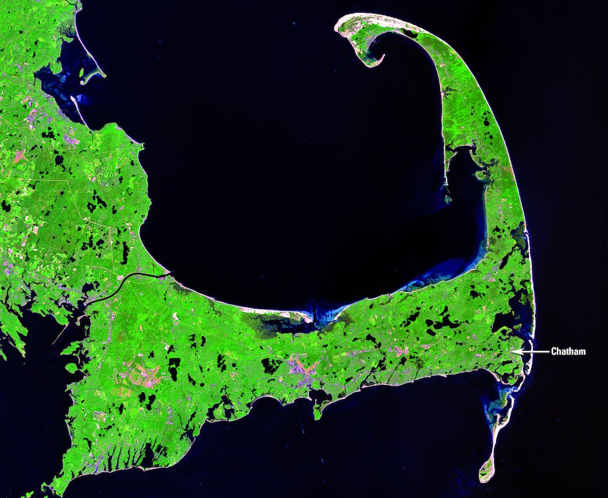
The Landsat data archive catalogs changes in land cover, water quality, glacier flow, and other properties of Earth’s surface, according to NASA. The thermal infrared data from Landsat satellites provide information on irrigation and water usage.
Scientists and forest managers use Landsat data to measure the impact of wildfires.
“I like to think of Landsat as something like a Swiss Army knife,” Masek said. “Out of one basic set of observations or measurements, we feed a whole range of different Earth science applications.
“It’s key role is to track both human-induced and natural changes to the land environment to better support land management decision-making,” Masek said. “And along the way, we’re able to assemble and visualize an amazing history of how the planet has changed over the last half-century.”
The first Landsat satellite launched in 1972. Here’s a list of the Landsat missions to date:
• Landsat 1: Launched July 23, 1972, on a Delta 900 rocket. Operational until January 1978.
• Landsat 2: Launched Jan. 22, 1975, on a Delta 2910 rocket. Operational until February 1982.
• Landsat 3: Launched March 5, 1978, on a Delta 2910 rocket. Operational until March 1983.
• Landsat 4: Launched July 16, 1982, on a Delta 3920 rocket. Operational until 1993.
• Landsat 5: Launched March 1, 1984, on a Delta 3920 rocket. Operational until 2013.
• Landsat 6: Launched Oct. 5, 1993, on a Titan 2 rocket. Did not reach orbit due to apogee propulsion system failure.
• Landsat 7: Launched April 15, 1999, on a Delta 2 rocket. Remains operational.
• Landsat 8: Launched Feb. 11, 2013, on an Atlas 5 rocket. Remains operational.
Landsat satellites have detected changes in the health and coverage of forests, and observed the impacts of climate change of ecosystems around the world. Masek said the Landsat satellites have noticed increased plant cover and melting of ice caps at higher latitudes due to warming temperatures.
“We can look at the types of crops being grown, we can measure their health, we can look at agricultural productivity,” Masek said. “We can also use the surface temperature measurements from TIRS, and energy budget models, to measure crop water consumption, which is an important application in the western U.S.”
While Landsat satellites are focused on land imaging, observations can also track changes in lake sizes, water quality, and help with the early detection of algal blooms, according to Masek.
“New applications are emerging all the time, so with the launch of Landsat 9, the user community, the science community, is absolutely looking forward to this launch, and for Landsat 9 to join the Landsat constellation,” Masek said.
NASA says the Landsat archive includes more than 8 million images captured since 1972.
David Applegate, acting director of the USGS, said the Landsat 8 and 9 satellites will combine to downlink nearly 1,500 images per day for distribution to hundreds of thousands of users around the world, free of charge.
“Much like GPS and weather data, Landsat data are used every day to help us better understand our dynamic planet,” Applegate said.
Like Landsat 8, the new Landsat 9 spacecraft is has a design life of five years, but carries enough fuel to operate for at least a decade.
“If you put the two satellites side by side, they would look very similar,” said Del Jenstrom, Landsat 9 project manager at NASA’s Goddard Space Flight Center. “Like Landsat 8, we have two instruments. We have the Thermal Infrared Sensor 2, which we call TIRS 2, which is a two-band thermal imager, and we have the Operational Land Imager 2, OLI 2, which is a nine-band reflective imager with spectral coverage from visible to shortwave infrared.”
Jenstrom said the new satellites biggest improvement over Landsat 8 was to make changes to the TIRS 2 instrument, built in-house at Goddard. Engineers added more backup components to make the TIRS 2 instrument more reliable, and improved optics inside the sensor to correct an issue with stray light reaching the focal plane.
Teams on the ground compensated for Landsat 8’s stray light issue with changes to the way they process the imagery, but the underlying problem has been fixed for Landsat 9.
The OLI 2 instrument, supplied by Ball Aerospace, has two additional imaging bands to detect cirrus clouds and improve images of coastal waters. Jenstrom said the Landsat 9 satellite will downlink 14-bit data from OLI 2, compared with 12-bit data from OLI on Landsat 8, improving sensitivity by about 25%.
Landsat 9 also flies with a new generation of avionics and software. The satellite is also better shielded against orbital debris impacts and static charge build-up, according to Jenstrom.
Emerging commercial space capabilities, such as privately-funded Earth-imaging spacecraft, aren’t a replacement for the government-owned Landsat satellites, St. Germain said.
New commercial startups provide “additional science” and “additional observations” for Earth scientists, she said.
“They don’t today replicate or replace the kind of data we collect with Landsat, but they generally have complementary strengths and can augment our base of understanding,” St. Germain said.
“As an example, commercial systems, generally they can observe more often, but they generally don’t observe in all the wavelengths we need to do the work we do with Landsat,” she said. “And also those commercial systems often rely on systems like Landsat as an anchor for their calibration and stability.”
Email the author.
Follow Stephen Clark on Twitter: @StephenClark1.