|
|
||
|
|
||
|
NOAA-L continues environmental observations NASA FACT SHEET Posted: Sept. 19, 2000
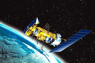
NOAA-L is the latest in the series of advanced TIROS-N spacecraft that provide a platform to support the environmental monitoring instruments for imaging and measuring the Earth's atmosphere, its surface and cloud cover. The polar-orbiting spacecraft serve as complementary satellites to the geosynchronous Geostationary Operational Environmental Satellites (GOES) system. Whereas the GOES satellites provide near-term data for the continental United States and Hawaii to NOAA's forecasters, the polar-orbiting spacecraft provide full global data for short- and long-range forecast models, climate modeling and various other secondary missions. Instruments on board the spacecraft monitor the entire Earth, providing atmospheric measurements of temperature, humidity, ozone and cloud images as they track weather patterns that affect global weather and climate. The satellites send millions of global measurements daily to NOAA's Command and Data Acquisition stations in Fairbanks, Alaska and Wallops Island, Va., and data processing center in Suitland, Md. These measurements add valuable information to forecasting models, especially for ocean areas, where conventional ground-based data is lacking. The spacecraft also provides a platform for the Search and Rescue Satellite Aided Tracking system, part of the COSPAS-SARSAT constellation. This international search and rescue system detects and locates emergency beacons transmitted from ships, aircraft and people in distress and has aided in saving thousands of lives.
NOAA-L will be launched aboard a Titan 2 expendable space launch vehicle from Vandenberg Air Force Base, Calif. The 10-minute launch window opens at 3:22 a.m. PDT. Separation of the spacecraft from its launch vehicle will occur about 394 seconds after launch.
The spacecraft was built by Lockheed Martin Space Systems Company. The instruments onboard NOAA-L include the Advanced Very High Resolution Radiometer (AVHRR/3), the High Resolution Infrared Radiation Sounder (HIRS/3), the Advanced Microwave Sounding Unit-A (AMSU-A1, A2), the AMSU-B, the Solar Backscatter Ultraviolet Radiometer (SBUV/2), the Space Environment Monitor (SEM/2) and the Data Collection System (DCS/2). In addition, it carries two search and rescue instruments, the Search and Rescue Repeater (SARR) and the Search and Rescue Processor (SARP). The AVHRR/3 is the primary imaging system and consists of visible, near infrared (IR) and thermal IR channels. The primary sounding suite flying on NOAA-L is the HIRS/3, AMSU-A and AMSU-B, which measure atmospheric temperature and humidity. The SBUV/2 instrument is both an imager and a sounder. As an imager, it produces total column ozone maps. As a sounder, it obtains and measures the ozone distribution in the atmosphere as a function of altitude.
|
Flight data file Vehicle: Titan 2 (G-13) Payload: NOAA-L Launch date: Sept. 20, 2000 Launch window: 1022-1032 GMT (6:22-6:32 a.m. EDT) Launch site: SLC-4W, Vandenberg AFB, Calif. Pre-launch briefing Launch timeline - Chart with times and descriptions of events to occur during the launch. Titan 2 - Description of the former ICBM missile converted to a space launch vehicle. |
|||||||||||||||||||||||
|
MISSION STATUS CENTER |
||||||||||||||||||||||||