|
 |
|
||||
|
|
||||
|
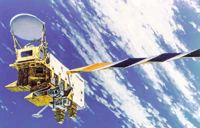
Aqua instrument package NASA PRESS KIT Posted: May 1, 2002 Aqua will help us to better understand and protect our home planet by answering science questions and meeting science goals through its suite of six high performance instruments. Each instrument is designed to collect measurements on a different aspect of the Earth system - areas vital for achieving a holistic view of our home planet.
Atmospheric Infrared Sounder (AIRS) AIRS will observe and characterize the entire atmospheric column from the surface of Earth to the top of the atmosphere. This sensor will provide data on Earth's surface and atmospheric temperature, humidity, clouds, and the ability of Earth's surface to radiate energy back into space. AIRS also will measure ozone and other greenhouse gases. These data will help researchers increase their understanding of Earth's global water and energy cycles, climate variation and trends, and the response of the climate system to increased greenhouse gases. The result will be more reliable climate prediction, improved weather forecasts, a better understanding of factors influencing air quality and consequently a better ability to reduce economic and human losses from natural hazards. AIRS data will contribute to NASA's mission to better life here on Earth through our understanding of the Earth system. The AIRS instrument is one of three microwave sounding instruments aboard NASA's Aqua spacecraft. AIRS, in combination with the Advanced Microwave Sounding Unit (AMSU) and the Humidity Sounder for Brazil (HSB), represents the most advanced and accurate atmospheric sounding system ever deployed in space. This suite of sounding instruments is expected to become the pathfinder for the National Oceanic and Atmospheric Administration's (NOAA) future operational sounding system. The NOAA National Centers for Environmental Prediction currently uses land-launched weather balloons and satellite data to update forecasts every six-hours. These forecasts are accurate to within 1.1 to 1.3 degrees Kelvin (1.98 to 2.34 degrees Fahrenheit) in regions with good weather balloon coverage. However, the balloons, which measure temperature, humidity and pressure and transmit information to a ground receiver, do not observe the 75 percent of the world covered by oceans and are scarce in Africa, Asia and South America. Obtaining more accurate, detailed satellite information at more frequent sampling intervals is key to improving weather forecasting. Every 2.67 seconds, AIRS will "plumb" the atmosphere at multiple depths for temperature and humidity. Aqua will observe the Earth and measure the infrared brightness of the atmosphere in many wavelengths. Each wavelength of light emphasizes a particular height in the atmosphere. By having multiple infrared detectors, each sensing a particular wavelength, a temperature profile, or "sounding," of the atmosphere can be made. Unlike previous space instruments that had only 15 detectors, AIRS has 2,378 detectors, or channels, greatly improving accuracy and vertical resolution. At the heart of AIRS is an advanced, high-resolution spectrometer that measures Earth's infrared spectral region from 3.75 to 15.4 micrometers. As Aqua moves along its flight path, AIRS sweeps the ground below, creating a scan "swath" extending roughly 800 kilometers (497 miles) on either side of the ground track. Each infrared scan produces 90 "footprints" across the flight track, each viewing an area approximately 13.5 kilometers (8.4 miles) in diameter directly below the spacecraft at the Earth's surface. During each scan, AIRS collects 2,378 spectral samples, measuring the complete infrared spectrum. Global coverage is obtained twice daily, except close to the equator. Infrared energy from Earth's surface and atmosphere enters the AIRS instrument and is directed into the infrared spectrometer and visible/near-infrared photometer. Within the spectrometer, it is further directed into 11 different slits‹essentially creating 11 different spectrometers all viewing the same area. The energy from each slit is then dispersed across AIRS' state-of-the-art focal plane assembly, which consists of an array of mercury-cadmium-telluride (HgCdTe) detectors, each of which views a unique wavelength. AIRS' visible/near-infrared photometer has a field of view of approximately 2.3 kilometers (1.43 miles) on the ground. It is aligned with the infrared spectrometer to allow simultaneous visible and infrared scene measurement. The photometer, which uses optical filters to define four spectral bands in the 0.4 to 1.0 micrometer region, provides a diagnostic imaging capability for the presence of low-level clouds. AIRS will provide detailed observations over most of Earth at intervals of about 50 kilometers or 31 miles ‹ about three times better spatial resolution than currently available from satellite observations. This improvement will enable AIRS to detect strong, narrow storms that previously may have gone undetected. AIRS will provide multiple observations at each point, revealing many subtleties that will help improve the weather forecasts of operational agencies. Within a few months of launch, AIRS will provide data to weather forecasters around the world. The program is working with several institutions, including NASA's Data Assimilation Office, NOAA and its National Centers for Environmental Prediction, the European Center for Medium-Range Weather Forecasts, the Japan Meteorological Administration, the Australia Bureau of Meteorology, the British Meteorological Office and the Meteorological Service of Canada. AIRS will enable an improvement in the useful range of weather forecasts by two to three days. The airline, transportation, agriculture and construction industries will all be major benefactors of improved weather forecasts. NASA is dedicated to developing advanced technologies that will help better life here on Earth while providing the tools needed to explore the universe. AIRS measures 116.5 by 80 by 95.3 centimeters (45.9 by 31.5 by 37.5 inches) stowed and 116.5 by 158.7 by 95.3 centimeters (45.9 by 62.5 by 37.5 inches) deployed and has a mass of 177 kilograms (390.2 pounds). AIRS was built by BAE SYSTEMS for NASA's Jet Propulsion Laboratory, Pasadena, Calif. Other members of the AIRS contractor team include TRW, Matra Marconi Space, and Aerojet. Advanced Microwave Sounding Unit (AMSU) The AMSU sensor has 15 channels, 12 of which are predominantly for temperature soundings and three of which are for atmospheric water vapor and precipitation measurements. The AMSU data will have horizontal resolutions directly below the satellite of 40.5 km (25.1 miles). The AMSU and Humidity Sounder for Brazil (discussed below) measure at microwave wavelengths and complement the infrared measurements of the AIRS sensor. The capability to acquire microwave measurements in addition to infrared measurements increases the range of conditions under which accurate science results can be obtained. AMSU was built by Aeroject under contract with NASA Goddard. Humidity Sounder for Brazil (HSB) This sounding instrument will help improve global weather forecasting by providing data where radiosonde data is scarce, as is the case in the Southern Hemisphere. HSB also will help in the understanding of the Brazilian rainforest system by providing scientific data to the scientists of National Institute for Space Research (INPE), who constantly monitoring the rainforest environment through satellite imagery. The HSB instrument aboard Aqua is the result of a memorandum of understanding signed by NASA and the Brazilian Space Agency (AEB) in December of 1996. The development of the instrument has been coordinated by the INPE and is sponsored by AEB. The HSB was provided to the Aqua mission by INPE with the prime contractor being Matra Marconi Space. Clouds and the Earth's Radiant Energy System (CERES) The energy received from the Sun is at short wavelengths, while the energy emitted by the surface of the Earth, the atmosphere and clouds is at long wavelengths. Greenhouse gases in the atmosphere absorb the long wavelength energy or heat emitted by the Earth. Increases in the amounts of greenhouse gases produced by both natural processes and human activities can lead to a warming of the Earth's surface. Such changes may, in turn, alter the planet's daily weather and climate. Clouds and small particles in the atmosphere called aerosols also reflect some sunlight back into space. Major sources of aerosols include windblown dust, emissions from the burning of fossil fuels, such as gasoline, and the burning of forests and agricultural fields. CERES will measure energy at the top of the atmosphere, within the atmosphere and at the Earth's surface. Using information from very high resolution cloud imaging instruments aboard Aqua, CERES also will determine cloud properties, including altitude, thickness, and the size of cloud particles. All of these measurements are critical for advancing the understanding and protection of the Earth's total climate system and the accuracy of climate prediction models. One of the most intriguing questions facing climate modelers today is how clouds affect the Earth's climate and vice versa. The U.S. Global Change Research Program, which NASA is a member of, classifies understanding the role of clouds and the Earth's energy budget as one of its highest scientific priorities. Understanding cloud effects requires a detailed knowledge of how clouds absorb and reflect sunlight, as well as how they absorb and re-emit outgoing heat emitted by the planet. For example, low, thick clouds primarily reflect incoming solar energy back to space causing cooling. Thin, high clouds, however, primarily trap outgoing heat and produce warming. To date, satellite studies have found that clouds have an overall cooling effect on the Earth. Water vapor in the atmosphere also impacts our daily weather and climate, though scientists are only beginning to understand how this complex mechanism works. Water vapor acts like a greenhouse gas and absorbs outgoing heat to warm the Earth. Since water vapor also condenses to make clouds, additional water vapor in the atmosphere also may increase the amount of clouds. CERES consists of two broadband scanning radiometers that measure reflected sunlight, Earth-emitted thermal radiation, and total radiation. Scientists will use CERES observations to study the energy exchanged between the Sun; the Earth's atmosphere, surface and clouds; and outer space. The CERES Aqua instruments will be the fourth and fifth CERES instruments in orbit. NASA launched the first CERES instrument aboard the Tropical Rainfall Measuring Mission (TRMM) satellite in November 1997. Results of the TRMM mission show that the first CERES provided better measurement capabilities than any previous satellite instrument of its kind. Two other CERES instruments are currently orbiting the Earth on NASA's Terra spacecraft, launched in late 1999. Early CERES results from Terra give new insights into the effects of clouds on climate and how the climate system changes from decade to decade. The CERES instruments aboard the Terra and Aqua satellites will provide global coverage of energy radiated and reflected from the Earth. Scientists will use measurements from both Terra and Aqua's orbits to improve observations of the daily cycle of radiated energy. NASA's Langley Research Center manages the CERES mission. The CERES instrument was built by TRW Space & Electronics Group in Redondo Beach, Calif. Advanced Microwave Scanning Radiometer for Earth Observing Satellite AMSR-E will measure Earth's environment in support of several global change science and monitoring efforts. Precipitation and evaporation are extremely important processes to understand. Through provision of water to the biosphere via precipitation and as an air conditioning agent that removes excess heat from the surface (via evaporation), these processes contribute toward making Earth habitable. Understanding rainfall is vital to our understanding and protecting our home planet. AMSR-E will measure rainfall rates over both lands and oceans. Over the oceans, the AMSR-E microwave frequencies can probe through smaller cloud particles to measure the microwave emission from larger raindrops. AMSR-E will provide sensitivity to oceanic rain rates as high as 50 mm/hr (about 2 inches per hour). Over land, AMSR-E can measure the scattering effects of large ice particles, which later melt to form raindrops. In this instance, these measurements are converted to rain rates with the help of cloud models. Over the oceans, in addition to rain rates, AMSR-E will provide sea surface temperatures through most types of cloud cover. These measurements will supplement infrared-based measurements of sea surface temperatures that are currently restricted to cloud-free areas. Sea surface temperature fluctuations are known to have a profound impact on weather patterns across the globe, and the all-weather capability of AMSR-E may provide a significant improvement in our ability to monitor sea surface temperatures and the processes controlling them. The total integrated water vapor of the atmosphere also will be measured over the oceans. This variable is important in understanding how water is cycled through the atmosphere. Since water vapor is the Earth's primary greenhouse gas, and contributes the most to future projections of global warming, it is critical to understand how it varies naturally within the Earth system. The AMSR-E measurements of ocean surface roughness can be converted into near-surface wind speeds. These winds are an important determinant of how much water is evaporated from the surface of the oceans. Winds help to maintain the water vapor content of the atmosphere while precipitation continually removes it. AMSR-E cloud-water estimates over the ocean will help scientists determine if clouds, with their ability to reflect sunlight, increase or decrease under various conditions. This could be an important feedback mechanism that either enhances or mitigates global warming, depending on whether clouds increase or decrease with warming. Monitoring of sea-ice parameters, such as ice concentration, type, and extent, is necessary to understand how this frozen blanket over the oceans affects the larger climate system. Sea ice has the ability to insulate the water against heat loss to the frigid atmosphere above it, and at the same time the ability to reflect sunlight that would otherwise warm the oceans. The AMSR-E instrument will take advantage of the marked contrast in microwave emissions of sea ice and liquid water and these measurements will allow for the derivation of sea ice concentrations in both polar-regions. In much the same way as AMSR-E can see large ice particles in the upper reaches of rain systems, it also measures the scattering effects of snow-cover depth. These measurements are empirically related to snow-cover depth and water content based upon field measurements. Like sea ice, snow cover has a large influence on how much sunlight is reflected from the Earth. Snow also acts as a blanket, keeping heat from escaping from the underlying soil and allowing deep cold air masses to develop during the winter. It further provides an important storage mechanism for water during the winter months, which then affects how much surface wetness is available for vegetation and crops in the spring - important data for agricultural resource management. AMSR-E monitoring of snow cover will allow studies and monitoring of how snow-cover variations interplay with other climate fluctuations. In areas of very little surface vegetation, the AMSR-E sensor can identify the moisture content of soil. AMSR-E will provide data that will allow scientists to determine how useful low-frequency (6.9 GHz) microwave observations can be to monitoring surface wetness. Surface wetness is important for maintaining crop and vegetation health, and monitoring soil moisture on a global basis will allow drought-prone areas to be checked for signs of drought. AMSR-E will provide unprecedented detail and accuracy in the global, all-weather measurement of these variables and thereby will allow a more-complete understanding of climate variability, ultimately enabling better climate prediction. Moderate Resolution Imaging Spectroradiometer The MODIS instrument is part of the sensor package aboard NASA's Terra satellite and, in combination with Aqua, this instrument will yield simultaneous, congruent observations of high-priority atmospheric (cloud cover and associated properties), oceanic (sea-surface temperature and chlorophyll), and land-surface features (land-cover changes, land-surface temperature, and vegetation properties). The MODIS instrument employs a conventional imaging-radiometer concept, consisting of a cross-track scan mirror and collecting optics, and a set of linear detector arrays with spectral interference filters located in four focal planes. The optical arrangement will provide imagery in 36 discrete bands from 0.4 to 14.5 µm, selected for diagnostic significance in Earth science. MODIS instruments will provide daylight reflection and day/night emission spectral imaging of any point on the Earth at least every two days. The instrument is expected to make major contributions to the understanding of the global Earth system, including interactions between land, ocean, and atmospheric processes. The Moderate Resolution Imaging Spectroradiometer (MODIS), was built by Raytheon Santa Barbara Remote Sensing, under contract with Goddard Space Flight Center.
|
Flight Data File Vehicle: Delta 2 (7920-10L) Payload: Aqua Launch date: May 4, 2002 Launch time: 0954:58-1004:58 GMT (5:54:58-6:04:58 a.m. EDT) Launch site: SLC-2W, Vandenberg AFB, Calif. Satellite broadcast: GE-2, Transponder 9, C-band Pre-launch briefing Launch timeline - Chart with times and descriptions of events to occur during the launch. Orbit trace - Maps showing the ground track for the launch. Aqua - General overview of this NASA spacecraft. Science goals - Aqua's science objectives and mission goals. Delta 2 rocket - Overview of the Delta 2 7920-model rocket used in this launch. SLC-2W - The launch pad where Delta rockets fly from Vandenberg. Delta directory - See our coverage of preview Delta rocket flights. |
||||
|
MISSION STATUS CENTER |
|||||