|
 |
|
||||
|
|
||||
|
Defense Support Program U.S. AIR FORCE FACT SHEET Posted: February 10, 2004
The DSP constellation is operated from the Space Based Infrared Systems (SBIRS) Mission Control Station (MCS) at Buckley Air Force Base, Colo. The SBIRS program office at Los Angeles Air Force Base, Calif. plans to launch the two remaining satellites by 2005.
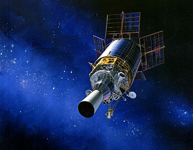
DSP evolution On November 6, 1970, the U.S. Air Force launched a classified satellite on a Titan IIIC rocket from Launch Complex 40 at Cape Canaveral Air Force Station, Florida. The secret mission of the spacecraft aboard the Titan was to provide early warning for Intercontinental Ballistic Missile launches from the Soviet Union and the People's Republic of China as well as Sea-Launched Ballistic Missiles near North America. That classified satellite became the first of 21 to be launched over the next 30 years with five major design changes that improved the reliability, capability and service life of the spacecraft. The original DSP used 2,000 lead-sulfide infrared detectors, weighed 2,000 pounds, had 400 watts of electrical power and a design life of 1.25 years. In the 1970s, the Air Force and industry contractor team upgraded the satellite to meet new mission requirements. As a result, the satellite's weight grew to 3,690 pounds, the power increased to 680 watts, the number of detectors increased by threefold to 6,000 and the design life improved to three years with a goal of five years. Some of the later spacecraft have operated for more than 10 years, with one satellite serving the nation for an astounding 18 years‹well past design lifetime. When fully deployed, a current generation DSP satellite is about 10 meters long and 6.7 meters in diameter. Numerous improvement projects have enabled DSP to provide accurate, reliable data in the face of evolving missile threats. The addition of a medium wavelength infrared capability provided enhanced missile warning mission utility. This upgrade marked the first space sensor application of mercury cadmium telluride infrared sensors‹the material of choice for today's infrared sensors. The current DSP spacecraft is more survivable than its predecessors, accommodates 6,000 detectors, uses 1,274 watts of power and weighs 5,200 pounds. Early in the program, TRW (now Northrop Grumman) engineers pioneered a "zero momentum" technique that allows the spacecraft to control its attitude with minimum fuel expenditure. They developed a mechanical solution called Inertial Properties Adjustment Device that enables the vehicle's spin axis to be fine-tuned‹saving large amounts of fuel. Recent technological improvements in sensor design include above-the-horizon capability for full hemispheric coverage and improved resolution. Increased on-board signal-processing capability improved clutter rejection. Enhanced reliability and survivability improvements were also incorporated. Over the last 33 years, there have been 21 satellite launches with five major design changes. These "blocks" of satellites are:
In 1995, the Air Force implemented a new data processing system called Attack and Launch Early Reporting to Theater (ALERT). ALERT's mission capability is now performed at the SBIRS MCS and provides improved warning of attack by short-range ballistic missiles against United States and allied forces overseas.
Launches and satellite operations After release from either the Titan or Delta, the satellite is boosted into an intermediate transfer orbit using an Upper Stage. During launch and early orbit, DSP satellites are under the control of the 1st Space Operations Squadron at Schriever Air Force Base. After launch, Air Force Space Command controllers at Schriever Air Force Base in Colorado gradually move the satellite into its geosynchronous operational parking slot over the equator. Within several days of the launch, a team comprised of specialists from the DSP program office, the Aerospace Corporation, and Northrop Grumman begin on-orbit checkout of the satellite. The systems checkout and test can take up to 30 days before the satellite is deemed operational and turned over to Air Force Space Command for use. The 21st Space Wing at Peterson AFB, Colo., operates the DSP satellites and reports warning information to the North American Aerospace Defense Command and U.S. Strategic Command early warning centers in Cheyenne Mountain (near Colorado Springs). In recent years, scientists have been developing methods to use DSP's infrared sensor as part of an early warning system for natural disasters like volcanic eruptions and forest fires. With the DSP satellite constellation scanning nearly all of the earth's surface once every few seconds, emergency response agencies could have a tremendous tool for early detection and warning of potential natural disasters. DSP has been used by researchers at The Aerospace Corporation to develop portions of a Hazard Support System that will aid public safety in the future. The development and acquisition of the Defense Support Program satellites is managed by the Space Based Infrared System Program Office at the Air Force Space and Missile Systems Center (Air Force Space Command) at Los Angeles Air Force Base, Calif. The Lockheed Martin Astronautics Titan launch vehicle, The Boeing Company's Inertial Upper Stage and the Northrop Grumman built satellite are integrated at Cape Canaveral Air Station Florida by the 45th Space Wing's 3rd Space Launch Squadron.
Defense Support Program satellite data Contractor team: Northrop Grumman Space Technology and Northrop Grumman Electronic Systems Orbital Altitude: 35,780 kilometers // 19,320 nautical miles // 22,233 statute miles Power Plant: Solar arrays generating 1,485 watts of power (satellite uses 1,274 watts) Height: 32.8 ft. (10 meters) on orbit; 28 ft. (8.5 meters) at launch Weight: 2,386 kilograms // 5,250 pounds Diameter: 22 ft. (6.7 meters) on orbit; 13.7 ft. at launch First Deployed: November 6, 1970 Last Launch: Aug 6, 2001 Unit Cost: Approximately $256 million
|
|
||||
|
MISSION STATUS CENTER |
|||||