|
|
||
|
|
||
|
Defense Support Program NU.S. AIR FORCE FACT SHEET Posted: May 7, 2000
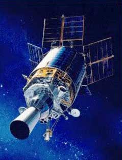
The Air Force DSP satellites orbit the earth about 35,780 kilometers over the equator in geosynchronous orbits. DSP satellites use infrared sensors to detect heat from missile and booster plumes against the earth's background. In 1995, the Air Force implemented a new data processing system called Attack and Launch Early Reporting to Theater (ALERT). This ALERT capability provides improved warning of attack by short-range ballistic missiles against United States and allied forces overseas. The Defense Support Program grew out of the successful 1960s space-based infrared Missile Defense Alarm System known as MiDAS. The Air Force Space and Missile Systems Center declassified this ballistic missile early warning satellite system program Nov. 30, 1998. Between 1960 and 1966, there were 12 MiDAS launches deploying four different types of increasingly sophisticated sensors ‹ sensors which led the way to the development, launch and use of the DSP. The Air Force launched the first DSP satellite November 6, 1970 to provide early warning for InterContinental Ballistic Missile launches from the Soviet Union and the People's Republic of China as well as Sea-Launched Ballistic Missiles near North America. The original DSP used 2,000 lead-sulfide infrared detectors, weighed 2,000 pounds, had 400 watts of electrical power and a design life of 1.25 years. In the 1970s, the Air Force and industry contractor team upgraded the satellite to meet new mission requirements. As a result, the satellite's weight grew to 3,690 pounds, the power increased to 680 watts, the number of detectors increased by threefold to 6,000 and the design life improved to three years with a goal of five years. Some of the later spacecraft have operated for more than 10 years ‹ well past design lifetime. When fully deployed, a current generation DSP satellite is about 10 meters long and 6.7 meters in diameter. Early in the program, TRW engineers pioneered a "zero momentum" technique that allows the spacecraft to control its attitude with minimum fuel expenditure. They developed a mechanical solution called Inertial Properties Adjustment Device that enables the vehicle's spin axis to be fine-tuned ‹ saving large amounts of fuel. Recent technological improvements in sensor design include above-the-horizon capability for full hemispheric coverage and improved resolution. Increased on-board signal-processing capability improves clutter rejection. Enhanced reliability and survivability improvements were also incorporated. Over the last 29 years, there have been 18 satellite launches with five major design changes. These "blocks" of satellites are:
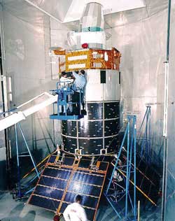
After launch, Air Force Space Command controllers at Schriever Air Force Base in Colorado gradually move the satellite into its geosynchronous operational parking slot over the equator. Within several days of the launch, a team comprised of specialists from the DSP program office here, the Aerospace Corporation, TRW and Aerojet will begin on-orbit checkout of the satellite from the TRW Orbital Test Station in Redondo Beach, Calif. The systems checkout and test can take up to 30 days before the satellite is deemed operational and turned over to Air Force Space Command for use. The 21st Space Wing at Peterson AFB, Colo., operates the DSP satellites and reports warning information to the North American Aerospace Defense Command and U.S. Space Command early warning centers in Cheyenne Mountain (near Colorado Springs). The development and acquisition of the Defense Support Program satellites is managed by the Space Based Infrared System Program Office at the Air Force Space and Missile Systems Center (Air Force Materiel Command) at Los Angeles Air Force Base, Calif. The Lockheed Martin Astronautics Titan launch vehicle, The Boeing Company's Inertial Upper Stage and the TRW and Aerojet built satellite are integrated at Cape Canaveral Air Station Florida by the 45th Space Wing's 3rd Space Launch Squadron. The operation of the DSP satellite is under the control of the Air Force Space Command's 50th Space Wing at Schriever Air Force Base.
|
Flight data file Vehicle: Titan 4B/IUS (B-29) Payload: DSP-20 Launch date: May 8, 2000 Launch window: 1330-1730 GMT (9:30 a.m.-1:30 p.m. EDT) Launch site: SLC-40, Cape Canaveral Air Force Station, Fla. Launch pad tour Explore the scene at Cape Canaveral Air Force Station's Launch Complex 40 through Spaceflight Now's virtual reality camera during final preparations for the launch of the Titan 4 rocket and DSP-20 satellite. VIEW (247k QuickTime file) Download QuickTime 4 software to view this file. Pre-launch briefing Launch preview - Read our story for a complete preview of the Titan 4 launch. Launch timeline - Chart with times and descriptions of events to occur during the launch. Titan 4B vehicle data - Overview of the rocket that will launch DSP-20 into space. |
|||||||
|
MISSION STATUS CENTER |
||||||||