

|
|
|
|
|
|

|
|
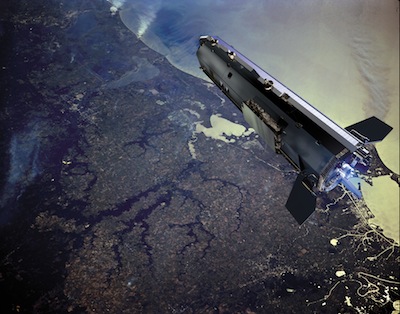
Running on empty, GOCE satellite falls back to Earth BY STEPHEN CLARK SPACEFLIGHT NOW Posted: November 10, 2013 Updated: 0230 GMT A European research satellite plummeted to Earth late Sunday, breaking up from destructive aerodynamic forces as it streaked through the upper atmosphere, likely falling somewhere over Siberia, the western Pacific or Indian Ocean, or Antarctica.
The exact location of the spacecraft's fall from orbit has not been pinpointed. ESA said ground controllers last heard from the $466 million Gravity Field and Steady-State Ocean Explorer, or GOCE, satellite at it passed over the Troll ground station in Antarctica at about 2242 GMT (5:42 p.m. EST). GOCE's pass over the Antarctic ground station was the mission's final planned communications opportunity. ESA's space debris office's final prediction was that GOCE's re-entry would occur between 2250 GMT and 0050 GMT (5:50-7:50 p.m. EST) Sunday. Engineers monitored GOCE's final hours from the European Space Operations Center in Darmstadt, Germany. At the time of the last pass over Antarctica, GOCE was operating normally at an altitude of just 120 kilometers, or 74 miles. "At an altitude of less than 120 km, the spacecraft is - against expectations - still functional," the GOCE operations team said in an update posted on ESA's website. Officials expected GOCE to disintegrate when it reaches an altitude of about 80 kilometers, or 49 miles. Fragments from the 2,209-pound satellite were expected to fall along a ground track more than 500 miles long. Computer models predicted up to one-quarter of GOCE's mass, or about 550 pounds, would survive the re-entry and reach Earth's surface. But space debris experts said the risk to life and property from GOCE's re-entry was staggeringly low. Heiner Klinkrad, head of ESA's space debris office, said a person was 250,000 times more likely to win the jackpot in the German Lotto than be struck by debris from GOCE. No one has ever been injured from re-entering space junk. GOCE launched from Russia in March 2009 into an unusual low-altitude orbit selected to allow precise measurements of Earth's gravity field. The satellite's gradiometer instrument, which consisted of three pairs of identical accelerometers to detect fluctuations in the tug of Earth's gravity, helped scientists probe the structure of the planet's interior and map ocean currents, which drive Earth's climate.
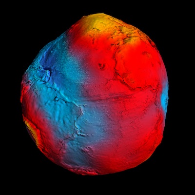
GOCE does not carry a reservoir of conventional chemical rocket fuel. After the satellite's launch, controllers activated GOCE's electrically-powered ion engine to maintain the craft's orbit at at an altitude of 255 kilometers, or 158 miles, for three years. Last year, ESA commanded GOCE to reduce its altitude even further to obtain unrivaled data on the planet's lumpy gravity field. The lower the altitude, the better the science, according to researchers. ESA touts GOCE's results as the best satellite measurements ever made of Earth's gravity field. It mapped the Moho, the boundary between Earth's crust and mantle, with more precision than possible before GOCE. In another first, GOCE's gravity sensor also picked up sound waves generated by the March 2011 Tohuku earthquake off the Japanese coast, which spawned a deadly tsunami that killed more than 15,000 people. Once processed and analyzed, data collected from GOCE's low-altitude orbit could shed light on ocean dynamics, such as eddy currents, according to ESA. A three-dimensional global map produced from GOCE data, called a geoid, shows Earth's surface as influenced only by gravity - without the tug of ocean tides and currents. Geologists use the geoid as a reference for measurements of ocean currents, rising sea levels, and ice movements. Because its low orbit required constant thrusting from the ion engine, GOCE ran out of propellant Oct. 21 and its altitude began to drop due to the effect of atmospheric drag. Although GOCE orbited in a near-vacuum environment, there are enough air molecules at that altitude to impart tiny forces to gradually slow the craft's speed and lower its altitude. As GOCE's altitude dropped lower, the rate of its descent increased until the drag was eventually too much for it to continue in orbit. Follow Stephen Clark on Twitter: @StephenClark1. |
|
|
|
|
||||||||||||||||||||||||||||||||||||||||||||||||||||||||||||||||||||||||||||||||