

|
|
|
|
|
|

|
|
ESA consults imagery to diagnose Envisat anomaly BY STEPHEN CLARK SPACEFLIGHT NOW Posted: April 21, 2012 WASHINGTON -- Engineers are analyzing satellite and ground imagery of the European Space Agency's Envisat environmental spacecraft to determine if the $3.4 billion mission can resume after controllers lost contact with the platform April 8.
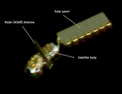
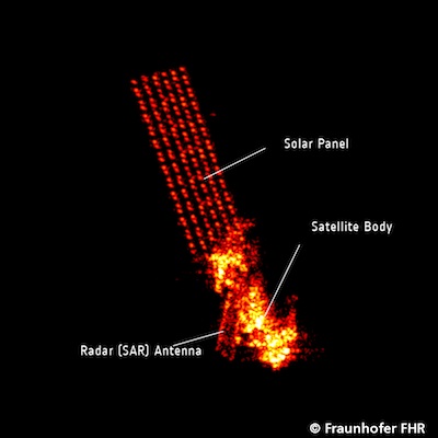
The French space agency, CNES, tasked the Pleiades imaging satellite to snapped photos of Envisat on April 15. The satellites were flying on separate trajectories at about 5 miles per second, but the quick agility of Pleiades, which launched in December, proved sufficient to collect optical imagery of silent Envisat from less than 60 miles away. Officials are also examining radar imagery from the Fraunhofer Institute for High Frequency Physics and Radar Techniques in Wachtberg, Germany. The optical and radar imagery show Envisat's main body, solar panel and radar antenna. Engineers are looking closely at the orientation of Envisat's solar panel to gauge whether it is in position to collect sunlight and generate electricity. If Envisat entered safe mode before its batteries were depleted, there could be a chance to regain control of the satellite. "These unique images will enable us to analyse Envisat's orientation, which will indicate whether we are able to regain contact with the satellite," said Manfred Warhaut, head of ESA's mission operations department. Tracking data from the U.S. military's Joint Space Operations Center show Envisat remains in a stable orbit about 475 miles above Earth. ESA officials say the anomaly could be caused by a power failure in Envisat's data handling system or an electrical glitch elsewhere on the satellite.
The spacecraft bus stretches more than 30 feet long, and its solar array spans 85 feet. The platform is outfitted with 10 instruments to probe the planet's land, oceans, ice and atmosphere.
"Envisat data were used continuously by oil spill services, by sea ice monitoring, by different types of meteorological forecasts, also sea state forecasts, by atmospheric monitoring systems, and also by terrain subsidence monitoring for many cities in Europe and elsewhere," said Volker Liebig, ESA's director of Earth observation programs.
Envisat and its predecessor satellites provided a continuous 20-year archive of research data.
"We monitored constantly the retreat of the Arctic sea ice coverage," Liebig told reporters April 13. "We found with the satellite the mobilization of the glaciers in Greenland and Antarctica. This led to extensive research from satellites and on the ground to understand what causes this mobilization."
Envisat's broad portfolio included measurements of atmospheric chemistry, rising sea levels, plate tectonics, greenhouse gas emissions, and land subsidence.
Europe is building a series of smaller Sentinel satellites to replace portions of Envisat's observation mission.
The Sentinel satellites are developed by ESA on behalf of the European Union's Global Monitoring for Environment and Security, or GMES, program.
The first Sentinel satellite is due to launch in 2013. Each Sentinel will carry instruments to fulfill part of Envisat's mission, including radar observations, high-resolution imaging, ocean surface monitoring, and atmospheric studies.
|
|
|
|
|
||||||||||||||||||||||||||||||||||||||||||||||||||||||||||||||||||||||||||||||||