|
|
|
|
|
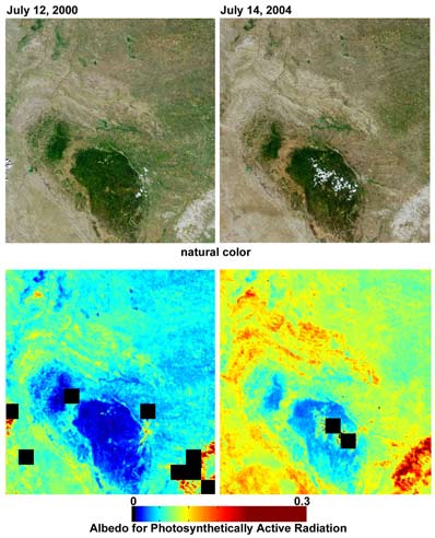
Drought in the Black Hills studied from space NASA/JPL PHOTO RELEASE Posted: May 18, 2005 Despite good rainfall and record-setting snowstorms in the spring of 2005, most of northeastern Wyoming, the Black Hills, and western South Dakota remain in the midst of a severe drought. This set of images and maps from NASA's Multi-angle Imaging SpectroRadiometer (MISR) contrast the appearance of the Black Hills region of northwestern South Dakota on July 12, 2000 (left column), with views acquired four years later, on July 14, 2004 (right column). The natural-color images along the top are from MISR's nadir (downward-looking) camera. The browning that appears in 2004 compared with 2000 indicates that the vigor of green vegetation was significantly diminished in 2004.
Albedo measures the fraction of incident sunlight that is reflected by a surface, and can vary between zero (if all the incident sunlight is absorbed and none is reflected) and one (if all sunlight is reflected and none is absorbed). Dense forest has a low albedo; bright desert, snow and clouds, have a high albedo. Here, albedo is provided for the wavelengths of sunlight that plants use for photosynthesis (400 - 700 nanometers). This measurement is known as the albedo for Photosynthetically Active Radiation (PAR). Surfaces with greater absorption of PAR appear here in blue hues, whereas surfaces with lower absorption appear as green, yellow, orange or red. Black pixels indicate areas where albedo could not be derived, usually due to the presence of clouds. In July 2004, low albedo areas (blue pixels) are notably reduced in extent, and higher albedo areas (yellow, orange and red pixels) have increased. Because incoming sunlight is scattered by tiny particles in the atmosphere, satellite measurements of albedo and other surface properties must correct for the effects of the intervening atmosphere. These albedo retrievals make use of MISR's simultaneously derived aerosol properties to make these corrections. The multiangular nature of MISR data is also used to account for the fact that most surfaces reflect sunlight into all upward directions, with intensities that vary with angle of view. The Multi-angle Imaging SpectroRadiometer observes the daylit Earth continuously and every 9 days views the entire globe between 82 deg north and 82 deg south latitude. This image area covers about 243 kilometers by 259 kilometers. These data products were generated from a portion of the imagery acquired during Terra orbits 3020 and 24325 and utilize data from within blocks 54 to 56 within World Reference System-2 paths 33 and 34. MISR was built and is managed by NASA's Jet Propulsion Laboratory, Pasadena, CA, for NASA's Office of Earth Science, Washington, DC. The Terra satellite is managed by NASA's Goddard Space Flight Center, Greenbelt, MD. JPL is a division of the California Institute of Technology. |
|
|
|
|
|||||||||||||||||||||