
Spaceflight Now +
|
|
|
|
|

Premium video content for our Spaceflight Now Plus subscribers.
Hurricane Ivan
 Cameras on the International Space Station see Hurricane Ivan as the orbiting complex flies over the powerful storm. (3min 05sec file) Cameras on the International Space Station see Hurricane Ivan as the orbiting complex flies over the powerful storm. (3min 05sec file)
 Play video Play video
Friday's Genesis update
 On Friday, Sept. 10, officials hold a news conference from Utah to update reporters on the recovery operations to salvage the Genesis sample return mission. (44min 47sec file) On Friday, Sept. 10, officials hold a news conference from Utah to update reporters on the recovery operations to salvage the Genesis sample return mission. (44min 47sec file)
Play audio
Genesis recovered
 Workers recover the Genesis solar wind samples from the impact crater and take the equipment into a facility for examination. (2min 08sec file) Workers recover the Genesis solar wind samples from the impact crater and take the equipment into a facility for examination. (2min 08sec file)
Play video
Tour of KSC hurricane damage
 Martin Wilson, manager of the Thermal Protection System Facility, gives a tour of the highly damaged building at Kennedy Space Center in the wake of Hurricane Frances. (2min 31sec file) Martin Wilson, manager of the Thermal Protection System Facility, gives a tour of the highly damaged building at Kennedy Space Center in the wake of Hurricane Frances. (2min 31sec file)
Play video
Inside the VAB
 Go inside Kennedy Space Center's hurricane-battered Vehicle Assembly Building and also see the damage to the 52-story tall facility's roof. (2min 51sec file) Go inside Kennedy Space Center's hurricane-battered Vehicle Assembly Building and also see the damage to the 52-story tall facility's roof. (2min 51sec file)
Play video
Post-impact news briefing
 Officials hold a post-landing news conference in Utah a couple hours after Genesis returned to Earth on Sept. 8. (40min 52sec file) Officials hold a post-landing news conference in Utah a couple hours after Genesis returned to Earth on Sept. 8. (40min 52sec file)
Play video
Genesis crash lands
 The Genesis sample return capsule tumbles through the sky and impacts the desert floor in Utah after its speed-slowing chute and parafoil failed to deploy for a mid-air recovery by a helicopter. (2min 29sec file) The Genesis sample return capsule tumbles through the sky and impacts the desert floor in Utah after its speed-slowing chute and parafoil failed to deploy for a mid-air recovery by a helicopter. (2min 29sec file)
Play video
Slow-motion
 This slow-motion video shows the Genesis capsule slamming into the ground. (1min 06sec file) This slow-motion video shows the Genesis capsule slamming into the ground. (1min 06sec file)
Play video
Tuesday's hurricane news briefing
 The Kennedy Space Center director and 45th Space Wing commander from Cape Canaveral Air Force Station hold a news conference Tuesday to describe damage from Hurricane Frances. (46min 15sec file) The Kennedy Space Center director and 45th Space Wing commander from Cape Canaveral Air Force Station hold a news conference Tuesday to describe damage from Hurricane Frances. (46min 15sec file)
Play audio
Footage of KSC damage
 This movie takes you on a tour of hurricane damage to Kennedy Space Center's Vehicle Assembly Building, shuttle tile manufacturing facility and press site. (3min 11sec file) This movie takes you on a tour of hurricane damage to Kennedy Space Center's Vehicle Assembly Building, shuttle tile manufacturing facility and press site. (3min 11sec file)
Play video
Become a subscriber
More video
|
|
|
|
|
|
Frances, Ivan contribute to hurricane studies
NASA/JPL NEWS RELEASE
Posted: September 14, 2004
Seen through the eyes of the Multi-angle Imaging SpectroRadiometer aboard NASA's Terra satellite, the menacing clouds of Hurricanes Frances and Ivan provide a wealth of information that can help improve hurricane forecasts.
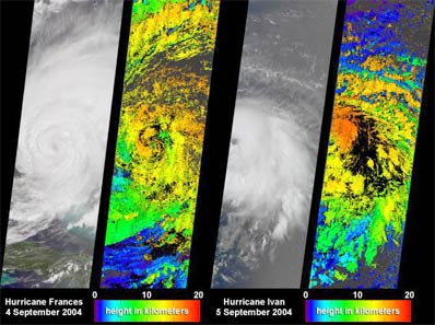
Credit: NASA/GSFC/LaRC/JPL, MISR Team
Download larger image version here
|
The ability of forecasters to predict the intensity and amount of rainfall associated with hurricanes still requires improvement, particularly on the 24- to 48-hour timescales vital for disaster planning. Scientists need to better understand the complex interactions that lead to hurricane intensification and dissipation, and the various physical processes that affect hurricane intensity and rainfall distributions. Because uncertainties in representing hurricane cloud processes still exist, it is vital that model findings be evaluated against actual hurricane observations whenever possible. Two-dimensional maps of cloud heights such as those provided by the Multi-angle Imaging SpectroRadiometer offer an unprecedented opportunity for comparing simulated cloud fields against actual hurricane observations.
The newly released images of Hurricanes Frances and Ivan were acquired Sept. 4 and Sept. 5, 2004, respectively, when Frances' eye sat just off the coast of eastern Florida and Ivan was heading toward the central and western Caribbean.
The left-hand panel in each image pair is a natural-color view from the instrument's nadir camera. The right-hand panels are computer-generated cloud-top height retrievals produced by comparing the features of images acquired at different view angles. When these images were acquired, clouds within Frances and Ivan had attained altitudes of 15 and 16 kilometers (9.3 and 9.9 miles) above sea level, respectively.
The instrument is one of several Earth-observing experiments aboard Terra, launched in December 1999. The instrument acquires images of Earth at nine angles simultaneously, using nine separate cameras pointed forward, downward and backward along its flight path. It observes the daylit Earth continuously and every 9 days views the entire globe between 82 degrees north and 82 degrees south latitude. It was built and is managed by NASA's Jet Propulsion Laboratory, Pasadena, Calif. JPL is a division of the California Institute of Technology in Pasadena.
|
|
|
|
|

