|
 |
|
||||
|
|
||||
|
NASA cites progress in earthquake research NASA NEWS RELEASE Posted: December 4, 2003 Nearly 10 years after Los Angeles was shaken by the devastating, magnitude 6.7 Northridge earthquake, scientists at NASA and other institutions say maturing space-based technologies, new ground-based techniques and more complex computer models are rapidly advancing our understanding of earthquakes and earthquake processes.
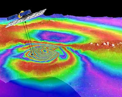
Two months before the Northridge earthquake, Donnellan and university colleagues published a paper in the journal Nature on ground deformation north of Los Angeles' San Fernando Valley. Six years of Global Positioning System (GPS) data showed the area's faults were active and building up strain, and indicated the size and style of a potential earthquake there. Following the earthquake, the data made it possible to rapidly determine where the fault ruptured and to measure how the earthquake had deformed the Earth's surface. Space-based instruments can image Earth movements to within fractions of an inch, measuring the slow buildup of deformation along faults, and mapping ground deformation after an earthquake. Two primary tools are the space-based GPS navigation system and Interferometric Synthetic Aperture Radar (InSAR). The latter compares satellite radar images of Earth taken at different times to detect ground movement. InSAR complements surface measurements because it lets us look at whole regions in a spatial context. An InSAR mission is also a key component of EarthScope, a jointly led initiative by the National Science Foundation (NSF), NASA and the U.S. Geological Survey (USGS). EarthScope studies the North American continent's structure and evolution, and the physical processes that control earthquakes and volcanic eruptions, according to Dr. James Whitcomb, section head for Special Projects, Earth Sciences Division, National Science Foundation, Arlington, Va. Precise Earth surface-movement data measure strain, and provide a first approximation of where earthquakes are likely to occur, notes Dr. Brad Hager, a Massachusetts Institute of Technology (MIT) professor and co-author of the 1993 Nature paper. "In California, patterns of ground deformation are complicated by the complex interactions between fault systems," he says. "Interpreting this data requires computer models that can estimate how much deformation has accumulated and identify regions where strain should be released, but hasn't been."
NASA's QuakeSim project is developing a similar forecasting methodology. Its tools simulate earthquake processes, and manage and model the increasing quantities of data available. "We're focusing on observing and understanding earthquakes in space and time, and developing methods that use patterns of small earthquakes to forecast larger ones," Rundle explains. "New simulations of earthquakes on California's active faults are providing considerable insight, showing earthquakes tend to "cluster" in space and time due to their interactions: that is, an earthquake on one fault section can turn on or off earthquake activity on nearby fault sections, depending on the relative orientation of the faults. Simulations have led researchers to conclude that fault system geometry determines earthquake activity patterns." A NASA/Department of Energy-funded research team reports promising results from an experiment to forecast earthquakes in southern/central California from 2000 to 2010. It uses mathematical methods to forecast likely locations of earthquakes above magnitude 5 by processing data on earthquakes of about magnitude 3 from the past decade. The high-risk regions identified in the forecast are refined from those already identified by the government as susceptible to large earthquakes. Five earthquakes greater than magnitude 5 have occurred since the research was completed, all in those high-risk regions. Dr. Wayne Thatcher, a senior research geophysicist at the USGS, Menlo Park, Calif., says as these technologies are validated they will be transferred to end users. "Such data and models improve understanding of earthquake and volcanic processes, substantially refining seismic hazard maps and resulting in more appropriate, earthquake-resistant construction codes and more targeted retrofitting strategies," he says.
|
|
|||||