|
 |
|
||||
|
|
||||
|
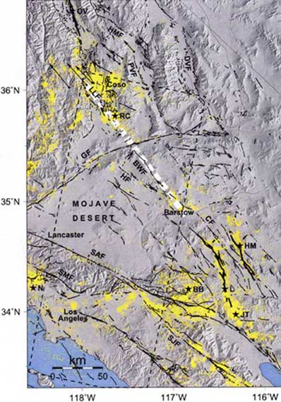
Earthquake studies: Fault moving faster than believed NASA/JPL NEWS RELEASE Posted: November 5, 2001 Scientists at NASA's Jet Propulsion Laboratory, Pasadena, Calif., and the University of California, Los Angeles, have concluded that earthquake fault zones in California's eastern Mojave Desert are moving in different ways than they expected.
New findings indicate that more than half of the right- lateral motion of the Eastern California shear zone is sharply concentrated along the Blackwater Little Lake fault system. The rapid strain accumulation observed along the fault system indicates that the fault is building up stress in the shallow crust at a rate three times faster than the rate inferred from geological observations. This may be the manifestation of stress transfer between the Garlock fault and other faults in the Mojave area, in particular those that produced the magnitude 7.3 Landers earthquake in 1992 and the magnitude 7.8 Owens Valley earthquake in 1872. Scientists arrived at the conclusion after studying radar interferometry data collected by satellites over the last eight years. Radar interferometry is a method to map the topography and displacement of the Earth's surface with extreme accuracy. A paper with the findings is in the Nov. 1, 2001, issue of the journal Geology. "The most exciting thing is we discovered something we didn't expect. We were looking for deformation on the Garlock fault, but we saw in the image a concentration of shear along the Blackwater Little Lake fault, which cuts the Garlock fault at a right angle," said Dr. Gilles Peltzer, a UCLA professor and JPL research scientist who is the lead author of the study. "Radar interferometry has been applied previously to the study of earthquakes, and what we are imaging here is the surface strain field produced by the slow creep occurring at depth on active faults between earthquakes." Operated by the European Space Agency, the European Remote Sensing satellites use interaction of radar waves to measure distances and angles precisely. The satellites look at Earth in a slanted angle at 23 degrees. The only other way to gain such accurate information on fault displacement would be to place Global Positioning System receivers every 50 meters (about 165 feet). JPL is a division of the California Institute of
Technology in Pasadena.
|
|
||||