|
 |
|
||||
|
|
||||
|
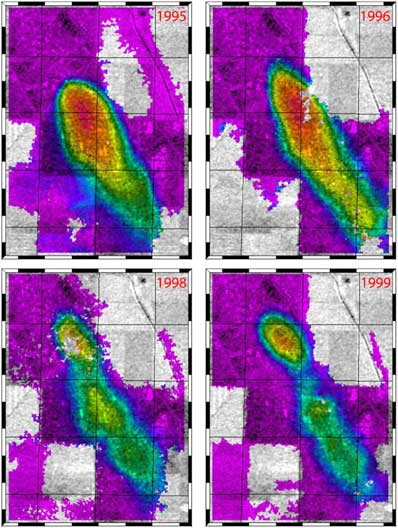
NASA helps project to use radar for monitoring oil fields NASA/JPL NEWS RELEASE Posted: October 20, 2001 Radar images of the surface of an oil field are helping scientists understand how rocks deep within the field behave, which may help oil companies reduce costs and increase production. In this pilot study, the researchers are monitoring where and how much the ground surface sinks as oil is pumped from a large oil field.
The researchers compared radar images of the oil field taken during 1995, 1996, 1998 and 1999, using a technique called radar interferometry. This involves precisely aligning two radar images taken at different times. It produces accurate measurements of topography and of surfaces that may have changed in the time between collection of the data. Using these radar data, scientists found that parts of the oil field were subsiding unusually rapidly, more than 3 centimeters (1.2 inches) a month, in 1995 and 1996. They also discovered that while the ground subsidence rate decreased in the center part of the oilfield, it increased in the northern part in every year observed between 1995 and 1999. "This is an exciting new application for synthetic aperture radar, monitoring subsidence over an oil field from space," said Fielding. "We're now working with Chevron to combine these subsidence maps with the records of oil and water extraction and injection to understand how oil-containing rock is behaving beneath the surface." The project is a collaboration supported by NASA, the University of California, Berkeley, the Department of Energy and Chevron U.S.A. The results were presented in October 2001 at the Society of Petroleum Engineers Annual Technical Conference and Exhibition. JPL is a division of the California Institute of Technology in Pasadena.
|
|
||||