|
 |
|
||||
|
|
||||
|
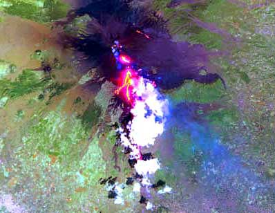
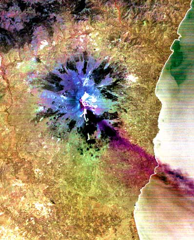
More satellites views released of Mt. Etna eruption NASA/JPL PHOTO RELEASE Posted: August 5, 2001 Mount Etna, Europe's most active volcano, continues to spill rivers of lava following a July 17 eruption. The recent activity of the 3,315-meter (10,876-foot) high volcano can be seen in two images taken Sunday, July 29 by the Advanced Spaceborne Thermal Emission and Reflection Radiometer on NASA's Terra spacecraft. One image shows the lava advancing toward the town of Nicolosi on the Italian island of Sicily. While the last two days have been relatively calm, a river of lava is about 4 kilometers (2.5 miles) away from the town. Thick ash clouds caused airport closures and forced residents in the nearby city of Catania to use umbrellas while walking outside. The other image shows a large sulfur dioxide plume coming from the summit of the volcano.
The Advanced Spaceborne Thermal Emission and Reflection Radiometer is one of five Earth-observing instruments launched Dec. 18, 1999, on NASA's Terra satellite. The instrument was built by Japan's Ministry of International Trade and Industry. A joint U.S./Japan science team is responsible for validation and calibration of the instrument and the data products. The primary goal of the mission is to obtain high-resolution image data in 14 channels over the entire land surface, as well as black and white stereo images. With revisit time of between 4 and 16 days, the radiometer will provide the capability for repeat coverage of changing areas on Earth's surface. The broad spectral coverage and high spectral resolution of the radiometer will provide scientists in numerous disciplines with critical information for surface mapping and monitoring dynamic conditions and temporal change.
|
|
|||||