|
|
||
|
|
||
|
NASA's Terra satellite confirms a less snowy winter NASA-GSFC NEWS RELEASE Posted: July 29, 2000
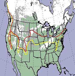
Dr. Dorothy K. Hall will present results from MODIS at the International Geoscience and Remote Sensing Symposium (IGARSS) today in Hawaii. "The winter of 1999-2000 brought relatively little snow cover to parts of the North American continent, and the snow melted early as compared to normal years. Low snow cover can result in drier soil conditions, affect crop production, and lead to wildfires," Hall noted. Using data from MODIS and other satellites, scientists can determine the extent of spring snowcover which can be a harbinger of flood or drought conditions. The MODIS composite snowcover map, derived from data taken over an 8-day period between March 5 and 12, depicts the snow line into Canada, in the provinces of Saskatchewan and Manitoba. Only scattered snowcover existed over parts of the northern United States, though the mountains were still snow covered. According to the National Oceanic and Atmospheric Administration's National Environmental Satellite, Data, and Information Service (NOAA/NESDIS) the average March snow line would normally extend from New England through the Midwest including southern Wisconsin, to southern portions of North Dakota. The snow line then normally continues farther south in the western states including the Rocky Mountains and west into the Cascades and the Sierras. NOAA/NESDIS has been producing weekly snow maps of the Northern Hemisphere land surfaces since 1966 using visible-band satellite imagery. Because snow has such a high reflectivity compared to other surfaces on Earth, snow covered areas appear much brighter in satellite imagery than most other surface types. However, Dr. Hall noted that the key difference between the MODIS-produced snow maps and the images produced by NOAA/NESDIS is that "MODIS has a higher resolution and an improved ability to discriminate between snow and clouds."
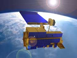
Many areas of the world rely on the snowmelt for irrigation and drinking water. In the western U.S, mountain snowpack contributes up to 75 percent of all year-round surface water supplies. Therefore, it is necessary to monitor snowpacks closely throughout the winter and spring for assessment of water supply and flooding potential, and MODIS data will prove useful in this capacity. Dr. Hall said that the lesser snowpack in March hinted at possible drought conditions from the Midwest to the Rockies this summer. However, recent rains have alleviated dry conditions in the Midwest. As an instrument on NASA's Terra satellite, MODIS continuously observes the Earth's surface in a sweeping motion, every 1-2 days with a scanning imaging radiometer. Its wide field of view (over 2,300 kilometers or over 1,429 miles) provides images of daylight-reflected solar radiation and daytime and nighttime thermal emissions over the entire globe. Terra was launched on December 18, 1999 and began collecting data on February 24, 2000, part of a 15-year global data set on which to base scientific investigations about the Earth. Snow and ice products generated from MODIS data will include daily and 8-day composite snow-cover maps, including lake ice on large inland lakes, daily and 8-day composite sea ice-cover maps, and sea ice-surface temperature maps will be produced. There will also be 8-day composite map products available at a high resolution for climate modeling. These products will be archived at the National Snow and Ice Data Center (NSIDC) in Boulder, Colorado.
|
|
|||||||