|
|
||
|
|
||
|
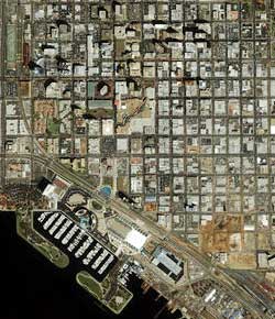
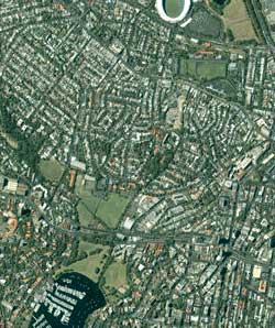
Ikonos imaging satellite helps real estate developers SPACE IMAGING NEWS RELEASE Posted: June 28, 2000
"Ikonos color imagery of the Earth gives our real estate customers access to a brand-new visual information source for conducting business," said Brian Soliday, vice president of Space Imaging North American sales and marketing. "This imagery provides significantly more detail and information about the land and the communities which the real estate industry is working to develop and manage. Compared to traditional line maps, this imagery provides up-to-date, content-rich information about our ever-changing landscape." The highly detailed digital images show features such as trees, lawns, houses, schools, roads, rivers and parks. Images can be overlain with geographic data such as street names, zip codes, zoning data, park names and other information to help developers determine which areas are suitable for development, evaluate existing infrastructure and determine property values. Real estate customers can use the digital images for:
"Our unique technology allows us to convert high-resolution Ikonos satellite images into 3D environments that can be explored over the Internet via the free TerraExplorer viewer (available from Space Imaging under the CARTERRA3D brand)," said Shimon Sharon, president and chief executive officer of Skyline Software Systems, Inc.
Ikonos image products are sold under the CARTERRA brand name. Prices range from $30-$45/sq.mi ($12-$17/sq.km) for North America (with a minimum order of $1000) or $75-$112/sq.mi ($29-$44/sq.km) for regions outside of North America (with a minimum order of $2000). CARTERRA products are immediately available and can be ordered through Space Imaging's Customer Service Center at 301-552-0537 or 800-232-9037.
|
|
|||||||