|
|
||
|
|
||
|
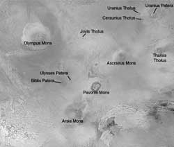
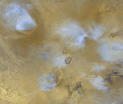
Satellite shoots regional view of Martian Tharsis volcanoes NASA/JPL/MSSS PHOTO RELEASE Posted: June 12, 2000
The grayscale image on the (above right) shows the name of each volcano in the scene. The white or bluish-white features are clouds. Clouds are common over the larger Tharsis volcanoes in mid-afternoon.
Pavonis Mons lies on the martian equator, north is up, and sunlight is illuminating the scene from the left. The picture is a mosaic of red and blue filter images taken on three consecutive orbits. The slightly blurred appearance of the left side of Arsia Mons results from distortion toward the edges of the images used to make the mosaic. To remove the blurr, an image obtained on another day would be added to the mosaic--however, this image would not match well because the cloud patterns will have changed by the next day. Mosaics such as the one shown here are used to monitor changes in martian weather and to plan future observations. Malin Space Science Systems and the California Institute of Technology built the MOC using spare hardware from the Mars Observer mission. MSSS operates the camera from its facilities in San Diego, CA. The Jet Propulsion Laboratory's Mars Surveyor Operations Project operates the Mars Global Surveyor spacecraft with its industrial partner, Lockheed Martin Astronautics, from facilities in Pasadena, CA and Denver, CO.
|
|
||||||