|
|
||
|
|
||
|
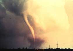
NASA trying to predict killer tornadoes from space NASA SCIENCE RELEASE Posted: May 3, 2000
During the afternoon and evening of May 3, 1999, a series of "supercell" thunderstorms produced large, destructive tornadoes concentrated in central Oklahoma. There were more than 70 tornadoes in Oklahoma, Kansas and Texas with hail as large as 4.5 inches in diameter. The tornadoes killed more than 40 people and caused more than $1 billion in damage. Scientists hope to gain knowledge from these natural disasters that they can apply in future situations. During the May 3 tornado outbreak the NASA Tropical Rainfall Measuring Mission (TRMM, pronounced "trim") satellite made an overpass of 6 rotating supercell storms around 11pm. Dr. Steve Goodman of the Global Hydrology and Climate Center (GHCC) and his colleagues at the GHCC and the National Severe Storms Laboratory will present the details of the satellite and additional ground-based observations in a paper at the 20th Conference on Severe Local Storms in Orlando in September. Supercells are the largest, strongest, and longest lasting thunderstorms; they often generate tornadoes. Supercells derive their destructive power from mesocyclones - rotating winds rising into the storm. TRMM instruments spotted six supercells in Oklahoma. One of the supercells over Stroud, Oklahoma produced phenomenal effects. Lightning rates exceeded 90 flashes per minute. This "outrageous number," says Goodman, is one of the highest observed worldwide to date by the Lightning Imaging Sensor (LIS) on TRMM. For comparison, a typical thunderstorm might produce just a few flashes per minute. During severe storms in Florida, the lightning capitol of the United States, LIS has observed up to 60 flashes per minute. "The thing that's unique about these severe storms," says Goodman, "is that most of the lightning is in-cloud, not cloud-to-ground. A typical storm may have a 4:1 ratio of in-cloud to cloud-to-ground lightning. The ratio for one of the Stroud supercells was 45:1! There were 90 in-cloud flashes recorded in one minute compared to only 2 cloud-to-ground flashes." "Tornado-producing supercells are marked by extreme lightning flash rates, but just before a tornado forms we actually see a rapid decrease in the lightning counts," continued Goodman. "This is caused by downdrafts that spawn the tornadoes. To actually predict tornado formation based on this precursor, we need a good time series of lightning counts. TRMM doesn't provide that because we just get a 90 second snapshot of the lightning activity as the satellite zips by the storm system."
This research is "not just for science," says Goodman. Over the past century in North America, tornado warnings have dramatically decreased the fatality rate from these storms. With 75 percent of the world's reported tornadoes occurring in the U.S., the need for timely predictions is clear. The ability to recognize which storms will become tornadoes can increase the lead time and decrease the false alarm rate of storm warnings. Timely and accurate storm readings will help emergency service operations and forecasters. Accuracy is imperative, says Goodman, because "people react much differently to tornado warnings than [they do] to severe storm warnings." Certain precautions should be taken as the storm is elevated to tornado status to protect lives and property. Conversely, unnecessary warnings can foster indifference, a problem Goodman calls the "cry wolf syndrome." While the most favorable conditions for tornadoes are found in the Great Plains, severe weather knocks at the Southeast's door each spring as well. Space-based lightning measurements will be even more useful there where old-fashioned spotter networks still provide tornado warnings, many times for nocturnal storms that are hard to see due to the region's hilly topography and high humidity. "[We] envision a day of more accurate detection of severe weather," concludes Goodman. "With data from space we hope to reduce the rate of false alarms and increase the lead time for tornado prediction by 50%. Improvements like these can really save lives." The Global Hydrology and Climate Center is a joint venture between government and academia to study the global water cycle and its effect on Earth's climate. Jointly funded by NASA and its academic partners, and jointly operated by NASA's Marshall Space Flight Center in Huntsville, Ala., and the University of Alabama in Huntsville, the Center conducts research in a number of critical areas.
|
NewsAlert Sign up for Astronomy Now's NewsAlert service and have the latest news in astronomy and space e-mailed directly to your desktop (free of charge). |
|||||||