|
|
||
|
|
||
|
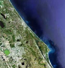
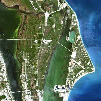
NASA's Landsat 7 celebrates its first birthday in space NASA NEWS RELEASE Posted: April 21, 2000
"The resolution and absolute calibration of the imagery collected by the Landsat 7 'Enhanced Thematic Mapper Plus' instrument are better than what has been provided by previous Landsat sensors," said Dr. Darrel Williams, Landsat 7 Project Scientist, at NASA's Goddard Space Flight Center, Greenbelt, MD. "These enhancements permit users to more easily register the image data to maps, to resolve smaller features in the imagery and to more confidently compare current results with those derived from analyses of data acquired by earlier Landsat sensors." Landsat 7 is the latest in a continuous series of Earth observation satellites that began with Landsat 1 in 1972. Unlike its predecessors, Landsat 7 can create global maps of the Earth in record time due to technology advances developed by NASA.
Farmers and commodity brokers have used the data to assess and predict crop yields locally, regionally and on a global basis. A group of scientists, led by Dr. Susan Moran of the U.S. Department of Agriculture, is using Landsat 7 data help farmers and land managers increase crop yields and cut costs while reducing environmental pollution. Scientists from NASA's partner agency in the Landsat 7 mission, the U.S. Geological Survey (USGS), are using Landsat 7 to determine the amount and condition of dry biomass on the ground, a potential fuel source for wildfires that can threaten humans, animals and natural resources. In addition, USGS scientists have used Landsat 7 to provide a synoptic view of the landscape simultaneously with the outbreak of infectious diseases -- most recently in the outbreak of the West Nile Virus, a mosquito-borne disease that caused encephalitis in some residents of New York City last summer. "Landsat 7 is already proving to be a major source for information about the land mass of the planet, and building on previous satellite data provides us a long-term record of information about the Earth," said USGS Landsat program manager, R. J. Thompson.
The spacecraft is controlled from a mission operations center at Goddard. NASA controllers will continue to operate the spacecraft until Oct. 1, 2000, when control will be turned over to the U.S. Geological Survey. The U.S. Geological Survey currently provides Landsat 7 image products to hundreds of customers each week through an Internet site that allows visitors to preview imagery before purchase. Landsat 7 is part of NASA's Earth Science Enterprise, a long-term global research program studying human-induced and natural changes in the Earth's global environment.
|
NewsAlert Sign up for Astronomy Now's NewsAlert service and have the latest news in astronomy and space e-mailed directly to your desktop (free of charge). |
|||||||