|
|
||
|
|
||
|
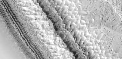
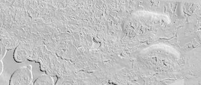
Global Surveyor reveals exotic Martian landscape NASA/JPL/MSSS NEWS RELEASE Posted: April 11, 2000 Two new photo mosaics, created with images from NASA's Mars Global Surveyor spacecraft now in orbit at Mars, may help scientists understand what materials make up the exotic, multi-layers of the South Pole.
These images were acquired by the Mars Orbiter Camera aboard the Mars Global Surveyor spacecraft during the southern spring season in October 1999. Each of these two pictures is a mosaic of many individual MOC images acquired at about 12 m/pixel scale that completely cover the highest latitude (87 degrees S) visible to MOC on each orbital pass over the polar region. Both mosaics cover areas of about 10 x 4 kilometers (6.2 x 2.5 miles) near 87 degrees S, 10 degrees W in the central region of the permanent -- or residual -- south polar cap. They show features at the scale of a small house. Sunlight illuminates each scene from the left. The mosaics were produced by imaging team scientists at the U.S. Geological Survey, Flagstaff, AZ and the California Institute of Technology, Pasadena, CA. Malin Space Science Systems and the California Institute of Technology built the MOC using spare hardware from the Mars Observer mission. MSSS operates the camera from its facilities in San Diego, CA. The Jet Propulsion Laboratory's Mars Surveyor Operations Project operates the Mars Global Surveyor spacecraft with its industrial partner, Lockheed Martin Astronautics, from facilities in Pasadena, CA and Denver, CO. Mars Global Surveyor is managed by the Jet Propulsion Laboratory for NASA's Office of Space Science, Washington, DC. JPL is a division of the California Institute of Technology in Pasadena.
|
NewsAlert Sign up for Astronomy Now's NewsAlert service and have the latest news in astronomy and space e-mailed directly to your desktop (free of charge). |
||||