|
|
||
|
|
||
|
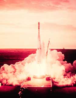
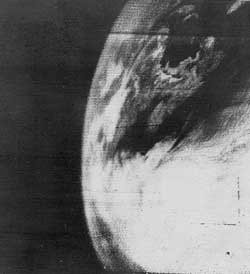
Forty years after the first weather satellite saw Earth NASA/GODDARD NEWS RELEASE Posted: March 31, 2000
The world's first weather satellite, a polar-orbiting satellite, was launched from Cape Canaveral on April 1, 1960. Named "TIROS" for Television Infrared Observation Satellite, it demonstrated the advantage of mapping the earth's cloud cover from satellite altitudes. TIROS showed clouds banded and clustered in unexpected ways. Sightings from the surface had not prepared meteorologists for the interpretation of the cloud patterns that the view from an orbiting satellite would show. Today, the nation's environmental satellites are operated by NOAA's National Environmental Satellite, Data, and Information Service in Suitland, Md. NOAA's environmental satellite system is composed of two types of satellites: geostationary operational environmental satellites for national, regional, short-range warning and "now-casting;" and polar-orbiting environmental satellites for global, long-term forecasting and environmental monitoring. Both GOES and POES are necessary for providing a complete global weather monitoring system. Both also carry search and rescue instruments to relay signals from aviators and mariners in distress.
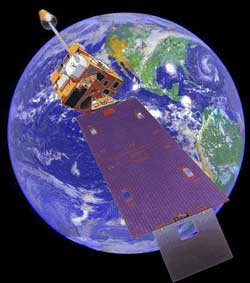
GOES satellites are a mainstay of weather forecasting in the United States. They are the backbone of short-term forecasting or nowcasting. The real-time weather data gathered by GOES satellites, combined with data from Doppler radars and automated surface observing systems, greatly aids weather forecasters in providing warnings of thunderstorms, winter storms, flash floods, hurricanes, and other severe weather. These warnings help to save lives and preserve property. The United States operates two meteorological satellites in geostationary orbit, one over the East Coast and one over the West Coast with overlapping coverage over the United States. Currently, GOES-8 and GOES-10 are in operation. In addition, NOAA operates satellites in the Defense Meteorological Satellite Program (DMSP), which are also polar-orbiting satellites. NOAA also manages the processing and distribution of the millions of bits of data and images the GOES and POES satellites produce each day.
NASA's Goddard Space Flight Center, Greenbelt, Md., is responsible for the procurement, development, launch services and verification testing of the spacecraft, instruments and unique ground equipment. Following deployment of the spacecraft from the launch vehicle, Goddard is responsible for the mission operation phase leading to injection of the satellite into orbit and initial in-orbit satellite checkout and evaluation. On May 5, 1994, President Clinton made the landmark decision to merge the nation's military and civil polar-orbiting operational meteorological satellite systems into a single, national system capable of satisfying both civil and national security requirements for space-based remotely sensed environmental data. The new system is called the National Polar-orbiting Operational Environmental Satellite System, or NPOESS. Convergence of the civil and military programs is the most significant change in U.S. operational remote sensing since the launch of the first weather satellite. The first converged satellite is expected to be available for launch in the latter half of the decade, approximately 2008, depending on when the remaining POES and DMSP program satellite assets are exhausted.
|
NewsAlert Sign up for Astronomy Now's NewsAlert service and have the latest news in astronomy and space e-mailed directly to your desktop (free of charge). |
|||||||||