|
|
||
|
|
||
|
Pacific island safety concern delays U.S. rocket launch BY JUSTIN RAY SPACEFLIGHT NOW Posted: Feb. 27, 2000
Liftoff from Vandenberg Air Force Base in California of the Orbital Sciences-built Taurus rocket was planned for 0923 GMT (4:23 a.m. EST) on Monday. The Air Force, which is running this launch, says the mission won't occur before March 4. The four-stage rocket is loaded with an experimental satellite designed to test new technologies that, if they work, could be used by future spy satellites to detect manufacturing plants where weapons of mass destruction are produced. The island causing the stir is located inside an area where the rocket's spent third stage is predicated to impact during the launch. Officials indicate there is a 95 percent chance the stage will fall within the danger zone, said Lt. Colleen Lehne, spokeswoman for the Air Force's Space and Missile Systems Center. Before all U.S. rocket launches occur, the government checks to ensure the rocket's flight path and planned impact areas are cleared to prevent safety hazards. A launch safety clearance was granted for this upcoming Taurus flight because Air Force maps indicated the island was uninhabited. However, Tahitian authorities informed the U.S. government on Friday that the island is now populated, prompting the launch clearance already issued to be revoked, the Air Force said. U.S. officials were spending the weekend reviewing the rocket's predicated trajectory and the impact zone to ensure accuracy. But engineers were confident their predications were correct, placing the unnamed island within the danger zone. "We run several mathematical models to compute the trajectory and impact areas and they are checking that again," Lehne said.
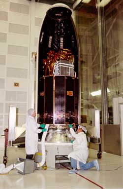
Meanwhile, the problem has been handed from rocket scientists to diplomats in Washington, D.C., to negotiate. "It is all in the hands of the State Dept. now," Lehne said. The confusion was started by Air Force maps that show the island as uninhabited. The State Dept. will try to clear up that question with Tahitian officials. If people are living on the island, the U.S. government might ask Tahiti to move the residents to safety during the launch. The Air Force says if the rocket's trajectory has to be changed to avoid the island altogether, the launch will be delayed at least one month while the Taurus is disassembled on its pad and flight computer reprogrammed. This unusual problem only affects the upcoming Taurus launch and not other rocket flights from Vandenberg. "It is this particular trajectory and particular launch," Lehne said. The West Coast launch site located along central California's Pacific coastline has served 1,790 launches since December 1958. When it does fly, the Taurus rocket will carry into space the Multispectral Thermal Imager satellite for the U.S. Dept. of Energy's Office of Nonproliferation and National Security. Circling about 360 miles above Earth in near-polar orbit, MTI will act as an R&D testbed for futuristic multispectral and thermal imaging. Scientists say the satellite will attempt to prove the imaging techniques in space for the first time by detecting reflected and thermally radiated electromagnetic waves not visible to the human eye.
MTI features a cryogenically-cooled telescope that will observe selected ground sites where researchers know the true conditions. The images will be relayed to MTI's primary communications station in Albuquerque, New Mexico, for comparison to determine the effectiveness of the satellite's technologies. Besides military operations and treaty monitoring, the technology also could be used for environmental and climate research. A secondary experiment aimed at space weather research also will be tested on MTI. Sponsored by the U.S. National Oceanic and Atmospheric Administration and the Czech Republic's Astronomical Institute of the Academy of Sciences, the High-energy X-ray Spectrometer will study solar flares that can damage satellites and threaten astronauts.
Led by Sandia National Laboratories, the MTI project also involves Los Alamos National Laboratory, Savannah River Technology Center, the Air Force Research Laboratory, the National Institute of Standards and Technology, Ball Aerospace, Raytheon and TRW.
|
NewsAlert Sign up for Astronomy Now's NewsAlert service and have the latest news in astronomy and space e-mailed directly to your desktop (free of charge). |
|||||||||