|
 |
|
||||
|
|
||||
|
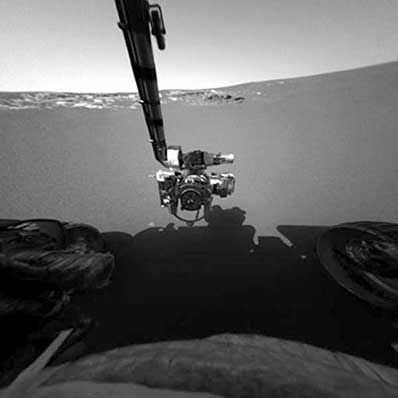
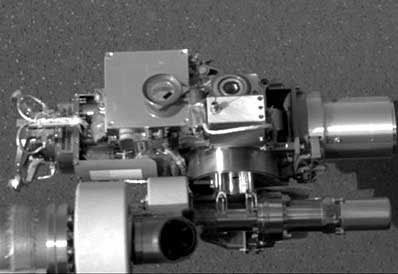
Rover's science arm reaches for clues about Mars' history BY JUSTIN RAY SPACEFLIGHT NOW Posted: February 2, 2004 Lending a hand to unlock the geologic riddles of Mars, the rover Opportunity has extended its instrument-laden arm to begin probing soil on the floor of a small crater where the craft landed. The arm, known as the Instrument Deployment Device, carries the Mossbauer Spectrometer, Alpha Particle X-Ray Spectrometer, Microscopic Imager and Rock Abrasion Tool. "Today's activities were all about the Instrument Deployment Device and the final checks of the in-situ payload," Joe Melko, mechanical system engineer for the robot arm, reported Monday.
"This was a great confirmation to the team that they had done an extraordinary job. The arm is probably the most complex mechanism on the rover," Melko said. "These people were given a tremendously difficult task of fitting the arm in a very tight space with a very small mass budget. They came through with shining colors. We are two for two." Also Monday, scientists unveiled the first full 360-degree color panorama showing the 72-foot diameter crater on the equatorial plains of Meridiani where Opportunity sits. You can download a medium or large version. "This wonderful 360 panorama is in stereo and provides us with a real sense of 'you are there' at the site, gives us a feeling for this bowl-shaped depression that we are now in," said Jeff Johnson, science team member from the U.S. Geological Survey in Flagstaff.
"We ran all the motors in free space, and it performed beautifully," Melko said. Then the Microscopic Imager's cover was opened. "With the opening of the cover, that means we've covered all the motors on Opportunity and Spirit, and they are all working great," Melko said. The Alpha Particle X-Ray Spectrometer and Mossbauer Spectrometer both had their moment in front of Opportunity's camera to complete the inspection for engineers. The Microscopic Imager then took its place on a patch of soil to begin observations. The device promises to reveal features as thin as a human hair. On Tuesday, further work with the Microscopic Imager is planned before switching to the Mossbauer instrument to look for iron-bearing minerals in the soil for nearly 24 hours, Melko said. Wednesday will see the Alpha Particle X-Ray Spectrometer get its turn to make measurements of the chemical elements in the soil over the course of a day, he reported.
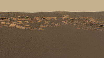
"The science team started thinking seriously about how to attack the outcrop, so to speak, because it is the first outcrop we've ever been to and we need to map it completely with all of the tools that we have," Johnson said. "There is a bit of debate in the team right now as to the best method to do that. It is a bit of traveling salesman problem. How do you do the best science the most quickly with the most efficient end? "One idea right now is we go over to the end of the outcrop that is right in front of us and just start driving towards the edge of it, sort of saddling up to it and taking a lot of very high-resolution pictures at increments until we (reach) the end of the outcrop. We'll have a wonderful, amazing data set that maps this outcrop completely," Johnson said. Driving along side the exposed tabular bedrock features will allow the panoramic camera and the Mini-Thermal Emission Spectrometer to do detailed surveys. But Johnson said engineers and scientists must first determine how close the rover needs to get while also leaving ample room to ensure the solar panels don't bump the rocks.
"From what I've seen there seems to be a prevailing wind direction. I have a feeling that has a lot to do with why just a portion of the crater rim is an outcrop. It may be the outcrop goes all the way around the crater rim and it's just covered up on other sides," Johnson said. "So one of the things we probably will be doing is trying to investigate that, perhaps by trenching with the wheels at some point to see not only what we can tell about the surface/subsurface soils in the crater itself but perhaps we can actually hit some of that bedrock if it's only half-a-wheel depth or so below the surface." Of course, all of the science planning is subject to change. "The wonderful thing about this mission is every day we are getting new data down that can change out perception about the area we are in and how we want to go through the procedure of investigating and exploring," Johnson said.
|
Status quicklook Check the status center for complete coverage. |
|||||||
|
MISSION STATUS CENTER |
||||||||