|
 |
|
||||
|
|
||||
|
Launch Hazard Area U.S. AIR FORCE Posted: June 27, 2001
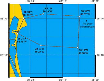
United States Coast Guard broadcasts this launch information on Marine Band Channel 16. Launch of a Delta 2 booster carrying MAP satellite is scheduled during a window of 3:46 to 3:58 p.m. EDT. For their safety, mariners are asked to remain clear of the LHA beginning approximately two hours prior to the opening of the launch period, and stay clear of the area until approximately one and one half hours after the period closes. The LHA extends approximately 65 miles Northeast of Port Canaveral. Persons entering an active Launch Hazard Area should be aware that severe civil and criminal penalties are authorized to punish violators. In accordance with Title 33, United States Cede, Section 1232, the maximum penalty is six years confinement and a $250,000 fine.
|
Flight Data File Vehicle: Delta 2 (7425) Payload: MAP Launch date: June 30, 2001 Launch time: 3:46:46 p.m. EDT (1946:46 GMT) Launch site: SLC-17B, Cape Canaveral, Florida Satellite broadcast: GE-2, Trans. 9, C-band Pre-launch briefing Launch timeline - Chart with times and descriptions of events to occur during the launch. Ground track - Trace the Delta rocket's trek during launch. Delta 2 rocket - Overview of the Delta 2 7425-model rocket used to launch MAP. Microwave Anisotropy Probe - Technical look at the spacecraft and its systems. Mission science - Overview of the scientific objectives of MAP. Delta directory - See our coverage of preview Delta rocket flights. |
||||
|
MISSION STATUS CENTER |
|||||