|
|
|
|
|
Shorefront property, anyone? CASSINI PHOTO RELEASE Posted: September 30, 2006
Centered near 74 degrees north, 65 degrees west longitude, this lake is roughly 20 kilometers by 25 kilometers (12 to 16 miles) across. It features several narrow or angular bays, including a broad peninsula that on Earth would be evidence that the surrounding terrain is higher and confines the liquid. Broader bays, such as the one seen at right, might result when the terrain is gentler, as for example on a beach.
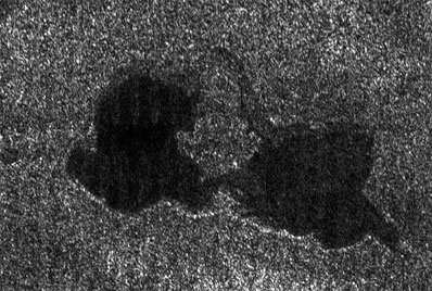
This Cassini radar image shows two lakes "kissing" each other on the surface of Saturn's moon Titan. The image from a flyby on Sept. 23, 2006, covers an area about 60 kilometers (37 miles) wide by 40 kilometers (25 miles) high. This pass was primarily dedicated to the ion and neutral mass spectrometer instrument, so although, the volume of radar data was small, scientists were amazed to see Earth-like lakes. With Titan's colder temperatures and hydrocarbon-rich atmosphere, however, the lakes likely contain a combination of methane and ethane, not water. In this image, near 73 degrees north latitude, 46 degrees west longitude, two lakes are seen, each 20 to 25 kilometers (12 to 16 miles) across. They are joined by a relatively narrow channel. The lake on the right has lighter patches within it, indicating that it may be slowly drying out as the northern summer approaches. The Cassini-Huygens mission is a cooperative project of NASA, the European Space Agency and the Italian Space Agency. The Jet Propulsion Laboratory, a division of the California Institute of Technology in Pasadena, manages the mission for NASA's Science Mission Directorate, Washington, D.C. The Cassini orbiter and its two onboard cameras were designed, developed and assembled at JPL. The radar instrument team is based at JPL, working with team members from the United States and several European countries. |
|
|
|
|
||||||||||||||||||||||