|
| ||
|
|
||
|
Overview of Terra spacecraft NASA FACT SHEET Posted: Dec. 15, 1999
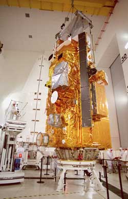
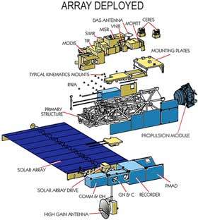
Terra is the flagship in a series of EOS spacecraft. Terra carries five state-of-the-art instrument sets with measurement and accuracy capabilities never flown before, enabling it to observe the cycling of water, trace gases, energy, and nutrients throughout the Earth's climate system. This comprehensive approach to data collection enables scientists to study the interactions among the four spheres of the Earth system - the oceans, lands, atmosphere, and biosphere. Terra simultaneously will study clouds, water vapor, small particles in the atmosphere (called "aerosol" particles), trace gases, land surface and oceanic properties, as well as the interaction between them and their effect on the Earth's energy budget and climate. Moreover, Terra will observe changes in the Earth's radiation energy budget - which is the amount of incoming energy from the sun minus outgoing energy from reflected sunlight and emitted heat. If we are to succeed in building predictive computer models of these complex interactions, we must clearly comprehend global climatic processes and parameters. The Terra team estimates that it will complete the first Earth system models within five years after launch. Mission facts A polar-orbiting spacecraft, Terra is scheduled for launch in late of 1999 aboard an Atlas IIAS launch vehicle from Vandenberg Air force Base, Calif. Synchronized with the sun, Terra's descending orbit will cross the equator at 10:30 a.m. local time during each orbit - hence the original term "AM." Clouds typically form over tropical land in the afternoon as the surface warms, creating updrafts; hence, Terra's morning view will provide clearer images of the Earth's lands. The satellite will orbit the Earth once every 99 minutes at an inclination of 98 degrees relative to the equator, at a mean altitude of 438 nautical miles (705 kilometers). Over the tropical oceans, there are fewer clouds in the afternoon. Terra will be followed by its "PM" spacecraft counterpart in the year 2000. EOS PM-1 will fly in an ascending orbit with a 1:30 p.m. equatorial crossing time, thus complementing and extending Terra's measurement capabilities. Terra is a joint project between the United States, Japan, and Canada. The U.S. provided the spacecraft and three instruments developed by NASA Field Centers - the Clouds and the Earth's Radiant Energy System (CERES), the Multi-angle Imaging SpectroRadiometer (MISR), and the Moderate-resolution Imaging Spectroradiometer (MODIS). Langley Research Center, Hampton, Va. provided two CERES units, the Jet Propulsion Laboratory, Pasadena, Calif., provided MISR, and Goddard Space Flight Center provided the MODIS instrument. The Japanese Ministry of International Trade and Industry provided the Advanced Spaceborne Thermal Emission and Reflection Radiometer (ASTER). The Canadian Space Agency provided an instrument called Measurements of Pollution In The Troposphere (MOPITT). NASA's Kennedy Space Center, Fla., will conduct launch operations using the Atlas launch vehicle under a contract with Lockheed Martin Astronautics, Denver. Goddard will operate Terra via the Tracking and Data Relay Satellite System. It also will receive, process, and disseminate science data through the geographically distributed Earth Observing System Data and Information System (EOSDIS). EOS is managed by Goddard for NASA's Earth Science strategic enterprise, Washington, D.C.
Terra's instruments The CERES instruments will measure the reflected and radiant energy coming from the Earth's surface and atmosphere, helping us to better determine our planet's energy balance. The critical components that affect the Earth's energy balance are the planet's surface, atmosphere, aerosols, and clouds. CERES will extend the data set begun in the 1980s by NASA's Earth Radiation Budget Experiment (ERBE). With cameras pointed in nine different viewing directions, the MISR instrument will measure every part of the Earth system that scatters light differently at different angles: clouds, Earth's surface, and particles floating in the atmosphere. Measuring the reflective characteristics of each of these will help us learn about their changing physical properties, as well as quantify their impacts on Earth's energy budget. MISR also will provide unique three-dimensional views of clouds and volcanic plumes. The MODIS instrument will measure the atmosphere, land, and ocean processes. This includes surface temperature (both the land and ocean), ocean color, global vegetation, cloud characteristics, snow cover, and temperature and moisture profiles. MODIS is capable of viewing the entire globe daily at moderate resolutions, ranging from 250-meters square to 1-kilometer square (about 0.5 square miles) pixels. MODIS is a global-scale, multi-spectral instrument useful for addressing questions in many scientific disciplines. The MOPITT instrument is an infrared gas-correlation radiometer that will measure gaseous concentrations of carbon monoxide and methane (important air pollutants) in the lower atmosphere (troposphere), the lowest 10 miles of the atmosphere. MOPITT will provide global data on these pollutants as to their location on the planet and the season. NASA supports about 800 scientists from the United States and abroad to meet global change research objectives using Terra data.
|
Flight data file Vehicle: Atlas 2AS Payload: Terra Launch date: Dec. 16, 1999 Launch window: 1833-1858 GMT (1333-1358 EST) Launch site: SLC-3E, Vandenberg Air Force Base, Calif. Pre-launch briefing Atlas vehicle data - Overview of the rocket that will launch Terra into space. Launch timeline - Chart with times and descriptions of events to occur during the launch. Pre-launch photo gallery - Follow the rocket and satellite preparations for launch in pictures. Terra's mission - A NASA release detailing the objectives and science goals of Terra. NewsAlert Sign up for Astronomy Now's NewsAlert service and have the latest news in astronomy and space e-mailed directly to your desktop (free of charge). |
|||||||
|
ATLAS INDEX |
||||||||