|
|
|
|
|
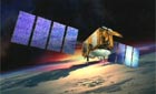
Jason 2 satellite begins mapping Earth's oceans NASA/JPL NEWS RELEASE Posted: July 30, 2008 WASHINGTON -- Less than a month after launch, the NASA-French space agency Ocean Surface Topography Mission (OSTM)/Jason 2 oceanography satellite has produced its first complete maps of global ocean surface topography, surface wave height and wind speed.
The new mission extends a 16-year continuous record of global sea level measurements begun in 1992 by the NASA/Centre National d'Etudes Spatiales (CNES) TOPEX/Poseidon mission and continued by the two agencies on Jason 1, launched in 2001. Data from TOPEX/Poseidon and Jason 1 shows that mean sea level has been rising by about .12 inches a year since 1993. The new maps were generated from the first 10 days of data collected once the new satellite reached its operational orbit of 830 miles on July 4. OSTM/Jason 2 and its predecessor, Jason 1, now are flying in formation in the same orbit approximately 55 seconds apart, making nearly simultaneous measurements that are allowing scientists to precisely calibrate the new satellite's instruments. Comparisons of data from the two satellites on sea-level anomalies, significant wave height and ocean wind speed all show very close correlation of all measured parameters. "These initial observations from OSTM/Jason 2 compare very closely to those of Jason 1," said Lee-Lueng Fu, OSTM/Jason 2 project scientist at NASA's Jet Propulsion Laboratory, Pasadena, Calif. "To be able to collect such high-quality science data within a month of launch breaks previous records. It is also a direct reflection of how mature the field of satellite altimetry has become and of the seamless cooperation of our international team." The satellite's first radar altimeter data were acquired just 48 hours after its launch on June 20 from Vandenberg Air Force Base, Calif., on a Delta II rocket. CNES processed the first test results, followed by more advanced data results a week after launch. The more advanced results were produced after calculating the precise location of the satellite's preliminary orbits. The satellite, its instruments and ground segment all are functioning properly. After it has been fully calibrated and validated, the satellite will begin providing oceanographic products to users around the world. OSTM/Jason 2 is an international endeavor, with responsibilities for satellite development and launch shared between NASA and CNES. CNES provided the OSTM/Jason 2 spacecraft, NASA provided the launch, and NASA and CNES jointly provided the primary payload instruments. CNES and the National Oceanic and Atmospheric Administration (NOAA) are responsible for satellite operations, while JPL is managing the mission for NASA. Data processing is being carried out by CNES, the European Organisation for the Exploitation of Meteorological Satellites (EUMETSAT) and NOAA, depending on the type of product. After on-orbit commissioning of OSTM/Jason 2 is completed, CNES will hand over mission operations and control to NOAA, which then will join with EUMETSAT to generate, archive and distribute data products to users worldwide. |
|
|
|
|
|||||||||||||||||||||||||||||||||||||||||