|
 |
|
||||
|
|
||||
|
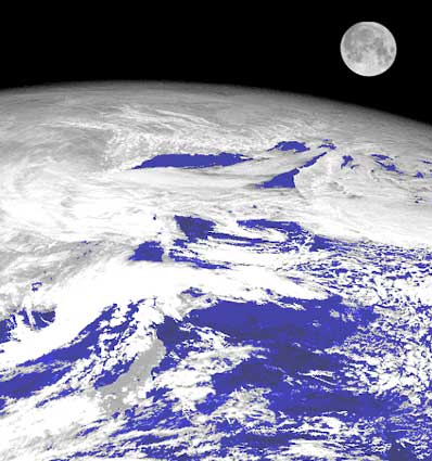
Looking to the moon for better satellite images CSIRO NEWS RELEASE Posted: August 24, 2001 For the first time, the Commonwealth Scientific and Industrial Research Organisation (CSIRO) of Australia and U.S. scientists are using the moon to check and calibrate sensors on board weather satellites. The 'moon tuned' sensors are expected to provide a wealth of improved information about climate change and air pollution.
"The moon's surface is bare and unchanging and there is no air between it and the satellite." In the past, scientists have calibrated satellite sensors by checking their views of uniform targets on Earth, such as deserts or clouds. However, the atmosphere gets in the way and vegetation and rainfall can alter the appearance of deserts. "We are doing lunar calibrations with the imager on the Japanese Geostationary Meteorological Satellite. This is the imager that gives us the pictures of clouds over Australia that we see on TV weather reports," says Dr Grant. Although the moon's surface is unchanging, the brightness of any point on the moon changes with the direction of sunlight and the direction from which the satellite looks. The U.S. Geological Survey accurately maps the moon's brightness from its lunar observatory in Arizona. The satellite imager is calibrated at times when its view of the moon matches the view angle of instruments at the observatory. "In future, we'll be able to check the imager from a range of viewing angles," says Dr Grant. Additionally, the newly calibrated satellite sensor will be able to more accurately monitor smoke plumes from large fires that are prevalent in the tropics. Climate scientists are especially interested in the way in which such smoke can affect global warming. Dr Grant presented this breakthrough in satellite imager calibration at a recent international remote sensing conference in Australia. He collaborated on the research with a team led by Dr Hugh Kieffer from the U.S. Geological Survey. There are currently eight geostationary meteorological satellites in orbit,
and the lunar technique could be used in future to calibrate all of them.
This will make their data more consistent and accurate, and so better able
to monitor global climate and smoke plumes.
|
|
||||