Satellite images tell tale of Wisconsin tornado
UNIVERSITY OF WISCONSIN-MADISON NEWS RELEASE
Posted: June 27, 2001
The morning after the northwestern Wisconsin town of Siren was leveled by a
devastating tornado, the federal Landsat-7 satellite captured its destructive
path from space.
The orbit of the satellite, which makes a 16-day pass of the globe, just
happened to coincide with the morning after the June 18 storm. That set the
stage for researchers at the Environmental Remote Sensing Center to construct
a high-resolution before-and-after documentation of the storm's damage.
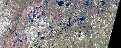
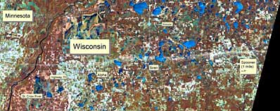
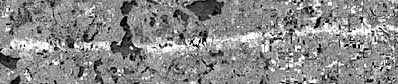
TOP: Landsat-7 satellite image from May 18, 2001 showing conditions on the land prior to the tornado. The image covers an area of northern Wisconsin approximately 50 miles in the east-west direction and 20 miles in the north-south direction. MIDDLE: Image from June 19 showing conditions one day after the Siren, Wis. tornado. The bright path of greatest destruction shows a change in land reflectance and can be seen running roughly parallel to Highway 70, from just east of Alpha to the eastern edge of the image, just southwest of Spooner, Wis. BOTTOM: This comparative statistical analysis of the change in land reflectance between two Landsat-7 satellite images. Credit: Image courtesy USGS EROS Data Center with processing by Environmental Remote Sensing Center, University of Wisconsin-Madison
|
"Timing is everything when trying to document these events via satellite,"
says Thomas Lillesand, director of the remote sensing center, part of the
Institute for Environmental Studies. "We were fortunate to have cloud-free
images of the area collected both the day after the tornado and essentially
one month earlier. We could then register the two images and highlight the
damaged areas using digital image processing techniques."
Lillesand and his fellow researchers have extensive experience in processing
satellite data for a range of environmental monitoring and natural resource
management applications. For example, Landsat data are being used to measure
the transparency of Wisconsin's more than 15,000 lakes.
This cooperative effort is being conducted jointly with the Wisconsin
Department of Natural Resources and the hundreds of citizen volunteers who
participate in the DNR Self-Help lake monitoring program. UW-Madison's
ongoing water quality research is known as the Satellite Lake Observatory
Initiative.
|
|
|
|

|