|
 |
|
||||
|
|
||||
|
Movement of Earth's crust can be detected with GPS UNIVERSITY OF TORONTO NEWS RELEASE Posted: March 25, 2001
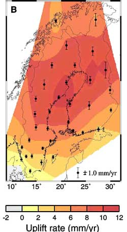
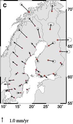
"We've taken advantage of the global positioning system (GPS) that's now used in cars and applied it to measuring the 'memory' of the Earth's crust to past events," says Jerry Mitrovica, U of T's J. Tuzo Wilson Professor in Geophysics. Mitrovica is one of the lead authors of a paper appearing in the March 23 issue of Science, which has been hailed as a landmark in space-based geophysical measurements. During the last Ice Age, Scandinavia -- like Canada -- was covered in sheets of ice that measured some three kilometres thick, he explains. As these ice sheets melted, the Earth responded by rebounding, springing back to towards its original position after the loads of ice that once pressed upon it were taken off. "The Earth is not just springing back vertically, though," says Mitrovica. "It is also springing out in a horizontal motion, and that's something we couldn't measure until we started using GPS. When used in cars, this system will tell a person where they are within a couple of metres on the Earth's surface. We've taken that a few steps further. With the same idea and more sophisticated tools, we've been able to detect motions less than a millimetre per year. And that data is able to tell us conclusively just how stable a region of land really is." Mitrovica conducted the research with Glenn Milne of the University of Durham, James Davis of the Harvard-Smithsonian Center for Astrophysics, Hans-Georg Scherneck and Jan Johansson of Onsala Space Observatory, and Martin Vermeer and Hans Koivula of the Helsinki University of Technology.
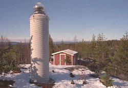
In 1993, after obtaining several million dollars of funding from Swedish, Finnish and American funding agencies, the group installed advanced climate-controlled GPS sensors and put their theory to the test. For the past six years, 34 GPS sensors situated throughout Sweden and Finland have each been continuously recording observations from up to 10 satellites simultaneously. In total, 24 satellites -- each orbiting the Earth at a distance of about 26,000 kilometres -- were used. According to Mitrovica, there are some scientists who believe that Sweden and Finland are subject to potentially hazardous tectonic motions. While the countries are not near tectonic plate boundaries, there was a belief that large faults ran through the area that caused motions in the range of several millimetres per year. "That's important because if you're building a nuclear power plant, for example, you want to know the stability of the region you're building in. This research shows that there is no evidence for tectonic faulting in Sweden. This is an incredibly stable region of the world that will not be faced with large earthquakes." Mitrovica says the same results would be seen in Canada. The difference, however, is that the rebound would cover a larger area and be centred over Hudson Bay.
"There was no way of knowing if sea level change was as a result of land popping up because of crustal rebound or global sea level rise, which made the tide gauge measurements unusable. But now, for the first time, scientists can use these measurements by using the GPS data to correct for rebound." The group determined that sea level in that area was, in fact, increasing by two millimetres per year, confirming research reported by Mitrovica, Milne and Davis in a paper published in the Feb. 22 issue of Nature. Mitrovica says this research has far-ranging applications and can be used
in any other region of the Earth where tectonic stability is in question.
This study was funded by the National Aeronautics and Space Administration
and the National Sciences Foundation in the U.S., the Natural Science
Research Council of Sweden, Posiva Oy of Finland, the Natural Science and
Engineering Research Council of Canada, the Natural Environment Research
Council of the U.K., the Smithsonian Institution, the Knuth and Alice
Wallenberg Foundation and the Canadian Institute for Advanced Research.
|
|
|||||||||