|
|
||
|
|
||
|
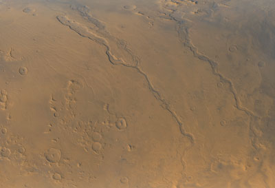
Spacecraft captures postcard view of Martian valleys NASA/JPL/MSSS PHOTO RELEASE Posted: October 6, 2000 At the beginning of its fourth year in orbit around the Red Planet, NASA's Mars Global Surveyor spacecraft has snapped a picture-postcard view of three Martian valleys. The three major valley systems are located east of the Hellas plains.
These valleys are believed by some to have been formed -- at least in part -- by large outbursts of liquid water some time far back in the martian past, though there is no way to know exactly how many hundreds of millions or billions of years ago this might have occurred. In each valley, water would have flowed toward the bottom of the image. Although their dimensions vary along their courses, the valleys are all roughly 1 km (0.6 miles) deep and range in width from about 40 km (25 miles) down to about 8 km (5 mi). Located around 40 degrees S, 270 degrees W, the picture covers an area approximately 800 km across and is illuminated by sunlight from the lower left. Malin Space Science Systems and the California Institute of Technology built the MOC using spare hardware from the Mars Observer mission. MSSS operates the camera from its facilities in San Diego, CA. The Jet Propulsion Laboratory's Mars Surveyor Operations Project operates the Mars Global Surveyor spacecraft with its industrial partner, Lockheed Martin Astronautics, from facilities in Pasadena, CA and Denver, CO.
|
|
||||