|
|
||
|
|
||
|
IMAGE gives first view of electrified gas around Earth NASA/GODDARD NEWS RELEASE Posted: June 1, 2000
"IMAGE is the first weather satellite for space storms," said Dr. James L. Burch, Principal Investigator for IMAGE at Southwest Research Institute, San Antonio, Texas. "This revolutionary spacecraft makes these invisible storms visible. In a sense, IMAGE allows us to view the Earth through plasma-colored glasses. We eagerly anticipate the arrival of severe solar weather associated with solar maximum, which we are now entering." Previous spacecraft explored this turbulent region by detecting particles and fields as they passed through them. This technique limited their vision to small portions of this vast and dynamic region, extending beyond the Moon on the Earth's night side.
The initial pictures from IMAGE were presented at a press conference during the spring meeting of the American Geophysical Union on May 31 at 2 p.m. EDT in Washington, D.C. "These first images are an enticing glimpse at the spectacular results expected from IMAGE once we encounter really heavy weather in space," said Dr. James Green, Deputy Project Scientist for IMAGE at Goddard. All spacecraft systems have been successfully deployed and are operating normally. All scientific instruments are operating as expected and are returning images.
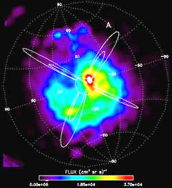
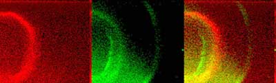
A suite of three Neutral Atom Imaging instruments is recording the glow of fast atoms coming from throughout the Earth's magnetic field. This reveals the shape and motion of the clouds of plasma that make up a magnetic storm. The Far Ultraviolet Imaging instrument is collecting the first-ever images from space of the Earth's proton aurora. The aurora, commonly known as the northern and southern lights, is a ghostly light show seen most often at high latitudes of Earth. The dance of lights that is visible from the ground is caused by electrons striking and lighting up the atmosphere much like electricity lights up a television screen. The proton aurora is invisible to the naked eye and has never been viewed from space; from the ground, it is visible only in far-ultraviolet wavelengths.
The Radio Plasma Imager instrument provides a three-dimensional view of the plasmasphere by sounding it with radio pulses, like an ultrasound image of the human body. To accomplish this, it uses the longest antennas ever deployed in space, longer than the height of the Empire State Building. |
Video vault PLAY (215k, 25sec QuickTime file) PLAY (179k, 12sec QuickTime file) Download QuickTime 4 software to view these files. Photo gallery Launch - Pictures from the countdown and liftoff of Delta 2 with IMAGE. Previous coverage Launch story - Our full report on IMAGE's journey to space. Mission Status Center - Our play-by-play reports on the countdown and launch. IMAGE - Description of the satellite and its science mission. Launch timeline - Chart with times and descriptions of events to occur during the launch. Orbit trace - Maps showing the ground track the rocket will follow during flight. Delta 2 rocket - Overview of the Delta 2 7326-model rocket used to launch IMAGE. Explore the Net IMAGE - NASA site gives overview of Imager for Magnetopause-to-Aurora Global Exploration mission. SwRI - The official IMAGE mission home page at Southwest Research Institute. LMMS - Lockheed Martin Missiles & Space built IMAGE. Explorers Program - NASA/Goddard Space Flight Center site devoted to Explorer missions. Delta 2 - Official Web site of Boeing's Delta 2 expendable launch vehicle program. |
||||||||||