|
 |
|
||||
|
|
||||
|
Spirit headed to Gusev FROM NASA PRESS KIT Posted: December 31, 2003 Selection of landing sites for the two Mars Exploration Rovers required more than two years of intensive study. More than 100 scientists and engineers participated in evaluating sites both on the basis of favorable criteria for safe landings and on the prospects for outstanding science opportunities after the rovers reach the ground. To qualify for consideration, candidate sites had to be near Mars' equator, not too rugged, not too rocky, not too dusty, and low enough in elevation so the spacecraft would pass through enough atmosphere to slow down sufficiently. In all, 155 potential sites met the initial safety constraints. Detailed observations by two active orbital spacecraft, Mars Global Surveyor and Mars Odyssey, provided an unprecedented amount of information for evaluating finalist candidate sites. The pair that made the final cut satisfied all the safety criteria; they also show powerful evidence of past liquid water, but in two very different ways.
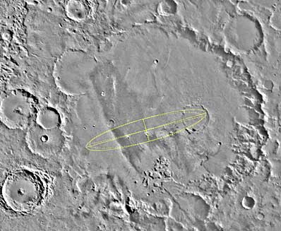
An asteroid or comet impact perhaps as much as 4 billion years ago dug Gusev Crater. Many smaller, younger impact craters pock Gusev's 150-kilometer-diameter (95-mile) floor. One of the largest branching valleys on Mars, likely carved by flowing water more than 2 billion years ago, leads directly into Gusev Crater through a breach in the crater's southern rim. Gusev sits at 15 degrees latitude south of Mars' equator at longitude 184.7 degrees west, in a transition zone between the ancient highlands on the southern part of the planet and smoother plains to the north. The valley, called Ma'adim Vallis, snakes northward Nile-like about 900 kilometers (550 miles) from the highlands to Gusev. In places, it gapes more than 25 kilometers (16 miles) wide and 2 kilometers (1.2 miles) deep. Water flowing down the valley would have pooled in Gusev Crater, dropping sediments there before exiting through a gap in the crater's northern rim. Comparable crater lakes, such as Lake Bosumtwi in Ghana, exist on Earth. Gusev's lake, if indeed it did exist, is now gone. But the floor of Gusev Crater may hold water-laid sediments that preserve records of the lake environment, of the sediments' highlands origins and of the sediments' river trip. As a potential complication, sedimentary layers may lie buried under later deposits from volcanic eruptions or wind-blown dust. If so, the best chances for finding sedimentary rocks may be in material thrown outward when younger craters were excavated by impacts that punched through the covering layers. The targeted landing area for Spirit is an ellipse about 78 kilometers (48 miles) long and 10.4 kilometers (6.5 miles) wide near the center of Gusev Crater. Several small craters in and near the ellipse have likely stirred up rocks from underneath the top veneer of Gusev's flat floor. Whether they have dug deep enough to expose lake-related material if volcanic overburden is deep remains to be seen. A Mars Exploration Rover is well equipped to pursue clues to Gusev's past environment. The panoramic camera and miniature thermal emission spectrometer will scan the scene for an initial survey of the surroundings after landing. Decisions about where to drive Spirit and how to use its other tools will depend on what that survey shows, such as whether any sedimentary rocks appear to be accessible. As the rover drives to new locations during its planned three months of Mars surface operations, a succession of further panoramic surveys will multiply the number of candidate rocks to consider for up-close examination. If Spirit can find and approach sedimentary samples, several physical traits that the panoramic camera and the microscopic imager could reveal might testify about the long-ago environment. The rock abrasion tool could provide the cameras with fresh, unweathered surfaces to examine. The types of traits scientists may be checking for include:
Spirit's miniature thermal emission spectrometer, alpha particle X-ray spectrometer and Mossbauer spectrometer could provide a different set of clues about Gusev Crater's past. These three instruments analyze the composition of rocks and soils. Scientists may use them to look for evidence such as:
The geographical coordinates for the center of Spirit's landing ellipse target are 14.59 degrees south latitude and 175.3 degrees east longitude. Gusev Crater was named in 1976 for Russian astronomer Matvei Gusev, who lived
from 1826 to 1866. Ma'adim Vallis takes its name from the Hebrew word for Mars.
|
|
||||
|
MISSION STATUS CENTER |
|||||