|
 |
|
||||
|
|
||||
|
The NAVSTAR Global Positioning System U.S. AIR FORCE FACT SHEET Posted: January 26, 2003
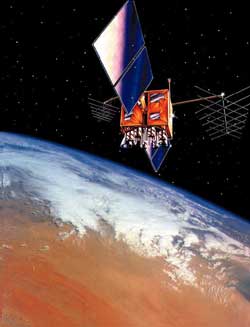
NAVSTAR GPS is a space-based radio-positioning system nominally consisting of a constellation of 24 orbiting satellites that provide navigation and timing information to military and civilian users worldwide. In addition to the satellites, the system consists of a worldwide satellite control network and GPS receiver units that pick up signals from the satellites and translate them into position information. Delta 2 expendable launch vehicles are used to launch the GPS satellites from Cape Canaveral Air Force Station, Fla., into six circular orbits of nearly 11,000 nautical miles. GPS provides the following:
GPS satellites orbit the earth every 12 hours, emitting continuous navigation signals on two different L-band frequencies. The signals are so accurate, time can be figured to within a millionth of a second, velocity can be figured to within a fraction of a mile per hour, and location can be figured to within meters. Positioning accuracy for military users is nominally 16 meters, while accuracy for civilian users is nominally 100m. There are four generations of the GPS satellite: the Block 1, the Block 2/2A, the Block 2R, and the Block 2F. Block 1 satellites were used to test the principles of the Global Positioning System, and lessons learned from these 11 satellites were incorporated into later blocks. Block 2 and 2A satellites make up the current constellation. A total of 28 were put on contract, with the last four tagged as replacements for earlier satellites reaching the end of their service life. Block 2R satellites boast dramatic improvements over the previous blocks of satellites, and will have the ability to determine their own position by performing inter-satellite ranging with other 2R vehicles, reprogrammable satellite processors enabling problem fixes and upgrades in flight, and increased satellite autonomy and radiation hardness. Additionally, the Block 2R has the ability to be launched into any of the required GPS orbits at any time with a 60-day advanced notice and requires many fewer ground contacts to maintain the constellation. All of these improvements result in increased accuracy for GPS users at a cost of 33 percent less per satellite than the previous generation of Block 2A satellites. Block 2R satellites will replace Block 2/2A satellites as they reach the end of their service life. Block 2F satellites are the fourth generation of the navigation satellite and will be used as sustainment vehicles. Improvements in the Block 2F over previous satellites include a design life of 12.7 years and a dramatic increase in the growth space for additional payloads and missions. GPS significantly outperforms other position and navigation systems, and it does so with greater accuracy and at a lower cost. Such endeavors as mapping, aerial refueling, rendezvous operations, geodetic surveying, and search and rescue operations have all benefited greatly from GPS's accuracy. Using lessons learned from Operations Desert Shield and Desert Storm, GPS is being integrated into nearly all facets of the modern battlefield. Forward air controllers, pilots, tank drivers, and ground troops all use GPS to help ensure victory on the battlefield. The GPS worldwide satellite control system consists of five monitor stations and four ground antennas. The monitor stations use GPS receivers to passively track the navigation signals of all the satellites. Information from the monitor stations is then processed at the master control stations, operated by the 2nd Space Operations Squadron at Schriever Air Force Base, Colo., and used to very accurately update the satellites' navigation messages. Updated navigation information is sent to the GPS satellites from the Master Control Station at Schriever Air Force Base through ground antennas using an S-band signal. The ground antennas are also used to transmit commands to satellites and to receive the satellites' state-of-the-art telemetry data.
|
Flight Data File Vehicle: Delta 2 (7925-9.5) Payload: GPS 2R-8 Launch date: Jan. 29, 2003 Launch window: 1:06-1:20 p.m. EST (1806-1820 GMT) Launch site: SLC-17B, Cape Canaveral, Florida Satellite broadcast: AMC 2, Transponder 4, C-band Pre-launch briefing Launch timeline - Chart with times and descriptions of events to occur during the launch. GPS constellation - Chart shows the current status of the orbiting GPS satellite fleet. XSS-10 - The experimental microsatellite flying as a secondary payload on this launch. Delta 2 rocket - Overview of the Delta 2 7925-model rocket used to launch GPS satellites. SLC-17 - The launch complex where Delta rockets fly from Cape Canaveral. Delta directory - See our coverage of preview Delta rocket flights. Earth Calendar  NEW! This amazing 2003 calendar features stunning images of mountain ranges, volcanoes, rivers, and oceans obtained from previous NASA space shuttle missions�.��
Hubble Calendar  NEW! This remarkable calendar features stunning images of planets, stars, gaseous nebulae, and galaxies captured by NASA's orbiting Hubble Space Telescope�.��
Hubble Posters  Stunning posters featuring images from the Hubble Space Telescope and world-renowned astrophotographer David Malin are now available from the Astronomy Now Store. Stunning posters featuring images from the Hubble Space Telescope and world-renowned astrophotographer David Malin are now available from the Astronomy Now Store. |
|||||
|
MISSION STATUS CENTER |
||||||