|
|
|
|
|
U.S. military's new weather satellite gets foggy sendoff BY JUSTIN RAY SPACEFLIGHT NOW Posted: October 18, 2009 An Atlas 5 rocket escaped the heavy blanket of fog smothering its launch pad this morning and successfully powered to space to deploy a new global weather observatory for America's military. Liftoff from California's Vandenberg Air Force Base came at 9:12 a.m. local (12:12 p.m. EDT; 1612 GMT) when the day's narrow launch window opened to ensure delivery of the payload into the desired polar orbit.
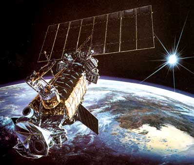
About 18 minutes into the flight, the Defense Meteorological Satellite Program F18 spacecraft successfully released from the rocket to begin its $500 million mission to track the weather across the planet. "This is an incredibly important mission for our nation," said Col. Michael Moran, the Atlas Group commander. "Little happens on today's battlefield without a very clear picture of the weather." "As a weather satellite, we tend to get just a little respect. It's certainly not as sexy a mission as some -- GPS, for example, which is famous around the world now," said Col. Stephen Pluntze, Defense Meteorological Satellite Systems Group commander at Los Angeles Air Force Base. "DMSP has been providing weather-related data to the nation for nearly 50 years. These satellites are optimized for the military but they also provide civilian forecasters with information about developing terrestrial weather and space weather, the existing weather systems over remote areas on the Earth and anticipated hazards to people and our resources. The weather-related data has provided improved ways of detecting severe weather fronts and determining their strength." Unlike the civilian geostationary satellites parked 22,300 miles above Earth to focus on one region of the planet and capture the imagery of clouds seen on television weather reports, the military's DMSP satellites fly far closer to the ground and see virtually the entire globe twice daily. "With the lower altitude, the data fidelity is much higher, we're just closer. It's a close-up picture vs. one that's farther away. And because we cover the whole Earth, we are much more responsive to the military's requirements as far as targeting different areas and being able to look at different things at different times rather than staring at one place," Pluntze said. The orbiting eyes help plan air, sea and land operations by U.S. military forces deployed around the world. "We try to bring weather guys who were over in Iraq or Afghanistan to some of our briefings because as you can expect the contractors who work on these satellites would like know that they're doing a good job for somebody. So my stories are mostly come from folks like that - they've been in the desert and have used weather operationally, which means to plan missions," Pluntze said. "One of the areas where this satellite has come in very handy is for sand storms. If you know a sand storm is about to end and your enemy doesn't, you can do a lot with that information, or conversely, you know one is about to start and he doesn't. The same information is true about flying (unmanned aerial vehicles). UAVs are of course smaller, more fragile than normal manned airplanes. So if you know if the weather is either going to be good or poor for their use but your enemy doesn't, then you can keep him guessing. Those are great multipliers for the weather mission."
It was October 18, 2003 when DMSP F16 roared away from Vandenberg atop a Titan 2 booster after multiple trips to the launch pad and countdowns spread across 33 months. The seemingly jinxed satellite had gotten within 28 seconds of blastoff in early 2001, but that day's scrub was just one chapter in the long saga of delays. A full recap about the satellite's infamous hard luck can be read here, along with another article from the day DMSP F16 eventually launched. The memories about trying to get the satellite into space come flooding back now that its successful mission transitions into a new phase. Having surpassed its design life, the Air Force will make DMSP F18 the new leader in F16's orbit. At the moment of today's launch, DMSP F16 was 461 nautical miles over the Middle East in its pole-to-pole orbit. DMSP satellites circle around the planet to collect global weather data for the U.S. military to use in planning operations across the world. The satellites are built by Lockheed Martin with an expectation to last four years but normally operate much longer. "F16 will be the one that this satellite replaces, although F16 will not stop working," Pluntze said.
"You know, it would be nice to be able to wait until one breaks before you replace it, then you are not losing anything, you've used up one totally and then the next one comes online and it takes over the mission. There's really no way to predict when the ones up there are going to fail. If you waited until they fail, it takes quite a long time to get a satellite ready for launching and we don't wait on the pad with the satellite ready to go. We tend to launch them before they are needed but there's really no way around that," Pluntze said. "It's a little bit of an art, not a science to figuring out when the older ones are old and when you need a new one. F16 is in decent shape. There were some improvements made to that satellite, so it's doing okay. But it's down now to its last gyroscope, which is what keeps the upside up and the downside down. So it is time to launch this one. The one that's up there won't break immediately, but it's getting to the point we realize it is time." The military currently uses four DMSP satellites ranging in age from the extraordinarily long-lived F13 launched in 1995 to the youngest, F17, deployed in 2006. The quartet is separated into pairs operating in two different orbits. Their instruments provide visible and infrared imagery of clouds, day or night, plus measure winds, soil moisture, ice and snow coverage, pollution, fires and dust storms. "We only need one satellite in each orbit to be working. We're lucky that we have more than that. So in this orbit we'll have F15, F16 and F18, after it gets up. The other orbit we have F13 and F17," Pluntze said.
"We do two missions -- terrestrial weather and space weather. The intent being you take data, you send it the ground and it's used for a couple of things. You can either improve your forecast models, being able to look out further in time, or you can use the data real-time to tell the warfighters where the weather is, what is going to happen to it and how you can use that on the battlefield," Pluntze said. "Space weather data, that's not like a forecast for the Earth or the planetary surface. You are still trying out what's going to happen hours or days ahead, but our space forecasting models are not as good as our terrestrial models. So any and all data we get improves those models. That's probably the most important thing right now. In the future, as we get better with the models and we can predict where space weather is going to act up, then we can tell people using radios and radars and power facilities on the ground where and when they may act up." There are two more DMSP satellites built to fly in the coming years. Tentative plans call for F19's launch in October 2012 and F20's in May 2014. "We've have been able to make the old ones last quite a long time. I applaud the ground crews who are very flexible and taking instruments that should not have lasted this long and figuring out new ways, sometimes with software, sometimes with on-orbit fixes, to keep them going a long time. They are all to be congratulated, but eventually you need the new ones and we're fortunate to have some new ones to go up," Pluntze said. "We are very proud of the DMSP legacy in providing this weather mission for the nation."
"From its begins in the late 1950s, the Atlas program has evolved to meet the challenges of spacelift into the 21st century," Moran said. Launch No. 601 is targeted for the early morning hours of November 14 from Florida's Cape Canaveral with the Intelsat 14 satellite, a commercial spacecraft to provide communications services to the Americas, Africa and Europe. The next Atlas slated to fly from Vandenberg will be a classified National Reconnaissance Office mission next October, Moran said.
|
|
|
|
||||||||||||||||||||||||||||
|
MISSION STATUS CENTER |
|||||||||||||||||||||||||||||||||