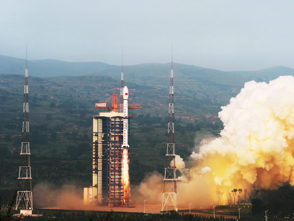
A Long March 4C rocket took off from northern China on Tuesday and deployed a radar imaging satellite into orbit about 460 miles above Earth to survey the oceans, crops and resources, and natural disasters.
The three-stage launcher thundered away from the Taiyuan space center 2255 GMT (6:55 p.m. EDT) Tuesday, Chinese state media reported, then turned south to place the Gaofen 3 spacecraft into polar orbit.
Liftoff occurred at 6:55 a.m. Beijing time Wednesday.
Tracking data published by the U.S. military’s Joint Space Operations Center indicated the Long March 4C rocket placed the Gaofen 3 satellite into orbit at an altitude of nearly 460 miles (740 kilometers). The craft is circling Earth at an inclination of 98.4 degrees to the equator.
The civilian-operated Gaofen 3 satellite is starting an eight-year mission to capture high-resolution all-weather imagery of Earth from its perch in orbit. Carrying a C-band synthetic aperture radar, Gaofen 3 weighs nearly 3 metric tons — about 6,500 pounds — and should help Chinese authorities better respond to natural disasters like earthquakes and floods, officials said.
Joining a fleet of optical and infrared imaging satellites under the Chinese government’s Gaofen program, the new satellite will focus on gathering imagery day and night, regardless of weather conditions. The all-weather capability of radar imaging will give officials updated information even if clouds or rain showers block the view of space-based optical cameras.
Made by the China Academy of Space Technology, Gaofen 3 is the sixth satellite to launch in the Gaofen series. It is also the first civilian Earth observation satellite with radar imaging.
“The satellite will provide high-quality, reliable and quantitative images for ocean monitoring, water conservancy monitoring and disaster monitoring, which will give strong technological support to building our maritime strength and the One Belt One Road project,” said Wu Yanhua, deputy head of China’s State Administration of Science, Technology and Industry for National Defense (SASTIND), in an interview with Chinese state television.
Gaofen 3 is part of the China High-resolution Earth Observation System, or CHEOS, a network of satellites supplying near-realtime data to Chinese government agencies such as the State Oceanic Administration, the Ministry of Civil Affairs, the Ministry of Water Resources, the China Meteorological Administration, and other sectors, according to a statement issued by SASTIND.
Gaofen 3’s radar instrument has 12 imaging modes, ranging from wide-area imaging to close-up shots with a best resolution of 1 meter, or approximately 3.3 feet. That will allow the spacecraft to provide clear views of roads, buildings and boats, China’s official Xinhua news agency reported.
As Gaofen 3 zooms around Earth, its radar instrument will scan along the satellite’s ground track, measuring microwave beams reflected off the planet’s land and water surfaces to create a map of structures, ships and urban infrastructure.
Tuesday’s liftoff of Gaofen 3 came four days after the last Chinese space launch, which lofted the country’s first mobile telecommunications satellite.
Email the author.
Follow Stephen Clark on Twitter: @StephenClark1.