![This full resolution subset of the first Sentinel 1B image captured Thursday shows Norway’s Nordaustlandet island in the Svalbard archipelago, covered by the Austfonna ice cap. Contains modified Copernicus Sentinel data [2016], processed by ESA](http://spaceflightnow.com/wp-content/uploads/2016/04/Austfonna_ice_cap.jpg)
More than 30,000 users have signed up to access data acquired from Europe’s Sentinel satellites, and 5 petabytes of data have come from the Sentinel 1A satellite alone, according to European Space Agency officials managing the program.
“That’s a lot of demand because one user can be as big as Google, who is downloading systematically all of our data and has an archive of Sentinel data which is exactly as big as our archive, because they download everything,” said Guido Levrini, ESA’s manager of the Sentinel satellite program. “That only counts as one user, then you add another 29,999. But they’re not all as big as Google.”
Spaceflight Now members can read a transcript of our full interview with Guido Levrini. Become a member today and support our coverage.
The Sentinel satellites are part of the European Commission’s Copernicus program, a network of spacecraft and data processing centers that will comprise the world’s largest environmental satellite system in history.
The data on Earth’s oceans, ice masses, land surfaces and atmosphere is distributed for free to anyone registered with the Copernicus program.
“Let me make no bones about it, Copernicus is ambitious, and with the launch of Sentinel 1B, we have raised the threshold and stepped up the pace of delivering data from space,” said Peter Breger, deputy head of the Copernicus unit at the European Commission.
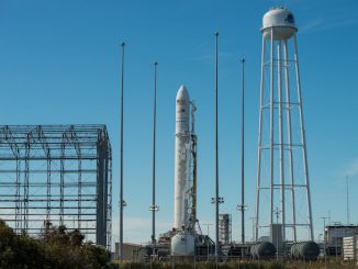
Sentinel 1B, the newest satellite in the network, launched Monday aboard a Soyuz rocket from French Guiana. On Thursday, the spacecraft’s radar instrument returned its first image.
The C-band radar transmits pulses of energy toward Earth and measures the signals that bounce off water, ice and soil to generate an image. It scans Earth in strips as the spacecraft circles the planet over the poles every 100 minutes.
The first 250-kilometer-wide (155-mile) image strip taken at 0537 GMT (1:37 a.m. EDT) Thursday sweeps north to south across the Barents Sea, including part of the Svalbard archipelago in the Norwegian Arctic. The full-resolution image is more than 70 megabytes in size, and can be downloaded here.
“It may feel a little like a routine because we launched three Sentinel satellites in less than 12 months, but of course it is not,” said Volker Liebig, ESA’s director of Earth observation programs, in a press release.
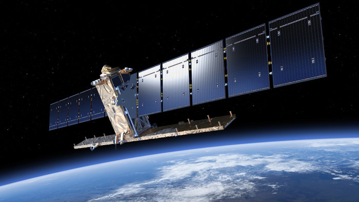
Engineers at the European Space Operations Center in Darmstadt, Germany, looked over the satellite as it completed a complex choreography of deployments in the first half-day after Monday’s launch. The C-band radar array, made by Airbus Defense and Space, launched folded up against the main body of the spacecraft with its power-generating solar panels.
The antenna’s five panels and the satellite’s solar array wings unfurled one step at a time to a length of 12 meters (40 feet) and 10 meters (33 feet), respectively.
“Getting a satellite into orbit is always thrilling, and every time we do this I am quite nervous,” Liebig said. “Our engineers and industry have shown what we can achieve with this fourth Sentinel delivering a first image in record time. We have another important part of the Copernicus missions in orbit. A great achievement from a great team.”
Manufactured by Thales Alenia Space, the 2,164-kilogram (4,770-pound) Sentinel 1B satellite is designed to function at least seven years, with propellant reserves for 12 years of operations. It will become operational in July after several months of tests and calibration.
In its most high-resolution mapping mode, the Sentinel radar returns images with a pixel size of 5 meters, or about 16 feet, with a swath width of 80 kilometers, or about 50 miles.
But the satellite can adjust the radar sensor to a wide-angle mode to see a strip of Earth as wide as 450 kilometers, or 280 miles, trading resolution for viewing area.
Radar imagery produced by the Sentinel 1 satellites is good for tracking ships, sea ice, earthquakes, volcanic activity, oil spills, and emergency response services.
![This full resolution subset of Sentinel 1B's first data take shows Edgeøya or Edge Island, which is one of the islands making up theSvalbard archipelago. Contains modified Copernicus Sentinel data [2016], processed by ESA.](http://spaceflightnow.com/wp-content/uploads/2016/04/Edgeoeya_or_Edge_Island.jpg)
Sentinel 1B is identical to the Sentinel 1A radar satellite launched in 2014, and the new craft will fine-tune its orbit to fly 180 degrees away from its partner nearly 700 kilometers (435 miles) above Earth. The positioning of the two satellites in orbit will drop the time it takes to get a new radar image of any place on Earth from 12 days to no more than six days, and as little as one to three days in polar regions.
Europe has developed a space-based communications network to help route Sentinel data from the satellites to ground stations using laser links, which transfer information at up to 1.8 gigabits per second, 90 times faster than a typical modern Internet connection.
The first laser relay station launched in January, and another one is due for launch next year to contend with the extensive Sentinel data haul.
“Up to now, in two years of operations, Sentinel 1A has generated 5 petabytes of data, which is a lot of data, much more than most end users are used to dealing with, and a magnitude more than what we have generated in the past with previous missions,” Levrini said. “Now, with the arrival of Sentinel 1B, the data production capability will be doubled.”
Spacecraft operators hope to increase the data intake of the Sentinel 1 satellites even more by the end of 2016, meaning additional radar imagery will funnel through the Copernicus data processing center to users.
“By the end of the year, we will generate three times as much data as generated today by the combination of Sentinel 1A and Sentinel 1B,” Levrini said.
Sentinel 1A’s data output so far is equivalent to 4 million downloads of nearly 500,000 images, officials said.
“I’ll tell you (that) you don’t download a radar image if you don’t really need it,” Liebig said.
Radar images are not as straightforward to interpret as optical images produced by the Sentinel 2 satellite series.
The benefits of radar are its resistance to clouds and darkness. Radar-equipped satellites like Sentinel 1A and 1B can see through inclement weather and image regions of Earth at night, such as polar regions in winter.
Copernicus not only counts European institutions and multinational companies like Google among its users. The U.S. government will be a major client, too.
The U.S. State Department and the European Commission signed an agreement in October 2015 to allow NASA, NOAA, the U.S. Geological Survey enhanced access to Sentinel satellite data.
Levrini said the three Sentinel satellites launched before this week — Sentinel 1A, 2A and 3A — are all working perfectly, returning radar images, optical photos, and data on the health and conditions of the world’s oceans.
The next satellite to launch into the fleet is Sentinel 5 Precursor, at atmospheric chemistry mission, no earlier than October aboard a Russian Rockot booster.
European officials divide the Sentinel satellites into six families, each with different purposes. The second members of the optical imaging and ocean families — Sentinel 2B and 3B — are scheduled for liftoff by the end of 2017.
The European Commission and ESA have procured follow-on Sentinel satellites to replace the first-generation spacecraft, including Sentinel 1C and 1D, to ensure Copernicus data remains uninterrupted through at least 2030.
“Our experience is it is sometimes a complex process to arrive up to the point of getting on the launch pad,” Levrini said in an interview with Spaceflight Now. “You have to solve many technical issues, and it’s a real challenge, but once launched in space the performance of the satellites is ideal.”
Email the author.
Follow Stephen Clark on Twitter: @StephenClark1.